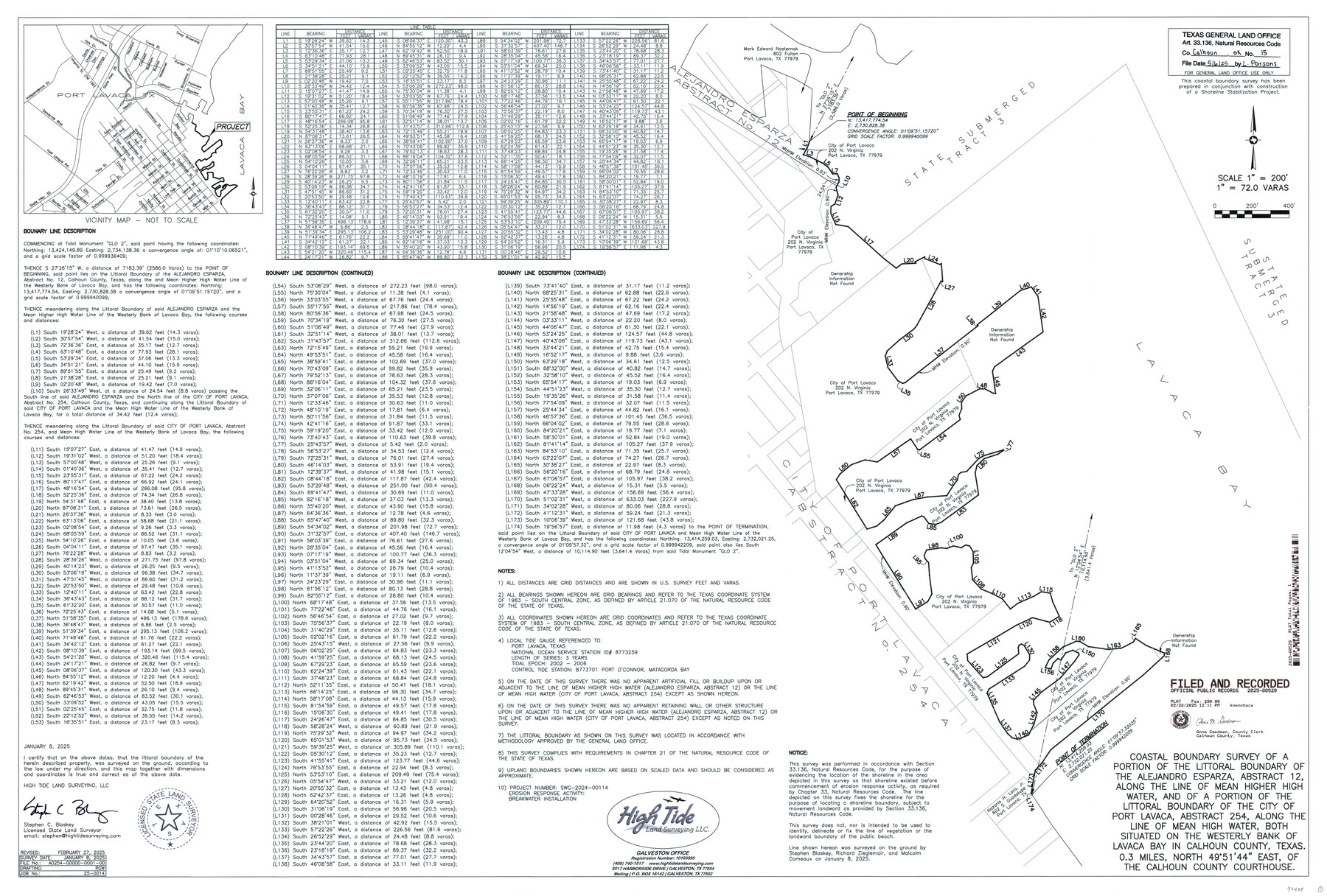
Calhoun County NRC Article 33.136 Sketch 15
Coastal Boundary Survey of a portion of the littoral boundary of the Alejandro Esparza, A-12, along the line of mean higher high water, and of a portion of the littoral boundary of the City of Port Lavaca, A-254, along the line of mean high water
-
Map/Doc
97428
-
Collection
General Map Collection
-
Object Dates
2/27/2025 (Creation Date)
5/6/2025 (File Date)
1/8/2025 (Survey Date)
-
People and Organizations
Stephen C. Blaskey (Surveyor/Engineer)
-
Counties
Calhoun
-
Subjects
Surveying CBS
-
Scale
1" = 200 feet
-
Comments
Project: City of Port Lavaca, A-254, Calhoun County - Blaskey
Project No.: SWG-2024-00114
Part of: General Map Collection

Montague County Boundary File 2c

Print $44.00
- Digital $50.00
Montague County Boundary File 2c
Size 9.0 x 14.5 inches
Map/Doc 57419
Flight Mission No. CGI-1N, Frame 144, Cameron County

Print $20.00
- Digital $50.00
Flight Mission No. CGI-1N, Frame 144, Cameron County
1955
Size 18.7 x 22.3 inches
Map/Doc 84500
Clay County Boundary File 17a

Print $40.00
- Digital $50.00
Clay County Boundary File 17a
Size 47.0 x 22.0 inches
Map/Doc 51435
Crosby County Working Sketch 10

Print $20.00
- Digital $50.00
Crosby County Working Sketch 10
1946
Size 44.5 x 23.7 inches
Map/Doc 68444
Pecos County Rolled Sketch 149

Print $20.00
- Digital $50.00
Pecos County Rolled Sketch 149
1958
Size 36.0 x 38.5 inches
Map/Doc 9735
Grimes County Working Sketch 16

Print $20.00
- Digital $50.00
Grimes County Working Sketch 16
1995
Size 41.6 x 33.1 inches
Map/Doc 63307
Brewster County Rolled Sketch 52

Print $40.00
- Digital $50.00
Brewster County Rolled Sketch 52
1935
Size 24.5 x 59.4 inches
Map/Doc 8479

Wood County Sketch File 12

Print $4.00
- Digital $50.00
Wood County Sketch File 12
1862
Size 12.8 x 8.3 inches
Map/Doc 40666
McCulloch County Rolled Sketch 6

Print $20.00
- Digital $50.00
McCulloch County Rolled Sketch 6
1982
Size 27.9 x 33.9 inches
Map/Doc 6717
Bexar County Sketch File 50

Print $40.00
- Digital $50.00
Bexar County Sketch File 50
1874
Size 22.5 x 18.2 inches
Map/Doc 10926
You may also like
![91955, [PSL Block B19], Twichell Survey Records](https://historictexasmaps.com/wmedia_w700/maps/91955-1.tif.jpg)
Harrison County Working Sketch 24

Print $20.00
- Digital $50.00
Harrison County Working Sketch 24
1983
Size 38.0 x 41.3 inches
Map/Doc 66044
Gregg County Rolled Sketch 16A

Print $20.00
- Digital $50.00
Gregg County Rolled Sketch 16A
1942
Size 30.1 x 40.4 inches
Map/Doc 6039
Upton County Rolled Sketch 36

Print $40.00
- Digital $50.00
Upton County Rolled Sketch 36
1952
Size 42.9 x 64.2 inches
Map/Doc 10051
Hamilton County Boundary File 5

Print $35.00
- Digital $50.00
Hamilton County Boundary File 5
Size 11.1 x 8.6 inches
Map/Doc 54217
Midland County Working Sketch 24

Print $40.00
- Digital $50.00
Midland County Working Sketch 24
1957
Size 42.9 x 80.9 inches
Map/Doc 71005
Gray County Sketch File 5

Print $16.00
- Digital $50.00
Gray County Sketch File 5
1882
Size 12.8 x 8.3 inches
Map/Doc 24418

Harrison County Working Sketch 27

Print $20.00
- Digital $50.00
Harrison County Working Sketch 27
1988
Size 29.2 x 36.9 inches
Map/Doc 66047
Kerr County Working Sketch 8

Print $20.00
- Digital $50.00
Kerr County Working Sketch 8
1948
Size 18.1 x 23.6 inches
Map/Doc 70039
Val Verde County Working Sketch 82

Print $20.00
- Digital $50.00
Val Verde County Working Sketch 82
1973
Size 42.1 x 33.1 inches
Map/Doc 72217
Map of Bexar County

Print $20.00
- Digital $50.00
Map of Bexar County
1878
Size 24.5 x 27.6 inches
Map/Doc 3298