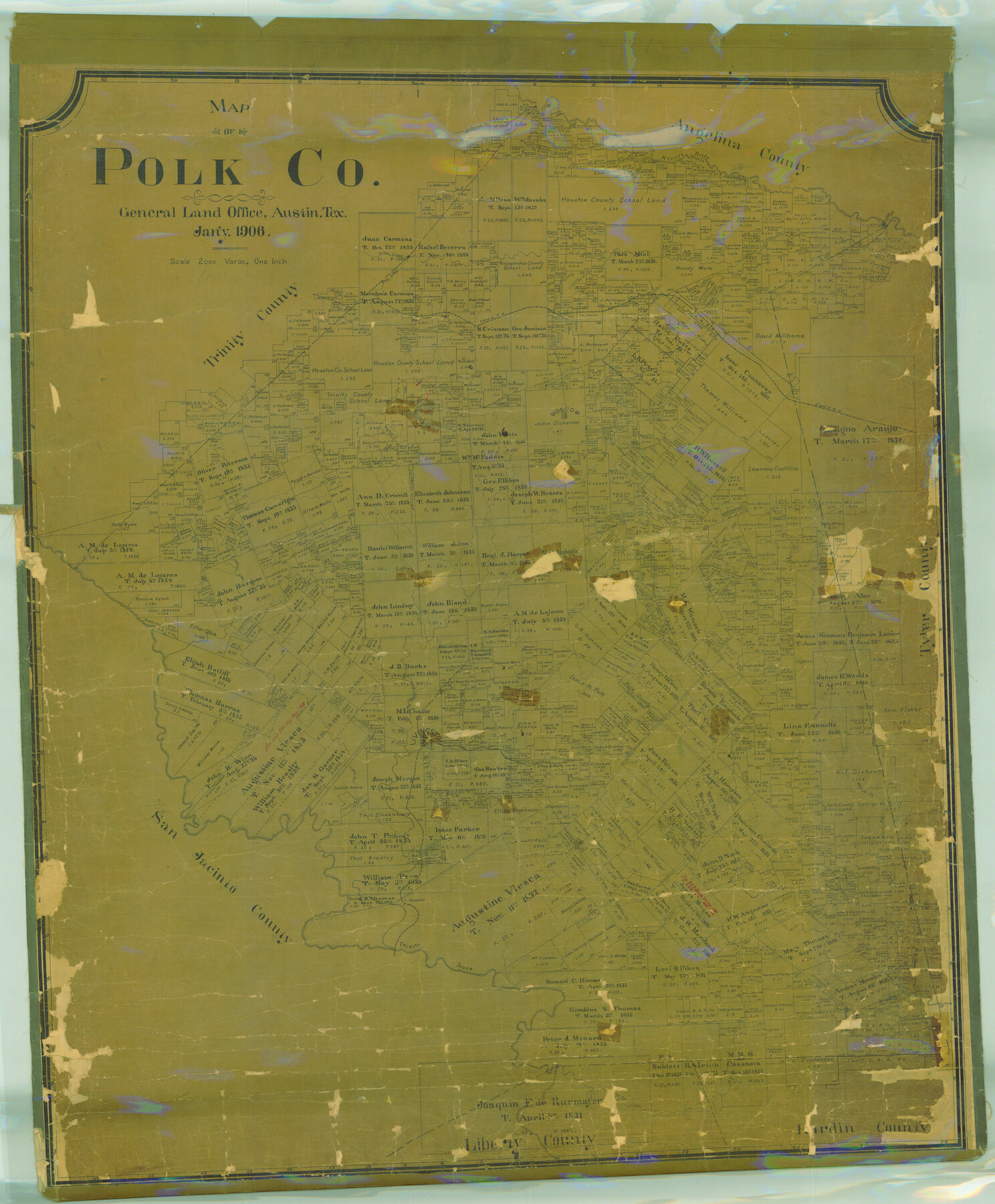
Map of Polk Co.
-
Map/Doc
16789
-
Collection
General Map Collection
-
Object Dates
1906 (Creation Date)
-
People and Organizations
Texas General Land Office (Publisher)
Morris (Compiler)
Morris (Draftsman)
-
Counties
Polk
-
Subjects
County
-
Height x Width
52.0 x 43.0 inches
132.1 x 109.2 cm
-
Comments
Help Save Texas History - Adopt Me!
-
Features
Tempy [sic] Creek
Tempy Creek
Geneva
Old School Creek
Iredell
Liberty to Nacogdoches Road
Bull Creek
L&S
Menard Creek
School Creek
Big Sandy Creek
Trinity River
Goodrich
Alabama Creek
Livingston
Choate's Creek
Knoxville
Liberty Road
Long King's Creek
Nacogdoches Road
Woods Creek
Kickapoo Creek
Moscow
T&S
Piney Creek
Neches River
Part of: General Map Collection
Gregg County Rolled Sketch 8

Print $40.00
- Digital $50.00
Gregg County Rolled Sketch 8
1933
Size 26.3 x 50.9 inches
Map/Doc 9027
Gray County Boundary File 3

Print $40.00
- Digital $50.00
Gray County Boundary File 3
Size 14.2 x 8.8 inches
Map/Doc 53854
Brewster County Working Sketch 79

Print $40.00
- Digital $50.00
Brewster County Working Sketch 79
1970
Size 52.8 x 32.6 inches
Map/Doc 67679
Coast Chart No. 210 Aransas Pass and Corpus Christi Bay with the coast to latitude 27° 12' Texas

Print $20.00
- Digital $50.00
Coast Chart No. 210 Aransas Pass and Corpus Christi Bay with the coast to latitude 27° 12' Texas
1913
Size 27.9 x 18.3 inches
Map/Doc 72806
Map of Jack County

Print $20.00
- Digital $50.00
Map of Jack County
1868
Size 23.8 x 19.8 inches
Map/Doc 3701
Map of Burnet Co.

Print $20.00
- Digital $50.00
Map of Burnet Co.
1887
Size 45.5 x 37.9 inches
Map/Doc 7816
Right of Way and Track Map, the Missouri, Kansas and Texas Ry. of Texas operated by the Missouri, Kansas and Texas Ry. of Texas, San Antonio Division

Print $40.00
- Digital $50.00
Right of Way and Track Map, the Missouri, Kansas and Texas Ry. of Texas operated by the Missouri, Kansas and Texas Ry. of Texas, San Antonio Division
1918
Size 25.6 x 58.7 inches
Map/Doc 64581
Kinney County Working Sketch 4

Print $20.00
- Digital $50.00
Kinney County Working Sketch 4
1907
Size 21.1 x 21.6 inches
Map/Doc 70186
Archer County Working Sketch 1

Print $20.00
- Digital $50.00
Archer County Working Sketch 1
Size 42.4 x 42.0 inches
Map/Doc 67141
Mason County Sketch File 5

Print $20.00
- Digital $50.00
Mason County Sketch File 5
1875
Size 15.8 x 12.9 inches
Map/Doc 12033
Cameron County Working Sketch Graphic Index

Print $20.00
- Digital $50.00
Cameron County Working Sketch Graphic Index
1976
Size 32.0 x 39.4 inches
Map/Doc 76486
Howard County Sketch File 11

Print $40.00
- Digital $50.00
Howard County Sketch File 11
1937
Size 17.6 x 10.2 inches
Map/Doc 26865
You may also like
Hill County Working Sketch 4

Print $20.00
- Digital $50.00
Hill County Working Sketch 4
1982
Size 25.3 x 23.3 inches
Map/Doc 66190
Flight Mission No. DAG-23K, Frame 149, Matagorda County

Print $20.00
- Digital $50.00
Flight Mission No. DAG-23K, Frame 149, Matagorda County
1953
Size 15.9 x 15.9 inches
Map/Doc 86497
Anderson County Sketch File 2

Print $4.00
- Digital $50.00
Anderson County Sketch File 2
1847
Size 12.6 x 8.2 inches
Map/Doc 12739
[Right of Way & Track Map, The Texas & Pacific Ry. Co. Main Line]
![64682, [Right of Way & Track Map, The Texas & Pacific Ry. Co. Main Line], General Map Collection](https://historictexasmaps.com/wmedia_w700/maps/64682.tif.jpg)
Print $20.00
- Digital $50.00
[Right of Way & Track Map, The Texas & Pacific Ry. Co. Main Line]
Size 11.4 x 18.4 inches
Map/Doc 64682
Flight Mission No. CRE-1R, Frame 124, Jackson County

Print $20.00
- Digital $50.00
Flight Mission No. CRE-1R, Frame 124, Jackson County
1956
Size 16.1 x 15.9 inches
Map/Doc 85335
[F. W. & D. C. Ry. Co. Alignment and Right of Way Map, Clay County]
![64743, [F. W. & D. C. Ry. Co. Alignment and Right of Way Map, Clay County], General Map Collection](https://historictexasmaps.com/wmedia_w700/maps/64743-GC.tif.jpg)
Print $20.00
- Digital $50.00
[F. W. & D. C. Ry. Co. Alignment and Right of Way Map, Clay County]
1927
Size 18.6 x 11.8 inches
Map/Doc 64743
Fannin County Boundary File 1

Print $14.00
- Digital $50.00
Fannin County Boundary File 1
Size 13.2 x 8.6 inches
Map/Doc 53272
Kimble County Working Sketch 24

Print $20.00
- Digital $50.00
Kimble County Working Sketch 24
1930
Size 23.3 x 17.4 inches
Map/Doc 70092
Crockett County Sketch File F

Print $20.00
- Digital $50.00
Crockett County Sketch File F
1907
Size 26.3 x 15.7 inches
Map/Doc 11240
Cass County Working Sketch 47a

Print $20.00
- Digital $50.00
Cass County Working Sketch 47a
1991
Size 29.5 x 39.5 inches
Map/Doc 67950

Polk County Working Sketch 23b

Print $40.00
- Digital $50.00
Polk County Working Sketch 23b
1957
Size 28.8 x 54.6 inches
Map/Doc 71639