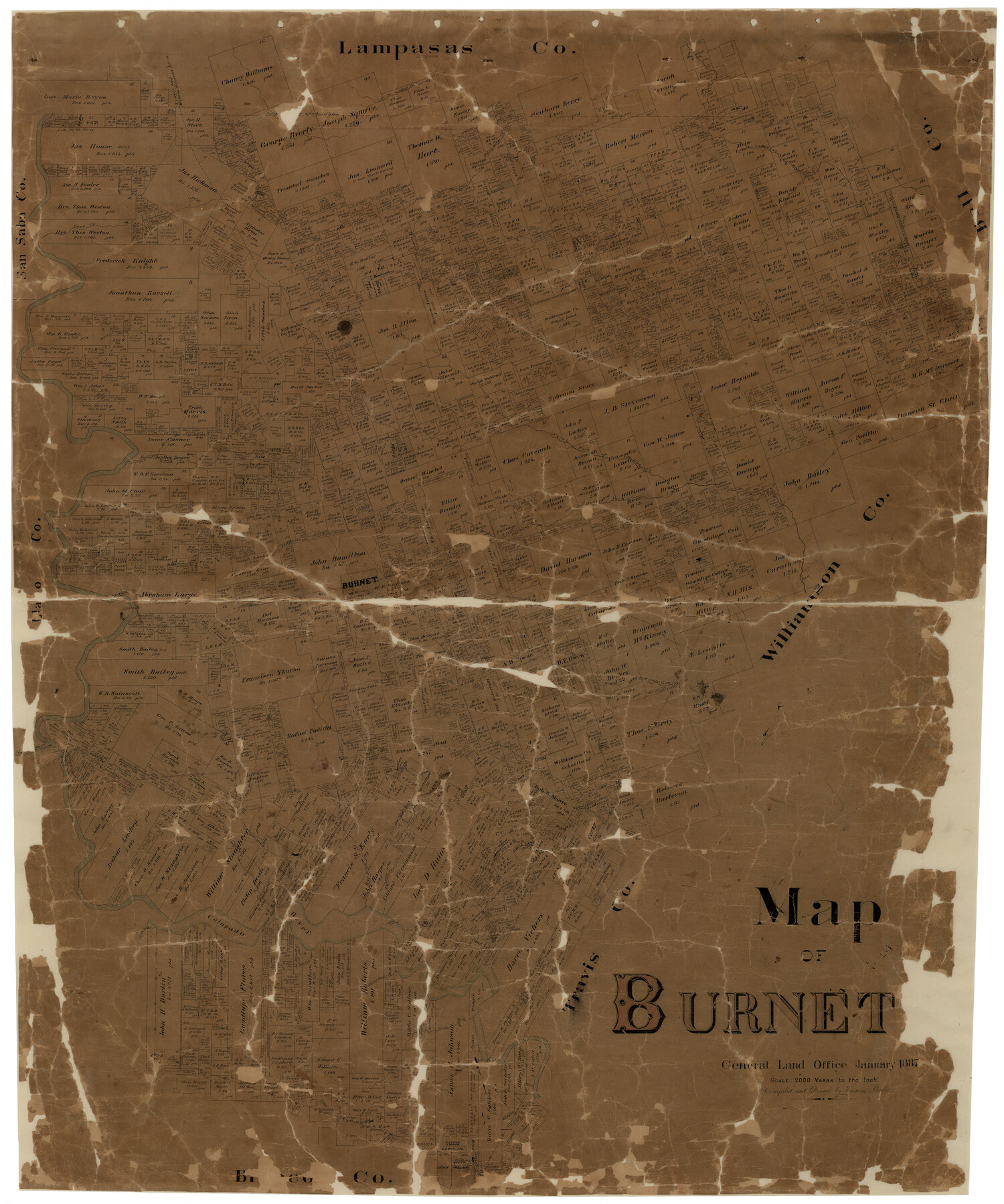
Map of Burnet Co.
-
Map/Doc
7816
-
Collection
General Map Collection
-
Object Dates
1887 (Creation Date)
-
People and Organizations
Texas General Land Office (Publisher)
Herman Pressler (Compiler)
Herman Pressler (Draftsman)
-
Counties
Burnet
-
Subjects
County
-
Height x Width
45.5 x 37.9 inches
115.6 x 96.3 cm
-
Comments
Conservation funded in 2001 with donations from Mr. and Mrs. Robert Garst Jr., and the Heart of Texas Chapter 21, Texas Society of Professional Surveyors.
-
Features
Colorado River
Kingsland
West Fork of Backbone Creek
East Fork of Backbone Creek
Spare Rib Creek
Backbone Creek
Cow Creek
Richland Creek
Hamilton Creek
Llano River
Marble Falls
Flat Rock Creek
Slick Rock Creek
Double Horn Creek
Love Creek
Little Cypress Creek
Deep Creek
H&TC
Beaver Creek
Sulphur Fork
Salt Fork
Mesquite Creek
Rocky Creek
Lampasas River
Mill Creek
Deer Creek
Lake Victor
Salt River
North Fork of San Gabriel River
Morgan Creek
Burnet
South Fork of San Gabriel River
Honey Creek
Hairston Creek
Mill Creek
Part of: General Map Collection
San Augustine County Working Sketch 25

Print $20.00
- Digital $50.00
San Augustine County Working Sketch 25
1976
Size 28.0 x 36.6 inches
Map/Doc 63713
Fisher County Working Sketch 3

Print $20.00
- Digital $50.00
Fisher County Working Sketch 3
1926
Size 19.7 x 15.7 inches
Map/Doc 69137
Fisher County Sketch File 17

Print $6.00
- Digital $50.00
Fisher County Sketch File 17
Size 11.0 x 12.5 inches
Map/Doc 22587
Stephens County Sketch File 23

Print $12.00
- Digital $50.00
Stephens County Sketch File 23
1919
Size 11.1 x 8.8 inches
Map/Doc 37084
Kendall County Sketch File 28

Print $12.00
- Digital $50.00
Kendall County Sketch File 28
1953
Size 14.3 x 8.9 inches
Map/Doc 28733
El Paso County Working Sketch 1

Print $40.00
- Digital $50.00
El Paso County Working Sketch 1
1911
Size 25.4 x 90.6 inches
Map/Doc 69022
Flight Mission No. CRK-3P, Frame 125, Refugio County

Print $20.00
- Digital $50.00
Flight Mission No. CRK-3P, Frame 125, Refugio County
1956
Size 18.5 x 22.5 inches
Map/Doc 86913
Flight Mission No. CRK-5P, Frame 123, Refugio County

Print $20.00
- Digital $50.00
Flight Mission No. CRK-5P, Frame 123, Refugio County
1956
Size 18.4 x 22.1 inches
Map/Doc 86926
Frio County Sketch File 21

Print $20.00
- Digital $50.00
Frio County Sketch File 21
1938
Size 23.4 x 24.3 inches
Map/Doc 11520
Colorado County Boundary File 2

Print $8.00
- Digital $50.00
Colorado County Boundary File 2
Size 14.3 x 8.7 inches
Map/Doc 51772

Montague County Working Sketch 18

Print $20.00
- Digital $50.00
Montague County Working Sketch 18
1948
Size 27.9 x 21.4 inches
Map/Doc 71084
You may also like
Presidio County Working Sketch 5

Print $20.00
- Digital $50.00
Presidio County Working Sketch 5
1917
Size 14.0 x 17.5 inches
Map/Doc 71679
Survey 1, Block 1, D.B. Gardner in Dickens County

Print $20.00
- Digital $50.00
Survey 1, Block 1, D.B. Gardner in Dickens County
1914
Size 14.9 x 30.4 inches
Map/Doc 10767
Jefferson County Working Sketch 40

Print $40.00
- Digital $50.00
Jefferson County Working Sketch 40
1985
Size 58.9 x 42.2 inches
Map/Doc 66584
Mills County Boundary File 3

Print $30.00
- Digital $50.00
Mills County Boundary File 3
Size 11.0 x 8.6 inches
Map/Doc 57281
Zavala County Sketch File 11

Print $4.00
- Digital $50.00
Zavala County Sketch File 11
1885
Size 14.4 x 8.8 inches
Map/Doc 41270
Jeff Davis County Working Sketch 41

Print $20.00
- Digital $50.00
Jeff Davis County Working Sketch 41
1981
Size 26.4 x 34.9 inches
Map/Doc 66536
Van Zandt County Sketch File 7

Print $8.00
- Digital $50.00
Van Zandt County Sketch File 7
1849
Size 5.2 x 7.4 inches
Map/Doc 39375
Flight Mission No. DIX-10P, Frame 147, Aransas County

Print $20.00
- Digital $50.00
Flight Mission No. DIX-10P, Frame 147, Aransas County
1956
Size 18.7 x 22.4 inches
Map/Doc 83949
Cameron County Aerial Photograph Index Sheet 4

Print $20.00
- Digital $50.00
Cameron County Aerial Photograph Index Sheet 4
1955
Size 19.3 x 17.4 inches
Map/Doc 83676
Acts of the Visit of the Royal Commissioners (sometimes referred to as the “Visita General”) - Laredo

Acts of the Visit of the Royal Commissioners (sometimes referred to as the “Visita General”) - Laredo
1797
Size 14.1 x 9.3 inches
Map/Doc 94256
Industrial - Commercial - Progressive Dallas

Industrial - Commercial - Progressive Dallas
1940
Size 19.1 x 23.7 inches
Map/Doc 96509
Tyler County Sketch File 31

Print $10.00
- Digital $50.00
Tyler County Sketch File 31
1941
Size 14.3 x 9.0 inches
Map/Doc 38723