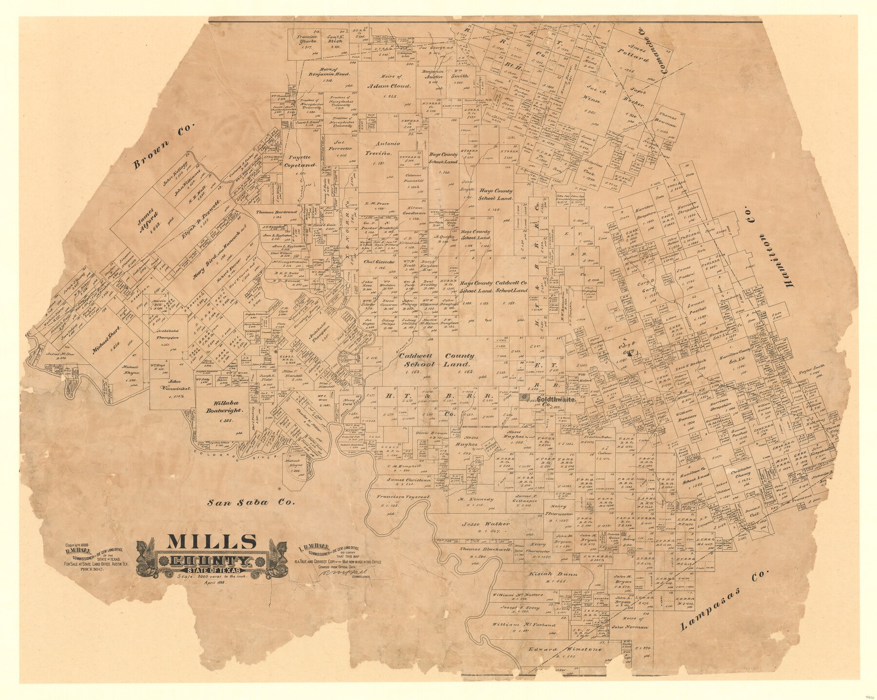
Mills County
-
Map/Doc
78426
-
Collection
General Map Collection
-
Object Dates
1888 (Creation Date)
-
People and Organizations
Texas General Land Office (Publisher)
R.M. Hall (GLO Commissioner)
August Gast Bank Note & Lithograph Company (Lithographer)
-
Counties
Mills
-
Subjects
County
-
Height x Width
32.2 x 40.0 inches
81.8 x 101.6 cm
-
Medium
paper, etching/engraving/lithograph
-
Comments
Help Save Texas History - Adopt Me!
-
Features
Cowhouse Creek
Blanket Creek
Pompey's Creek
Hampton Creek
Brown's Creek
Bennett Creek
Goldthwaite
Colorado River
Pecan Bayou
Prescott Branch [of Pecan Bayou]
Bulls Creek
Sims Creek
Part of: General Map Collection
Travis County Sketch File 35

Print $2.00
- Digital $50.00
Travis County Sketch File 35
Size 10.8 x 8.3 inches
Map/Doc 38354
El Paso County Sketch File 13

Print $8.00
- Digital $50.00
El Paso County Sketch File 13
1905
Size 7.4 x 6.8 inches
Map/Doc 22005
Nueces County Sketch File 66

Print $18.00
- Digital $50.00
Nueces County Sketch File 66
1981
Size 14.3 x 8.8 inches
Map/Doc 32989
Hutchinson County Working Sketch 3

Print $20.00
- Digital $50.00
Hutchinson County Working Sketch 3
Size 18.2 x 15.8 inches
Map/Doc 66361
Foard County Sketch File 31

Print $6.00
- Digital $50.00
Foard County Sketch File 31
1945
Size 14.5 x 9.1 inches
Map/Doc 22861
Map of Lee County

Print $20.00
- Digital $50.00
Map of Lee County
1888
Size 42.1 x 39.8 inches
Map/Doc 16876
Texas Panhandle East Boundary Line

Print $20.00
- Digital $50.00
Texas Panhandle East Boundary Line
Size 37.5 x 8.7 inches
Map/Doc 65381
Hudspeth County Sketch File 14

Print $12.00
- Digital $50.00
Hudspeth County Sketch File 14
1915
Size 14.3 x 8.8 inches
Map/Doc 26938
Aransas County Rolled Sketch 8

Print $20.00
- Digital $50.00
Aransas County Rolled Sketch 8
Size 41.0 x 43.5 inches
Map/Doc 8408
Brown County Working Sketch 16

Print $20.00
- Digital $50.00
Brown County Working Sketch 16
1993
Size 46.3 x 34.7 inches
Map/Doc 67781
Maverick County Sketch File 2

Print $40.00
- Digital $50.00
Maverick County Sketch File 2
1875
Size 18.2 x 14.0 inches
Map/Doc 31031
Stonewall County Rolled Sketch 14

Print $20.00
- Digital $50.00
Stonewall County Rolled Sketch 14
1902
Size 32.9 x 25.2 inches
Map/Doc 7869
You may also like
Stonewall County Rolled Sketch 24A

Print $40.00
- Digital $50.00
Stonewall County Rolled Sketch 24A
1954
Size 55.0 x 47.1 inches
Map/Doc 9963
![91463, [Block B7], Twichell Survey Records](https://historictexasmaps.com/wmedia_w700/maps/91463-1.tif.jpg)
Current Miscellaneous File 34

Print $10.00
- Digital $50.00
Current Miscellaneous File 34
1953
Size 14.1 x 8.7 inches
Map/Doc 73942
Palo Pinto County Working Sketch Graphic Index

Print $20.00
- Digital $50.00
Palo Pinto County Working Sketch Graphic Index
1941
Map/Doc 76659
Public School Land Leagues 1 through 63]
![92487, Public School Land Leagues 1 through 63], Twichell Survey Records](https://historictexasmaps.com/wmedia_w700/maps/92487-1.tif.jpg)
Print $20.00
- Digital $50.00
Public School Land Leagues 1 through 63]
Size 23.9 x 16.8 inches
Map/Doc 92487
Bowles's New Pocket Map of America divided into its Provinces, Colonies, States, Governments &c. exhibiting the British and Spanish Empires therein; together with the Territories belonging to the French, Dutch, Danes & Portuguese

Print $20.00
- Digital $50.00
Bowles's New Pocket Map of America divided into its Provinces, Colonies, States, Governments &c. exhibiting the British and Spanish Empires therein; together with the Territories belonging to the French, Dutch, Danes & Portuguese
1784
Size 21.3 x 23.1 inches
Map/Doc 93838
Terrell County Working Sketch 35a

Print $20.00
- Digital $50.00
Terrell County Working Sketch 35a
1948
Size 26.4 x 45.1 inches
Map/Doc 62128
Duval County Sketch File 42

Print $4.00
- Digital $50.00
Duval County Sketch File 42
1936
Size 14.4 x 8.8 inches
Map/Doc 21394
Kinney County Working Sketch 41

Print $20.00
- Digital $50.00
Kinney County Working Sketch 41
1973
Size 36.2 x 44.2 inches
Map/Doc 70223
Lampasas County Working Sketch 17

Print $20.00
- Digital $50.00
Lampasas County Working Sketch 17
1977
Size 24.0 x 13.2 inches
Map/Doc 70294
Runnels County Sketch File C

Print $4.00
Runnels County Sketch File C
Size 14.2 x 8.8 inches
Map/Doc 35457
Map of Copano, St. Charles, Aransas & Red Fish Bays in Aransas & Nueces Counties showing subdivision thereof for mineral development

Print $40.00
- Digital $50.00
Map of Copano, St. Charles, Aransas & Red Fish Bays in Aransas & Nueces Counties showing subdivision thereof for mineral development
Size 57.9 x 42.7 inches
Map/Doc 65805