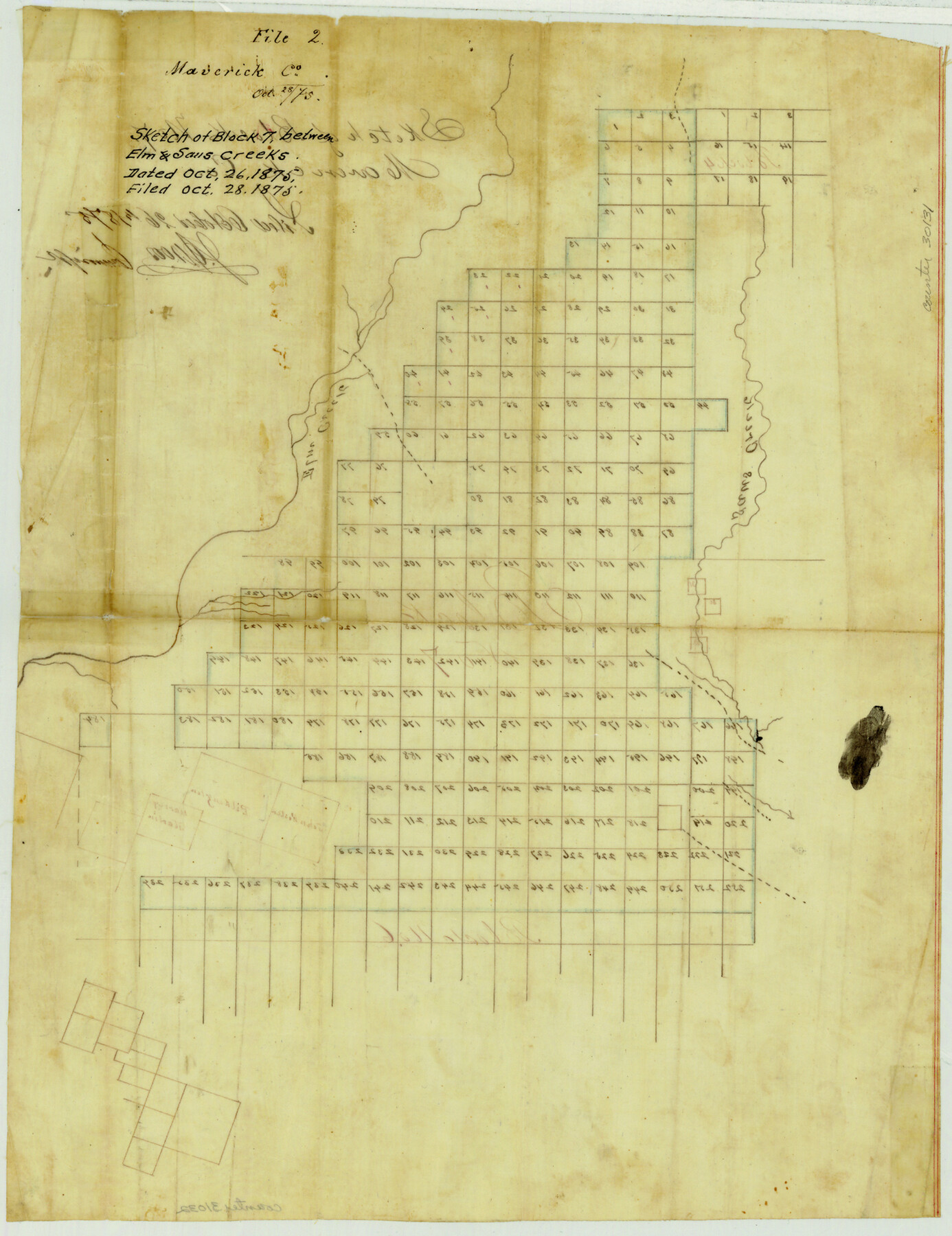
Maverick County Sketch File 2
[Sketch of Block 7 between Elm and Saus Creeks]
-
Map/Doc
31031
-
Collection
General Map Collection
-
Object Dates
10/26/1875 (Creation Date)
10/28/1875 (File Date)
-
Counties
Maverick
-
Subjects
Surveying Sketch File
-
Height x Width
18.2 x 14.0 inches
46.2 x 35.6 cm
-
Medium
paper, manuscript
-
Features
Elm Creek
Saus Creek
Part of: General Map Collection
University Land Field Note Volume Index

University Land Field Note Volume Index
2023
Size 8.5 x 11.0 inches
Map/Doc 97177
[Portion of Harris County]
![78481, [Portion of Harris County], General Map Collection](https://historictexasmaps.com/wmedia_w700/maps/78481.tif.jpg)
Print $2.00
- Digital $50.00
[Portion of Harris County]
Size 7.9 x 5.1 inches
Map/Doc 78481
Haskell County Sketch File 20

Print $20.00
- Digital $50.00
Haskell County Sketch File 20
1902
Size 20.9 x 26.2 inches
Map/Doc 11743
[Surveys on Trespalacios Bay]
![19, [Surveys on Trespalacios Bay], General Map Collection](https://historictexasmaps.com/wmedia_w700/maps/19.tif.jpg)
Print $2.00
- Digital $50.00
[Surveys on Trespalacios Bay]
Size 7.2 x 9.6 inches
Map/Doc 19
Gregg County Sketch File 1E

Print $4.00
- Digital $50.00
Gregg County Sketch File 1E
1849
Size 12.6 x 8.2 inches
Map/Doc 24545
Flight Mission No. CUG-3P, Frame 77, Kleberg County

Print $20.00
- Digital $50.00
Flight Mission No. CUG-3P, Frame 77, Kleberg County
1956
Size 18.7 x 22.4 inches
Map/Doc 86252
Kinney County Working Sketch 5

Print $20.00
- Digital $50.00
Kinney County Working Sketch 5
1910
Size 20.5 x 24.2 inches
Map/Doc 70187
Edwards County Working Sketch 122

Print $20.00
- Digital $50.00
Edwards County Working Sketch 122
1976
Size 25.8 x 33.9 inches
Map/Doc 68998
Newton County Sketch File 7

Print $4.00
- Digital $50.00
Newton County Sketch File 7
1872
Size 6.1 x 8.3 inches
Map/Doc 32374
Shackelford County Sketch File 14

Print $28.00
- Digital $50.00
Shackelford County Sketch File 14
1874
Size 14.4 x 8.8 inches
Map/Doc 36585
Jefferson County Rolled Sketch 62

Print $40.00
- Digital $50.00
Jefferson County Rolled Sketch 62
1974
Size 78.4 x 43.1 inches
Map/Doc 9318
Rusk County Rolled Sketch 8

Print $20.00
- Digital $50.00
Rusk County Rolled Sketch 8
1959
Size 22.6 x 26.3 inches
Map/Doc 7544
You may also like
Jefferson County Working Sketch 19

Print $20.00
- Digital $50.00
Jefferson County Working Sketch 19
1956
Size 32.2 x 24.4 inches
Map/Doc 66562
Freestone County Sketch File 5

Print $42.00
- Digital $50.00
Freestone County Sketch File 5
1854
Size 4.6 x 5.2 inches
Map/Doc 23047
McCulloch County Sketch File 15, 15a, 15b

Print $34.00
- Digital $50.00
McCulloch County Sketch File 15, 15a, 15b
1993
Size 11.2 x 8.8 inches
Map/Doc 31207
Burleson County State Real Property Sketch 1

Print $80.00
- Digital $50.00
Burleson County State Real Property Sketch 1
2003
Size 37.0 x 53.6 inches
Map/Doc 81907
Oldham County Sketch File 7

Print $86.00
- Digital $50.00
Oldham County Sketch File 7
1885
Size 9.4 x 9.1 inches
Map/Doc 33236
Stonewall County Working Sketch 32

Print $20.00
- Digital $50.00
Stonewall County Working Sketch 32
1983
Size 27.9 x 36.2 inches
Map/Doc 62339
[Map showing Jno. H. Gibson Block D]
![92005, [Map showing Jno. H. Gibson Block D], Twichell Survey Records](https://historictexasmaps.com/wmedia_w700/maps/92005-1.tif.jpg)
Print $20.00
- Digital $50.00
[Map showing Jno. H. Gibson Block D]
Size 18.3 x 15.9 inches
Map/Doc 92005
Burleson County Working Sketch 18

Print $20.00
- Digital $50.00
Burleson County Working Sketch 18
1980
Size 17.6 x 7.8 inches
Map/Doc 67737
Angelina County Working Sketch 50

Print $20.00
- Digital $50.00
Angelina County Working Sketch 50
1985
Size 34.2 x 43.2 inches
Map/Doc 67133
Gomez Section 1, Block D-12

Print $20.00
- Digital $50.00
Gomez Section 1, Block D-12
1955
Size 15.8 x 16.8 inches
Map/Doc 92321
[Block 1PD and Vicinity]
![91536, [Block 1PD and Vicinity], Twichell Survey Records](https://historictexasmaps.com/wmedia_w700/maps/91536-1.tif.jpg)
Print $3.00
- Digital $50.00
[Block 1PD and Vicinity]
Size 11.4 x 9.7 inches
Map/Doc 91536
[Map of Uvalde County]
![4108, [Map of Uvalde County], General Map Collection](https://historictexasmaps.com/wmedia_w700/maps/4108.tif.jpg)
Print $20.00
- Digital $50.00
[Map of Uvalde County]
1862
Size 27.7 x 26.7 inches
Map/Doc 4108