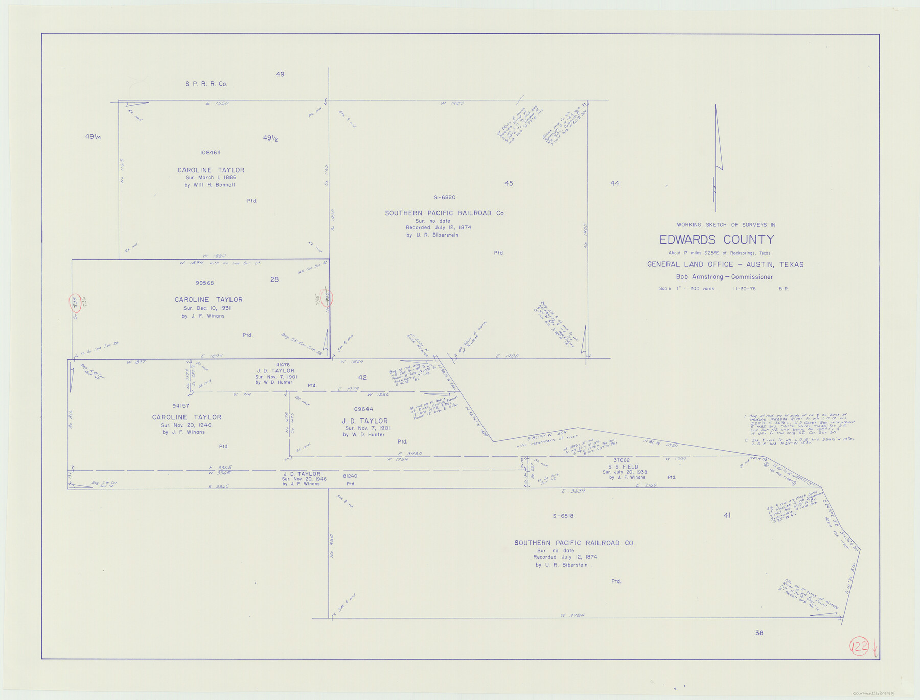
Edwards County Working Sketch 122
-
Map/Doc
68998
-
Collection
General Map Collection
-
Object Dates
11/30/1976 (Creation Date)
-
People and Organizations
Beverly Robison (Draftsman)
-
Counties
Edwards
-
Subjects
Surveying Working Sketch
-
Height x Width
25.8 x 33.9 inches
65.5 x 86.1 cm
-
Scale
1" = 200 varas
Part of: General Map Collection

Limestone County Working Sketch 9

Print $20.00
- Digital $50.00
Limestone County Working Sketch 9
1922
Size 18.5 x 19.2 inches
Map/Doc 70559
Montague County Working Sketch 36

Print $20.00
- Digital $50.00
Montague County Working Sketch 36
1980
Size 38.4 x 45.1 inches
Map/Doc 71102
Hutchinson County Sketch File 36

Print $10.00
- Digital $50.00
Hutchinson County Sketch File 36
1941
Size 11.2 x 8.9 inches
Map/Doc 27270
Stephens County Boundary File 81

Print $44.00
- Digital $50.00
Stephens County Boundary File 81
Size 9.2 x 3.8 inches
Map/Doc 58906
Bastrop County Sketch File 12

Print $12.00
- Digital $50.00
Bastrop County Sketch File 12
1846
Size 12.8 x 8.4 inches
Map/Doc 14064
Kimble County Sketch File B

Print $22.00
- Digital $50.00
Kimble County Sketch File B
Size 14.3 x 12.7 inches
Map/Doc 28963
Coryell County

Print $20.00
- Digital $50.00
Coryell County
1880
Size 25.6 x 25.6 inches
Map/Doc 3444
Cass County Working Sketch 16

Print $20.00
- Digital $50.00
Cass County Working Sketch 16
1957
Size 43.1 x 34.8 inches
Map/Doc 67919
Wichita County Working Sketch 6

Print $20.00
- Digital $50.00
Wichita County Working Sketch 6
1919
Size 24.6 x 21.4 inches
Map/Doc 72515
El Paso County Working Sketch 39

Print $20.00
- Digital $50.00
El Paso County Working Sketch 39
1984
Size 45.7 x 37.1 inches
Map/Doc 69061
Fisher County Sketch File 1

Print $20.00
- Digital $50.00
Fisher County Sketch File 1
Size 43.5 x 18.3 inches
Map/Doc 10448
You may also like
Houston Ship Channel, Alexander Island to Carpenter Bayou

Print $40.00
- Digital $50.00
Houston Ship Channel, Alexander Island to Carpenter Bayou
1992
Size 36.0 x 49.4 inches
Map/Doc 69918
Flight Mission No. DAG-21K, Frame 120, Matagorda County

Print $20.00
- Digital $50.00
Flight Mission No. DAG-21K, Frame 120, Matagorda County
1952
Size 18.5 x 22.3 inches
Map/Doc 86446
Hardin County

Print $20.00
- Digital $50.00
Hardin County
1940
Size 40.7 x 37.7 inches
Map/Doc 77303
Sketch J No. 2 Showing the Progress of the Survey of San Francisco Bay and Vicinity Section X From 1850 to 1852

Print $20.00
- Digital $50.00
Sketch J No. 2 Showing the Progress of the Survey of San Francisco Bay and Vicinity Section X From 1850 to 1852
1852
Size 12.3 x 12.7 inches
Map/Doc 97229
Parker County Rolled Sketch 6

Print $20.00
- Digital $50.00
Parker County Rolled Sketch 6
Size 28.3 x 34.1 inches
Map/Doc 7207
Angelina County Working Sketch 34

Print $20.00
- Digital $50.00
Angelina County Working Sketch 34
1956
Size 30.2 x 22.9 inches
Map/Doc 67117
General Highway Map, Knox County, Texas

Print $20.00
General Highway Map, Knox County, Texas
1961
Size 18.2 x 24.9 inches
Map/Doc 79560
Map of the country scouted by Colonels McKenzie and Shafter, Capt. R.P. Wilson and others in the years, 1874 & 1875

Print $20.00
- Digital $50.00
Map of the country scouted by Colonels McKenzie and Shafter, Capt. R.P. Wilson and others in the years, 1874 & 1875
1876
Size 43.0 x 31.8 inches
Map/Doc 62972
Mapa de los Estados Unidos de Méjico, Segun lo organizado y definido por las varias actas del Congreso de dicha Republica: y construido por las mejores autoridades

Print $20.00
Mapa de los Estados Unidos de Méjico, Segun lo organizado y definido por las varias actas del Congreso de dicha Republica: y construido por las mejores autoridades
1828
Size 29.3 x 41.6 inches
Map/Doc 76217
Newton County Working Sketch 45

Print $20.00
- Digital $50.00
Newton County Working Sketch 45
1996
Size 16.4 x 24.0 inches
Map/Doc 71291
Controlled Mosaic by Jack Amman Photogrammetric Engineers, Inc - Sheet 29

Print $20.00
- Digital $50.00
Controlled Mosaic by Jack Amman Photogrammetric Engineers, Inc - Sheet 29
1954
Size 20.0 x 24.0 inches
Map/Doc 83482
Map Showing Block HG and Connecting Surveys

Print $2.00
- Digital $50.00
Map Showing Block HG and Connecting Surveys
1907
Size 9.2 x 13.7 inches
Map/Doc 90681