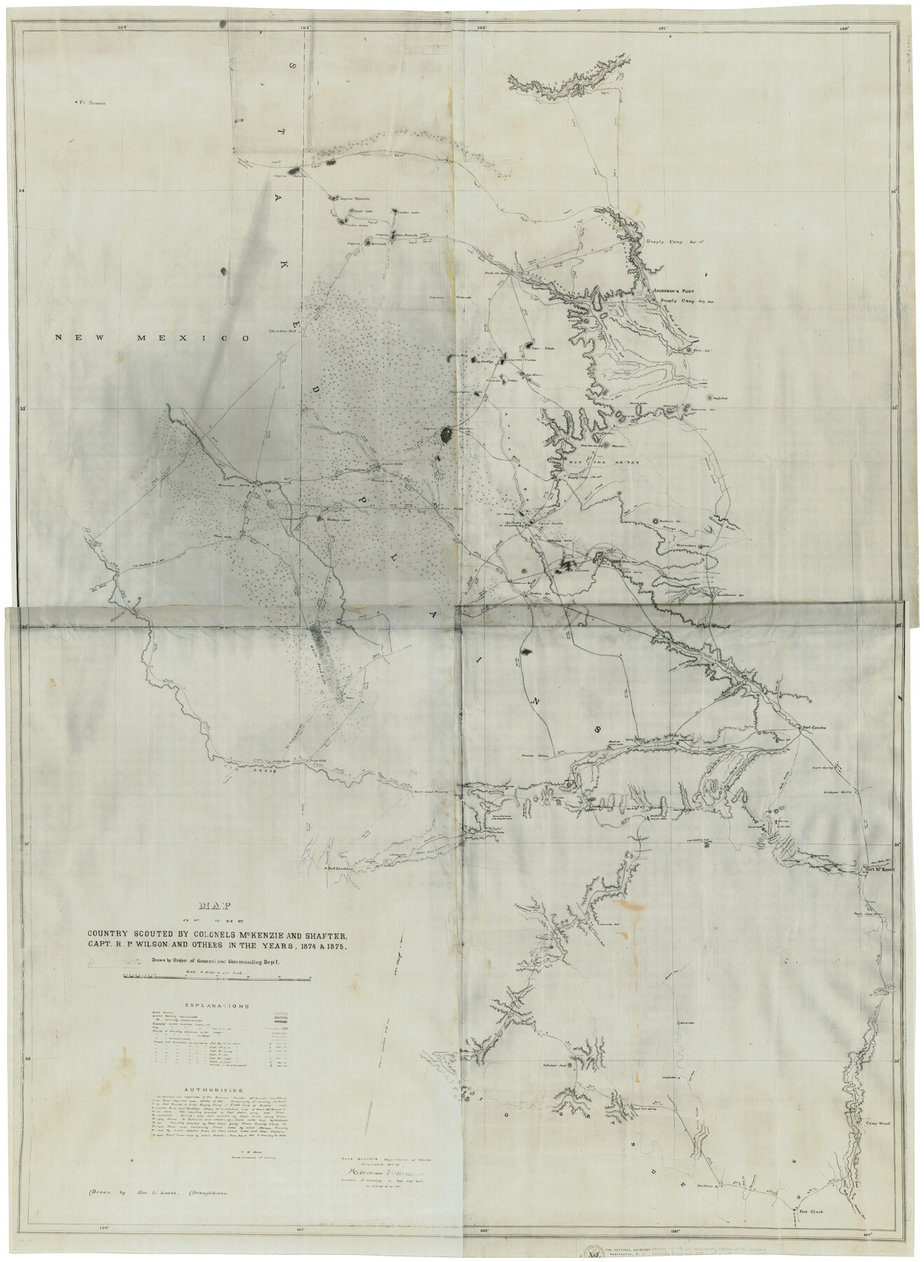
Map of the country scouted by Colonels McKenzie and Shafter, Capt. R.P. Wilson and others in the years, 1874 & 1875
-
Map/Doc
62972
-
Collection
General Map Collection
-
Object Dates
1876 (Creation Date)
-
People and Organizations
T.W. Jones (Military Officer)
Alex L. Lucas (Draftsman)
Herman Schreiver (Military Officer)
-
Subjects
Military
-
Height x Width
43.0 x 31.8 inches
109.2 x 80.8 cm
-
Medium
photostat
-
Scale
8 miles to one inch
-
Features
Ft. Sumner
Laguna Salados
Laguna Tejoneito
Hunt's Lake
Vieles Lakes
Lebo's Lake
Lagunas Casa Amarilla
Laguna Quemado
The Indian Well
Rio Azul
Delaware Creek
Rio Pecos
Toyah Creek
Adobe Walls
Pecos Falls
Leon Creek
Comanche Creek
Fort Stockton
Horsehead Crossing
Escondido Creek
Escondido
Middle Escondido
Little Escondido
Fort Clark
Las Moras Creek
Piedras Creek
Sycamore Creek
Mud Creek
San Felipe
Devils River
Paint Cave Spring
Colladays' Peak
Gasmann's Spring
Maxons Creek
Bedals Creek
Richland Creek
Independence Creek
San Antonio Road
Howard's Well
Bullis Waterhole
Geddes Spring
Mustang Waterholes
Lone Tree Mountain
Main Concho River
Good Spring Creek
Dove Creek
Sterlings Creek
Twin Mountains
Fort Concho
South Concho River
Road to Fort Concho
Round Top Mountain
22 Mile Waterhole
18 Mile Waterhole
13 Mile Waterhole
11 Mile Waterhole
8 Mile Waterhole
Fort McKavett
San Saba River
North Llano River
South Llano River
Camp Wood
East Fork Nueces River
West Fork Nueces River
Kickapoo Spring
Lipan Spring
Vine Creek
North Concho River
Lacey's Prong
Mustang Spring
Baldwins Spring
Five Wells
White Sand Hills
Shafter's Lake
Three Wells
Mountain Spring
McLean's Wells
Seminole Wells
Wards Wells
Rendelbrooks Spring
Girauds Creek
White Spring
Four Mountains
Big Spring
El Infierno
Custers Lake
Laguna Piedra
Ojo Piedra or Sulphur Springs
La Muerte
Arroyo Tabaco
Davis Creek
Hoyt's Creek
Henry's Creek
Boehan's Mt.
Shoemakers Peak
Colorado River
Culver's Creek
Moo-Cha-Ko-Way Mountain
Mount Gunther
Warrington Creek
Dursts Creek
Tyler's Creek
Arroyo Saeno
Cunningham Lake
French's Lakes
Ojo Blanco
Lagunas Cuates
Laguna Ombligo
Laguna Rica
Laguna Tohoko
Mackenzie Mountains
Wood's Peak
Agua de Toro
Leeper's Creek
Double Mountain Fork
White Mountain
Miller's Creek
Haleh's Hill
Fresh Fork of Brazos River
Anderson's Fort
Canon Blanco
Cañon Rescala
Cañon Tule
Staked Plains
Part of: General Map Collection
Val Verde County Rolled Sketch 1

Print $40.00
- Digital $50.00
Val Verde County Rolled Sketch 1
1885
Size 69.8 x 39.1 inches
Map/Doc 10068
Bandera County Sketch File 31

Print $40.00
- Digital $50.00
Bandera County Sketch File 31
1949
Size 17.7 x 22.2 inches
Map/Doc 10900
Lamb County Rolled Sketch 7

Print $20.00
- Digital $50.00
Lamb County Rolled Sketch 7
Size 45.6 x 26.3 inches
Map/Doc 9415
Jim Hogg County Rolled Sketch 14

Print $20.00
- Digital $50.00
Jim Hogg County Rolled Sketch 14
2023
Size 21.1 x 30.3 inches
Map/Doc 97155
Webb County Sketch File 6-2

Print $20.00
- Digital $50.00
Webb County Sketch File 6-2
1927
Size 29.4 x 21.3 inches
Map/Doc 12616
Flight Mission No. CRC-2R, Frame 194, Chambers County

Print $20.00
- Digital $50.00
Flight Mission No. CRC-2R, Frame 194, Chambers County
1956
Size 18.8 x 22.6 inches
Map/Doc 84772
Burleson County Working Sketch 13

Print $40.00
- Digital $50.00
Burleson County Working Sketch 13
1980
Size 49.2 x 34.6 inches
Map/Doc 67732
Rusk County Sketch File 32

Print $20.00
Rusk County Sketch File 32
1949
Size 33.5 x 28.4 inches
Map/Doc 10596
La Salle County Working Sketch 53

Print $20.00
- Digital $50.00
La Salle County Working Sketch 53
Size 14.3 x 15.9 inches
Map/Doc 67362
Loving County Sketch File 1

Print $4.00
- Digital $50.00
Loving County Sketch File 1
1931
Size 11.2 x 8.6 inches
Map/Doc 30407
Flight Mission No. BRA-8M, Frame 143, Jefferson County

Print $20.00
- Digital $50.00
Flight Mission No. BRA-8M, Frame 143, Jefferson County
1953
Size 18.9 x 22.5 inches
Map/Doc 85635
Pecos County Rolled Sketch 43

Print $20.00
- Digital $50.00
Pecos County Rolled Sketch 43
1912
Size 25.4 x 34.8 inches
Map/Doc 7221
You may also like
J. De Cordova's Map of the State of Texas Compiled from the records of the General Land Office of the State

Print $20.00
- Digital $50.00
J. De Cordova's Map of the State of Texas Compiled from the records of the General Land Office of the State
1851
Size 34.9 x 32.0 inches
Map/Doc 442
Tom Green County Rolled Sketch 6

Print $20.00
- Digital $50.00
Tom Green County Rolled Sketch 6
Size 21.6 x 17.1 inches
Map/Doc 7995
Pecos County Working Sketch 139

Print $20.00
- Digital $50.00
Pecos County Working Sketch 139
1982
Size 31.1 x 24.9 inches
Map/Doc 71613
Yoakum-Terry County Sketch

Print $20.00
- Digital $50.00
Yoakum-Terry County Sketch
Size 9.6 x 27.5 inches
Map/Doc 92932
Coast Chart No. 211 - Padre I. and Laguna Madre Lat. 27° 12' to Lat. 26° 33' Texas

Print $20.00
- Digital $50.00
Coast Chart No. 211 - Padre I. and Laguna Madre Lat. 27° 12' to Lat. 26° 33' Texas
1890
Size 27.5 x 18.2 inches
Map/Doc 72824
Galveston County Sketch File 4

Print $6.00
- Digital $50.00
Galveston County Sketch File 4
1850
Size 12.8 x 8.0 inches
Map/Doc 23355
Galveston County Rolled Sketch 44

Print $20.00
- Digital $50.00
Galveston County Rolled Sketch 44
1991
Size 25.1 x 36.8 inches
Map/Doc 5974
Southern Part of Laguna Madre

Print $20.00
- Digital $50.00
Southern Part of Laguna Madre
1949
Size 33.8 x 26.7 inches
Map/Doc 73536

Garden City Townsite, Section 5, Range 4 South, Block 33

Print $2.00
- Digital $50.00
Garden City Townsite, Section 5, Range 4 South, Block 33
1886
Size 9.0 x 15.4 inches
Map/Doc 90763
Maverick County Sketch File 28

Print $4.00
- Digital $50.00
Maverick County Sketch File 28
1893
Size 11.0 x 8.9 inches
Map/Doc 31163
Duval County Sketch File 29

Print $6.00
- Digital $50.00
Duval County Sketch File 29
1932
Size 14.6 x 8.8 inches
Map/Doc 21336