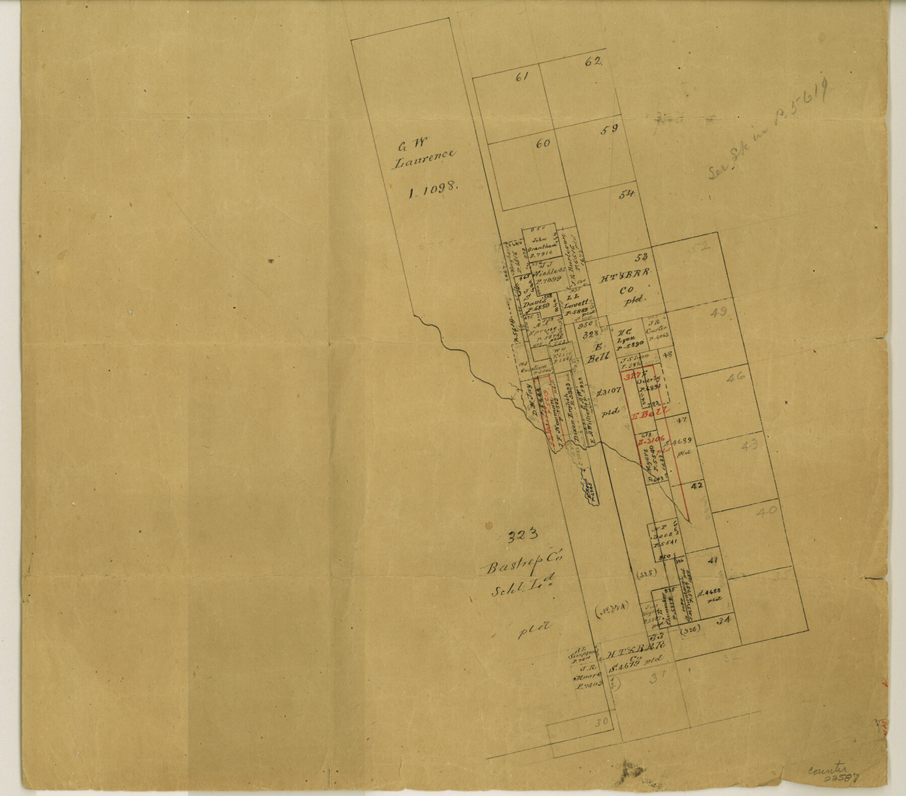
Fisher County Sketch File 17
[Office sketch of surveys around the E. Bell tract]
-
Map/Doc
22587
-
Collection
General Map Collection
-
People and Organizations
Pressler (Surveyor/Engineer)
-
Counties
Fisher
-
Subjects
Surveying Sketch File
-
Height x Width
11.0 x 12.5 inches
27.9 x 31.8 cm
-
Medium
paper, manuscript
Part of: General Map Collection
Upton County Sketch File 19

Print $20.00
- Digital $50.00
Upton County Sketch File 19
1927
Size 21.2 x 21.4 inches
Map/Doc 12515
Tyler County Rolled Sketch 8

Print $20.00
- Digital $50.00
Tyler County Rolled Sketch 8
1965
Size 18.1 x 25.4 inches
Map/Doc 8058
Laguna Madre, Register No. 1477B

Print $40.00
- Digital $50.00
Laguna Madre, Register No. 1477B
1880
Size 33.4 x 56.6 inches
Map/Doc 73607
Bailey County Sketch File 13

Print $40.00
- Digital $50.00
Bailey County Sketch File 13
1912
Size 19.2 x 20.6 inches
Map/Doc 10888
Duval County Working Sketch 47

Print $20.00
- Digital $50.00
Duval County Working Sketch 47
1981
Size 20.8 x 30.9 inches
Map/Doc 68771
Real County Working Sketch 44

Print $20.00
- Digital $50.00
Real County Working Sketch 44
1953
Size 28.3 x 24.3 inches
Map/Doc 71936
Red River County Working Sketch 75

Print $20.00
- Digital $50.00
Red River County Working Sketch 75
1980
Size 30.4 x 24.6 inches
Map/Doc 72058
Dimmit County Working Sketch 34

Print $20.00
- Digital $50.00
Dimmit County Working Sketch 34
1959
Size 22.8 x 17.0 inches
Map/Doc 68695
Montgomery County Boundary File 2

Print $6.00
- Digital $50.00
Montgomery County Boundary File 2
Size 17.1 x 11.4 inches
Map/Doc 57448
Flight Mission No. BRE-1P, Frame 99, Nueces County

Print $20.00
- Digital $50.00
Flight Mission No. BRE-1P, Frame 99, Nueces County
1956
Size 18.4 x 22.2 inches
Map/Doc 86670
Nueces County

Print $20.00
- Digital $50.00
Nueces County
1913
Size 26.4 x 34.1 inches
Map/Doc 66957
Castro County Sketch File 4c

Print $4.00
- Digital $50.00
Castro County Sketch File 4c
Size 12.7 x 8.8 inches
Map/Doc 17469
You may also like
[Cotton Belt, St. Louis Southwestern Railway of Texas, Alignment through Smith County]
![64375, [Cotton Belt, St. Louis Southwestern Railway of Texas, Alignment through Smith County], General Map Collection](https://historictexasmaps.com/wmedia_w700/maps/64375.tif.jpg)
Print $20.00
- Digital $50.00
[Cotton Belt, St. Louis Southwestern Railway of Texas, Alignment through Smith County]
1903
Size 21.3 x 28.5 inches
Map/Doc 64375
General Highway Map. Detail of Cities and Towns in Harris County, Texas. City Map [of] Houston, Pasadena, West University Place, Bellaire, Galena Park, Jacinto City, South Houston, South Side Place, Deer Park, and vicinity, Harris County, Texas
![79507, General Highway Map. Detail of Cities and Towns in Harris County, Texas. City Map [of] Houston, Pasadena, West University Place, Bellaire, Galena Park, Jacinto City, South Houston, South Side Place, Deer Park, and vicinity, Harris County, Texas, Texas State Library and Archives](https://historictexasmaps.com/wmedia_w700/maps/79507.tif.jpg)
Print $20.00
General Highway Map. Detail of Cities and Towns in Harris County, Texas. City Map [of] Houston, Pasadena, West University Place, Bellaire, Galena Park, Jacinto City, South Houston, South Side Place, Deer Park, and vicinity, Harris County, Texas
1961
Size 18.1 x 24.7 inches
Map/Doc 79507
Llano County Working Sketch 11

Print $40.00
- Digital $50.00
Llano County Working Sketch 11
1983
Size 38.0 x 48.2 inches
Map/Doc 70629
A.R. Roessler's Latest Map of the State of Texas Exhibiting Mineral and Agricultural Districts, Post Offices & Mailroutes, Railroads projected and finished, Timber, Prairie, Swamp Lands, etc. etc. etc.

Print $20.00
- Digital $50.00
A.R. Roessler's Latest Map of the State of Texas Exhibiting Mineral and Agricultural Districts, Post Offices & Mailroutes, Railroads projected and finished, Timber, Prairie, Swamp Lands, etc. etc. etc.
1874
Size 39.9 x 44.6 inches
Map/Doc 95369
McMullen County Sketch File 30

Print $20.00
- Digital $50.00
McMullen County Sketch File 30
1884
Size 38.5 x 21.1 inches
Map/Doc 10540
Wood County Sketch File 8

Print $6.00
- Digital $50.00
Wood County Sketch File 8
1850
Size 12.5 x 8.3 inches
Map/Doc 40653
Brewster County Working Sketch 45

Print $40.00
- Digital $50.00
Brewster County Working Sketch 45
1948
Size 53.6 x 36.1 inches
Map/Doc 67579
Map of the United States and Texas Boundary Line and adjacent territory determined & surveyed in 1857-8-9-60 by J.H. Clark, U.S. Commissioner, &ca. &ca. under the direction of the Departement [sic] of the Interior
![94063, Map of the United States and Texas Boundary Line and adjacent territory determined & surveyed in 1857-8-9-60 by J.H. Clark, U.S. Commissioner, &ca. &ca. under the direction of the Departement [sic] of the Interior, General Map Collection](https://historictexasmaps.com/wmedia_w700/maps/94063.tif.jpg)
Print $20.00
- Digital $50.00
Map of the United States and Texas Boundary Line and adjacent territory determined & surveyed in 1857-8-9-60 by J.H. Clark, U.S. Commissioner, &ca. &ca. under the direction of the Departement [sic] of the Interior
1902
Size 27.9 x 41.8 inches
Map/Doc 94063
Pecos County Sketch File 27

Print $20.00
- Digital $50.00
Pecos County Sketch File 27
1900
Size 18.1 x 14.5 inches
Map/Doc 12165
Wilbarger County Working Sketch 9

Print $20.00
- Digital $50.00
Wilbarger County Working Sketch 9
1950
Size 21.3 x 27.6 inches
Map/Doc 72547
General Highway Map, Calhoun County, Texas

Print $20.00
General Highway Map, Calhoun County, Texas
1961
Size 18.3 x 24.4 inches
Map/Doc 79395
The North Part of America Conteyning Newfoundland, New England, Virginia, Florida, New Spaine, and Nova Francia

Print $20.00
- Digital $50.00
The North Part of America Conteyning Newfoundland, New England, Virginia, Florida, New Spaine, and Nova Francia
1625
Size 12.6 x 16.2 inches
Map/Doc 97028