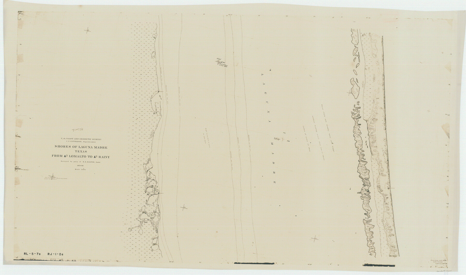
Laguna Madre, Register No. 1477B
From Triangulation Station Lomalto to Triangulation Station Rainy
-
Map/Doc
73607
-
Collection
General Map Collection
-
Object Dates
1880 (Creation Date)
-
Subjects
Nautical Charts
-
Height x Width
33.4 x 56.6 inches
84.8 x 143.8 cm
Part of: General Map Collection
Palo Duro Canyon Park

Print $20.00
- Digital $50.00
Palo Duro Canyon Park
1950
Size 25.2 x 37.9 inches
Map/Doc 73567
Blanco County Working Sketch 36

Print $20.00
- Digital $50.00
Blanco County Working Sketch 36
1979
Size 23.8 x 22.0 inches
Map/Doc 67396
Jefferson County Sketch File 1

Print $2.00
- Digital $50.00
Jefferson County Sketch File 1
Size 8.8 x 7.6 inches
Map/Doc 28086
Erath County Sketch File 12a

Print $4.00
- Digital $50.00
Erath County Sketch File 12a
1871
Size 12.7 x 8.2 inches
Map/Doc 22283
Cooke County Working Sketch 33

Print $20.00
- Digital $50.00
Cooke County Working Sketch 33
Size 25.6 x 28.6 inches
Map/Doc 68270
Angelina River, Mud Creek, Sheet 3

Print $4.00
- Digital $50.00
Angelina River, Mud Creek, Sheet 3
1937
Size 18.7 x 26.6 inches
Map/Doc 65077
Reagan County Working Sketch 24

Print $20.00
- Digital $50.00
Reagan County Working Sketch 24
Size 45.4 x 39.9 inches
Map/Doc 71866
Flight Mission No. BRE-2P, Frame 94, Nueces County

Print $20.00
- Digital $50.00
Flight Mission No. BRE-2P, Frame 94, Nueces County
1956
Size 18.6 x 22.3 inches
Map/Doc 86779
Clay County Working Sketch 4
Print $20.00
- Digital $50.00
Clay County Working Sketch 4
Size 14.7 x 21.9 inches
Map/Doc 68027
Webb County Sketch File 5

Print $8.00
- Digital $50.00
Webb County Sketch File 5
1876
Size 12.8 x 8.1 inches
Map/Doc 39725
International boundary between U.S. & Mexico in Gulf of Mexico from 12 mile point easterly to 200 mile limit

Print $3.00
- Digital $50.00
International boundary between U.S. & Mexico in Gulf of Mexico from 12 mile point easterly to 200 mile limit
1976
Size 9.6 x 14.8 inches
Map/Doc 1748
Upton County Working Sketch 4

Print $20.00
- Digital $50.00
Upton County Working Sketch 4
Size 21.8 x 33.9 inches
Map/Doc 69500
You may also like
Martin County Working Sketch 1

Print $20.00
- Digital $50.00
Martin County Working Sketch 1
Size 21.8 x 16.9 inches
Map/Doc 70819
Galveston County NRC Article 33.136 Sketch 27

Print $126.00
- Digital $50.00
Galveston County NRC Article 33.136 Sketch 27
2003
Size 24.4 x 36.2 inches
Map/Doc 81970
Brazoria County Sketch File 39

Print $8.00
- Digital $50.00
Brazoria County Sketch File 39
1933
Size 11.3 x 8.8 inches
Map/Doc 15045
Maps & Lists Showing Prison Lands (Oil & Gas) Leased as of June 1955

Digital $50.00
Maps & Lists Showing Prison Lands (Oil & Gas) Leased as of June 1955
Size 11.2 x 8.9 inches
Map/Doc 62875
Andrews County Working Sketch 1

Print $20.00
- Digital $50.00
Andrews County Working Sketch 1
1946
Size 40.4 x 37.3 inches
Map/Doc 67047
Dallas County Working Sketch 6
Print $20.00
- Digital $50.00
Dallas County Working Sketch 6
Size 16.7 x 25.9 inches
Map/Doc 68572
Palo Pinto County Sketch File 8

Print $40.00
- Digital $50.00
Palo Pinto County Sketch File 8
Size 15.3 x 15.6 inches
Map/Doc 33400
The Judicial District/County of Trinity. Abolished, Spring 1842

Print $20.00
- Digital $50.00
The Judicial District/County of Trinity. Abolished, Spring 1842
2020
Size 7.3 x 10.8 inches
Map/Doc 96351
Taylor County Boundary File 1

Print $44.00
- Digital $50.00
Taylor County Boundary File 1
Size 8.4 x 8.2 inches
Map/Doc 59184
Harris County Sketch File 93

Print $20.00
- Digital $50.00
Harris County Sketch File 93
1952
Size 33.0 x 14.5 inches
Map/Doc 11676
Dallas County Rolled Sketch 5

Print $20.00
- Digital $50.00
Dallas County Rolled Sketch 5
1955
Size 23.8 x 30.8 inches
Map/Doc 5689
[Gunter & Munson Maddox Bros. & Anderson Blocks F, O, N, A and vicinity]
![93203, [Gunter & Munson Maddox Bros. & Anderson Blocks F, O, N, A and vicinity], Twichell Survey Records](https://historictexasmaps.com/wmedia_w700/maps/93203.tif.jpg)
Print $40.00
- Digital $50.00
[Gunter & Munson Maddox Bros. & Anderson Blocks F, O, N, A and vicinity]
1929
Size 81.0 x 15.2 inches
Map/Doc 93203