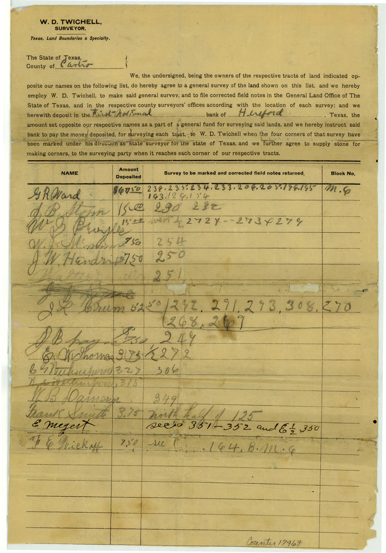
Castro County Sketch File 4c
[Agreement for W.D. Twichell to survey multiple sections within Block M6]
-
Map/Doc
17469
-
Collection
General Map Collection
-
People and Organizations
W.D. Twichell (Surveyor/Engineer)
-
Counties
Castro Randall
-
Subjects
Surveying Sketch File
-
Height x Width
12.7 x 8.8 inches
32.3 x 22.4 cm
-
Medium
paper, print with manuscript additions
Part of: General Map Collection
Menard County Sketch File 22

Print $8.00
- Digital $50.00
Menard County Sketch File 22
1927
Size 7.4 x 8.6 inches
Map/Doc 31553
Hutchinson County Rolled Sketch 44-15

Print $20.00
- Digital $50.00
Hutchinson County Rolled Sketch 44-15
2002
Size 24.0 x 36.0 inches
Map/Doc 77551
Culberson County Rolled Sketch 58

Print $40.00
- Digital $50.00
Culberson County Rolled Sketch 58
1979
Size 37.8 x 52.6 inches
Map/Doc 8759
Flight Mission No. DQN-6K, Frame 11, Calhoun County

Print $20.00
- Digital $50.00
Flight Mission No. DQN-6K, Frame 11, Calhoun County
1953
Size 18.4 x 22.2 inches
Map/Doc 84433
Wichita County Rolled Sketch 18

Print $20.00
- Digital $50.00
Wichita County Rolled Sketch 18
1923
Size 25.7 x 38.0 inches
Map/Doc 8254
Map of McCulloch County

Print $20.00
- Digital $50.00
Map of McCulloch County
1874
Size 26.7 x 20.7 inches
Map/Doc 3857
Terry County Sketch File 8

Print $20.00
- Digital $50.00
Terry County Sketch File 8
1932
Size 23.2 x 42.5 inches
Map/Doc 10393
Sutton County Working Sketch 63

Print $20.00
- Digital $50.00
Sutton County Working Sketch 63
1961
Size 26.0 x 29.9 inches
Map/Doc 62406
Current Miscellaneous File 63

Print $6.00
- Digital $50.00
Current Miscellaneous File 63
1957
Size 14.1 x 8.8 inches
Map/Doc 74100
Edwards County Boundary File 27e

Print $11.00
- Digital $50.00
Edwards County Boundary File 27e
Size 12.8 x 8.5 inches
Map/Doc 52906
Controlled Mosaic by Jack Amman Photogrammetric Engineers, Inc - Sheet 11

Print $20.00
- Digital $50.00
Controlled Mosaic by Jack Amman Photogrammetric Engineers, Inc - Sheet 11
1954
Size 20.0 x 24.0 inches
Map/Doc 83455
[Maps of surveys in Reeves & Culberson Cos]
![61132, [Maps of surveys in Reeves & Culberson Cos], General Map Collection](https://historictexasmaps.com/wmedia_w700/maps/61132.tif.jpg)
Print $20.00
- Digital $50.00
[Maps of surveys in Reeves & Culberson Cos]
1937
Size 30.8 x 24.9 inches
Map/Doc 61132
You may also like
[Texas & Pacific Railway, Longview to Dallas]
![64098, [Texas & Pacific Railway, Longview to Dallas], General Map Collection](https://historictexasmaps.com/wmedia_w700/maps/64098.tif.jpg)
Print $40.00
- Digital $50.00
[Texas & Pacific Railway, Longview to Dallas]
1873
Size 14.5 x 121.6 inches
Map/Doc 64098
Map of Zapata County

Print $20.00
- Digital $50.00
Map of Zapata County
1879
Size 27.4 x 25.6 inches
Map/Doc 4176
Jasper County Sketch File 33

Print $20.00
- Digital $50.00
Jasper County Sketch File 33
1938
Size 23.0 x 17.6 inches
Map/Doc 11854
[Township 3 North, Blocks 31 and 32]
![91213, [Township 3 North, Blocks 31 and 32], Twichell Survey Records](https://historictexasmaps.com/wmedia_w700/maps/91213-1.tif.jpg)
Print $3.00
- Digital $50.00
[Township 3 North, Blocks 31 and 32]
Size 12.5 x 10.8 inches
Map/Doc 91213
Bosque County Boundary File 11

Print $10.00
- Digital $50.00
Bosque County Boundary File 11
Size 8.8 x 7.0 inches
Map/Doc 50689
Hamilton County Boundary File 6

Print $4.00
- Digital $50.00
Hamilton County Boundary File 6
Size 11.2 x 8.6 inches
Map/Doc 54225
[Map of the Line of the H. & Texas Cen. Railway from the Navasota River, 72 1/2 Miles from Houston, to Corsicana in Navarro Co., 211 mls from Houston]
![64087, [Map of the Line of the H. & Texas Cen. Railway from the Navasota River, 72 1/2 Miles from Houston, to Corsicana in Navarro Co., 211 mls from Houston], General Map Collection](https://historictexasmaps.com/wmedia_w700/maps/64087.tif.jpg)
Print $40.00
- Digital $50.00
[Map of the Line of the H. & Texas Cen. Railway from the Navasota River, 72 1/2 Miles from Houston, to Corsicana in Navarro Co., 211 mls from Houston]
Size 75.6 x 39.6 inches
Map/Doc 64087
Montgomery County Working Sketch 23

Print $20.00
- Digital $50.00
Montgomery County Working Sketch 23
1937
Size 42.5 x 37.2 inches
Map/Doc 71130
Live Oak County Working Sketch 19

Print $20.00
- Digital $50.00
Live Oak County Working Sketch 19
1962
Size 27.4 x 34.5 inches
Map/Doc 70604
Geographically Correct County Map showing the lines of the Cotton Belt Route and connections

Print $20.00
- Digital $50.00
Geographically Correct County Map showing the lines of the Cotton Belt Route and connections
1902
Size 35.9 x 30.7 inches
Map/Doc 95840
Real County Working Sketch 80

Print $20.00
- Digital $50.00
Real County Working Sketch 80
1984
Size 37.9 x 43.3 inches
Map/Doc 71972
Flight Mission No. CUG-1P, Frame 50, Kleberg County

Print $20.00
- Digital $50.00
Flight Mission No. CUG-1P, Frame 50, Kleberg County
1956
Size 18.6 x 22.3 inches
Map/Doc 86128