Current Miscellaneous File 63
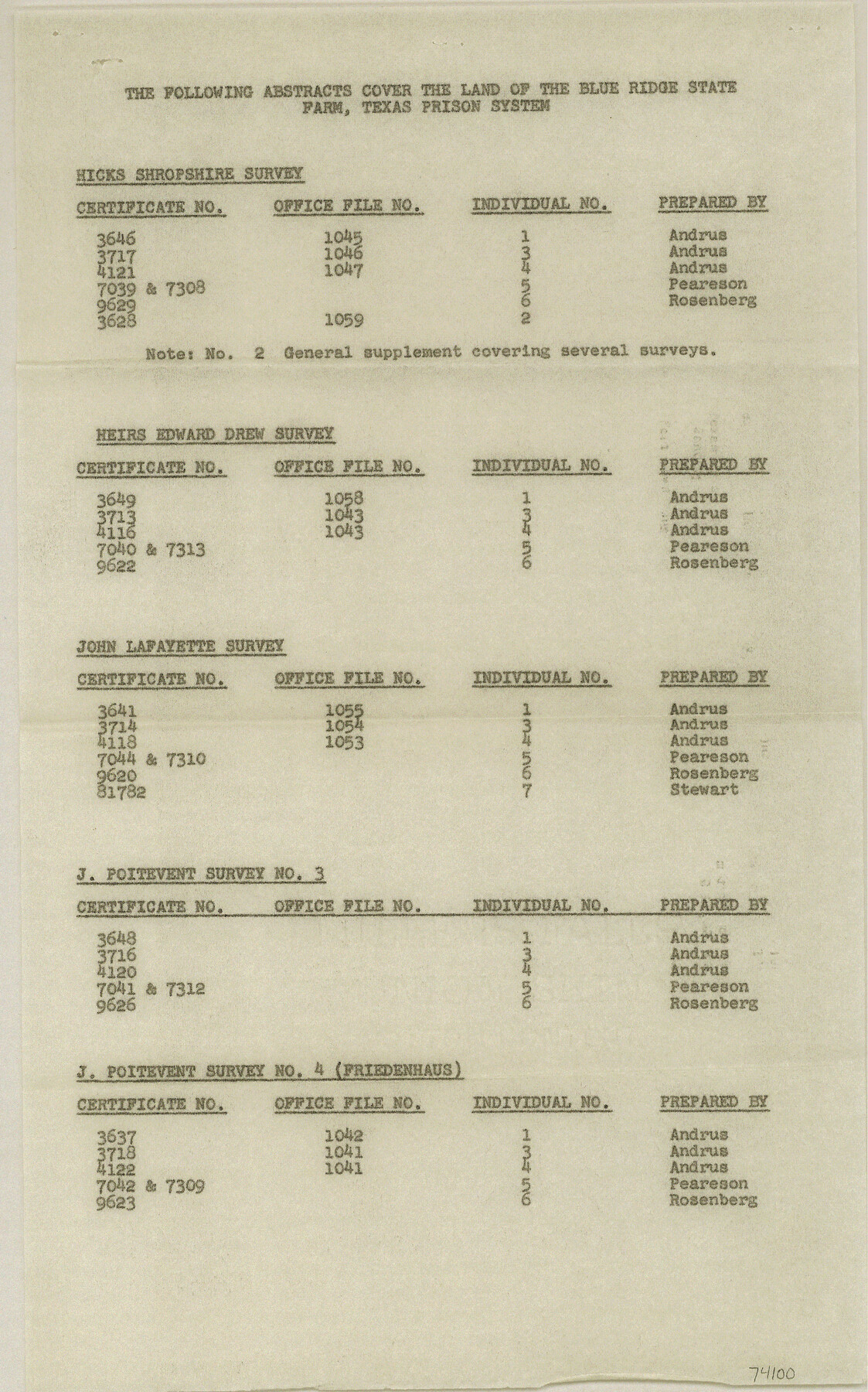
Abstracts covering the land of the Blue Ridge State Farm, Texas Prison System, Fort Bend County
-
Map/Doc
74100
-
Collection
General Map Collection
-
Object Dates
1957/1/16 (Creation Date)
1957/1/16 (File Date)
-
Subjects
Prison Farms
-
Height x Width
14.1 x 8.8 inches
35.8 x 22.4 cm
Part of: General Map Collection
Maverick County Working Sketch 7

Print $20.00
- Digital $50.00
Maverick County Working Sketch 7
1959
Size 22.4 x 21.0 inches
Map/Doc 70899
Cooke County Rolled Sketch 7

Print $20.00
- Digital $50.00
Cooke County Rolled Sketch 7
2002
Size 44.8 x 34.9 inches
Map/Doc 77525
Duval County Rolled Sketch 27

Print $40.00
- Digital $50.00
Duval County Rolled Sketch 27
Size 14.6 x 50.6 inches
Map/Doc 8814
McMullen County Working Sketch 62

Print $20.00
- Digital $50.00
McMullen County Working Sketch 62
2016
Size 24.1 x 36.1 inches
Map/Doc 94089
Map of the City of Aransas Pass

Print $20.00
- Digital $50.00
Map of the City of Aransas Pass
1905
Size 28.3 x 21.4 inches
Map/Doc 97266
Flight Mission No. CLL-1N, Frame 82, Willacy County

Print $20.00
- Digital $50.00
Flight Mission No. CLL-1N, Frame 82, Willacy County
1954
Size 18.3 x 22.1 inches
Map/Doc 87028
[Sketch for Mineral Application 16696-16697, Pecos River]
![76024, [Sketch for Mineral Application 16696-16697, Pecos River], General Map Collection](https://historictexasmaps.com/wmedia_w700/maps/76024.tif.jpg)
Print $40.00
- Digital $50.00
[Sketch for Mineral Application 16696-16697, Pecos River]
Size 44.0 x 126.6 inches
Map/Doc 76024
USGS Topographic: Texas-Oklahoma Denison Quadrangle

Print $20.00
- Digital $50.00
USGS Topographic: Texas-Oklahoma Denison Quadrangle
1901
Size 21.3 x 17.4 inches
Map/Doc 75108
Map of Brewster Co.

Print $20.00
- Digital $50.00
Map of Brewster Co.
Size 26.6 x 43.2 inches
Map/Doc 66725

Upton County Rolled Sketch 25

Print $20.00
- Digital $50.00
Upton County Rolled Sketch 25
1941
Size 33.2 x 34.5 inches
Map/Doc 10044
Harris County Working Sketch 105

Print $20.00
- Digital $50.00
Harris County Working Sketch 105
1980
Size 36.6 x 44.9 inches
Map/Doc 65997
You may also like
Map of the Missouri Pacific Railway, St. Louis, Iron Mountain and Southern R'y

Print $20.00
- Digital $50.00
Map of the Missouri Pacific Railway, St. Louis, Iron Mountain and Southern R'y
1894
Size 11.4 x 17.5 inches
Map/Doc 93950
Flight Mission No. BRE-1P, Frame 104, Nueces County

Print $20.00
- Digital $50.00
Flight Mission No. BRE-1P, Frame 104, Nueces County
1956
Size 18.4 x 22.2 inches
Map/Doc 86675
Panola County Rolled Sketch 4A

Print $40.00
- Digital $50.00
Panola County Rolled Sketch 4A
1953
Size 50.0 x 24.8 inches
Map/Doc 9677
Map of the State of Texas Showing Original Land Districts

Print $20.00
- Digital $50.00
Map of the State of Texas Showing Original Land Districts
1891
Size 43.7 x 43.3 inches
Map/Doc 73598
Hunt County Sketch File 34a

Print $4.00
- Digital $50.00
Hunt County Sketch File 34a
1873
Size 8.0 x 10.1 inches
Map/Doc 27146
Flight Mission No. CRE-2R, Frame 156, Jackson County

Print $20.00
- Digital $50.00
Flight Mission No. CRE-2R, Frame 156, Jackson County
1956
Size 16.2 x 16.1 inches
Map/Doc 85367
Map of Texas Gulf Coast and Continental Shelf showing Natural Gas Pipe Lines

Print $40.00
- Digital $50.00
Map of Texas Gulf Coast and Continental Shelf showing Natural Gas Pipe Lines
1983
Size 40.9 x 59.1 inches
Map/Doc 75969
Pecos County Sketch File 29b

Print $12.00
- Digital $50.00
Pecos County Sketch File 29b
1929
Size 14.3 x 8.8 inches
Map/Doc 33692
Pecos County Sketch File 30

Print $20.00
- Digital $50.00
Pecos County Sketch File 30
Size 28.9 x 22.0 inches
Map/Doc 12172
Rusk County Sketch File 39

Print $6.00
Rusk County Sketch File 39
1951
Size 11.3 x 8.9 inches
Map/Doc 35579
Harris County Sketch File E

Print $4.00
- Digital $50.00
Harris County Sketch File E
1860
Size 7.6 x 12.1 inches
Map/Doc 25315
Harrison County Boundary File 41 (10)

Print $10.00
- Digital $50.00
Harrison County Boundary File 41 (10)
Size 7.1 x 3.4 inches
Map/Doc 54418