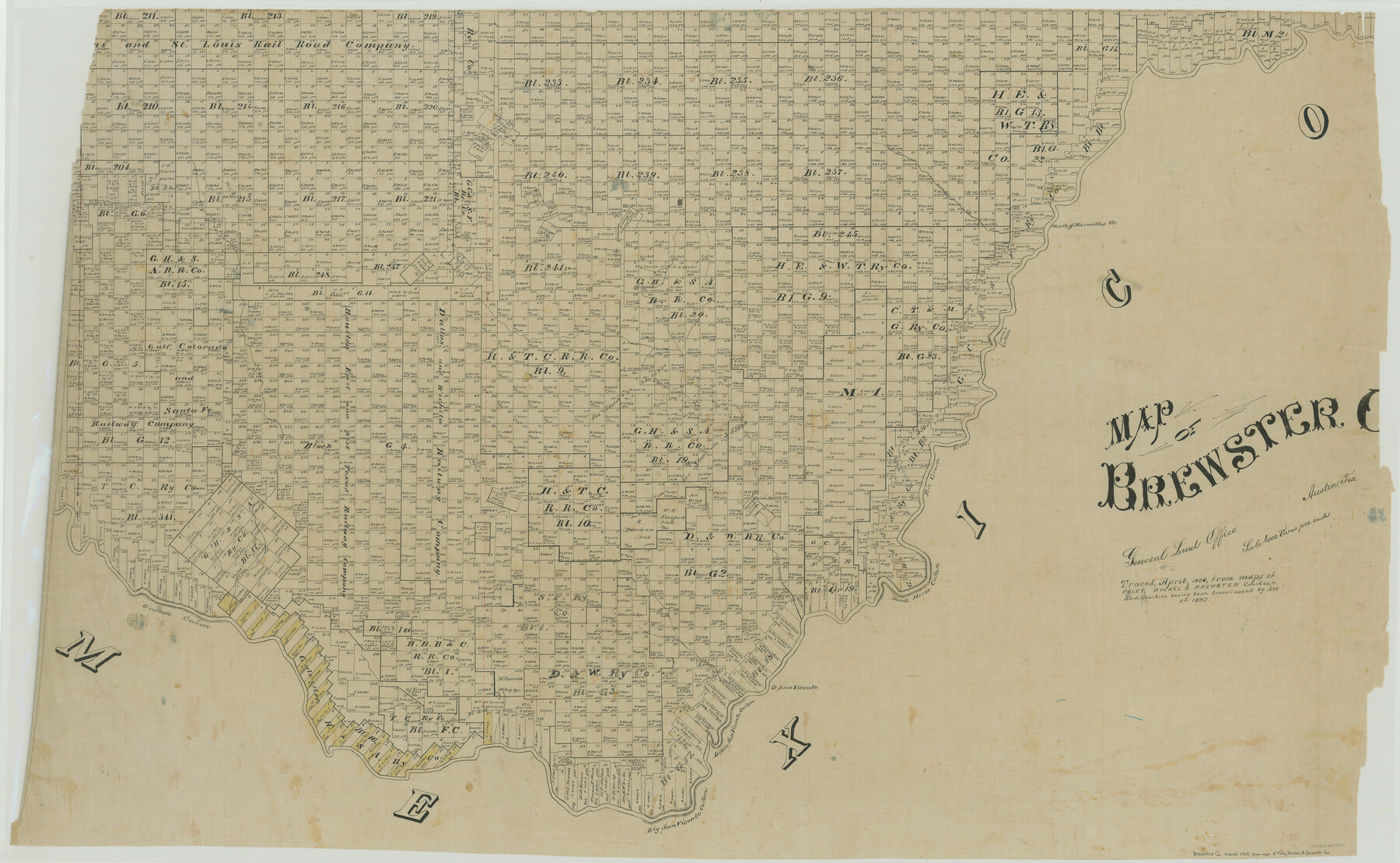
Map of Brewster Co.
-
Map/Doc
66725
-
Collection
General Map Collection
-
People and Organizations
Texas General Land Office (Publisher)
-
Counties
Brewster
-
Subjects
County
-
Height x Width
26.6 x 43.2 inches
67.6 x 109.7 cm
-
Comments
Traced in April 1900 from maps of Foley, Buchel and Brewster Counties. Said counties having been consolidated by Act of 1897.
Part of: General Map Collection
Live Oak County Working Sketch 29

Print $20.00
- Digital $50.00
Live Oak County Working Sketch 29
1983
Size 33.7 x 42.8 inches
Map/Doc 70614

Gonzales County Sketch File 2

Print $10.00
- Digital $50.00
Gonzales County Sketch File 2
Size 8.9 x 7.8 inches
Map/Doc 24357
Castro County Working Sketch 9

Print $20.00
- Digital $50.00
Castro County Working Sketch 9
1965
Size 47.1 x 42.7 inches
Map/Doc 68646
Newton County Working Sketch 29

Print $20.00
- Digital $50.00
Newton County Working Sketch 29
1955
Size 21.2 x 39.8 inches
Map/Doc 71275
Terrell County Working Sketch 7

Print $20.00
- Digital $50.00
Terrell County Working Sketch 7
1915
Size 42.2 x 31.3 inches
Map/Doc 62156
Map of Erath County

Print $40.00
- Digital $50.00
Map of Erath County
1896
Size 48.6 x 45.1 inches
Map/Doc 66821
[Right of Way Map, Belton Branch of the M.K.&T. RR.]
![64220, [Right of Way Map, Belton Branch of the M.K.&T. RR.], General Map Collection](https://historictexasmaps.com/wmedia_w700/maps/64220.tif.jpg)
Print $20.00
- Digital $50.00
[Right of Way Map, Belton Branch of the M.K.&T. RR.]
1896
Size 22.2 x 7.4 inches
Map/Doc 64220
Haskell County Boundary File 6

Print $40.00
- Digital $50.00
Haskell County Boundary File 6
Size 7.6 x 33.9 inches
Map/Doc 54582
Map of Llano County

Print $20.00
- Digital $50.00
Map of Llano County
1859
Size 28.6 x 21.7 inches
Map/Doc 3826
Ector County Rolled Sketch 13

Print $40.00
- Digital $50.00
Ector County Rolled Sketch 13
1957
Size 49.2 x 32.0 inches
Map/Doc 8841
Ward County Rolled Sketch 18

Print $20.00
- Digital $50.00
Ward County Rolled Sketch 18
1949
Size 31.6 x 34.0 inches
Map/Doc 10109
You may also like
Dimmit County Sketch File 58

Print $20.00
- Digital $50.00
Dimmit County Sketch File 58
1951
Size 18.0 x 9.8 inches
Map/Doc 11361
[Blk. Y2, B. & B. Blk. 5, T. T. Blk. T, North line of H. & G. N. Blk. 4]
![90140, [Blk. Y2, B. & B. Blk. 5, T. T. Blk. T, North line of H. & G. N. Blk. 4], Twichell Survey Records](https://historictexasmaps.com/wmedia_w700/maps/90140-1.tif.jpg)
Print $20.00
- Digital $50.00
[Blk. Y2, B. & B. Blk. 5, T. T. Blk. T, North line of H. & G. N. Blk. 4]
Size 18.8 x 23.7 inches
Map/Doc 90140
Leon County Working Sketch 28

Print $20.00
- Digital $50.00
Leon County Working Sketch 28
1971
Size 25.0 x 30.1 inches
Map/Doc 70427
Dawson County Boundary File 1

Print $48.00
- Digital $50.00
Dawson County Boundary File 1
Size 8.8 x 4.0 inches
Map/Doc 52314
Angelina County Working Sketch 13

Print $20.00
- Digital $50.00
Angelina County Working Sketch 13
1935
Size 30.8 x 35.4 inches
Map/Doc 67094
Culberson County Sketch File 18

Print $8.00
- Digital $50.00
Culberson County Sketch File 18
Size 14.3 x 8.8 inches
Map/Doc 20185
Leon County Working Sketch 31

Print $20.00
- Digital $50.00
Leon County Working Sketch 31
1974
Size 24.4 x 18.6 inches
Map/Doc 70430
Fractional Township No. 8 South Range No. 13 East of the Indian Meridian, Indian Territory

Print $20.00
- Digital $50.00
Fractional Township No. 8 South Range No. 13 East of the Indian Meridian, Indian Territory
1896
Size 19.1 x 24.3 inches
Map/Doc 75224
Crane County Map of Unsurveyed School Lands for Bob Reid's Application to Lease

Print $40.00
- Digital $50.00
Crane County Map of Unsurveyed School Lands for Bob Reid's Application to Lease
1946
Size 49.0 x 51.3 inches
Map/Doc 90466
Brazoria County Rolled Sketch 25

Print $40.00
- Digital $50.00
Brazoria County Rolled Sketch 25
1935
Size 50.8 x 33.5 inches
Map/Doc 8928
A Geographically Correct County Map of States Traversed by the St. Louis, Iron Mountain & Southern Railway and its Connections

Print $20.00
- Digital $50.00
A Geographically Correct County Map of States Traversed by the St. Louis, Iron Mountain & Southern Railway and its Connections
1877
Size 18.5 x 16.1 inches
Map/Doc 95782
Terrell County Working Sketch 54

Print $20.00
- Digital $50.00
Terrell County Working Sketch 54
1959
Size 25.2 x 42.9 inches
Map/Doc 62147