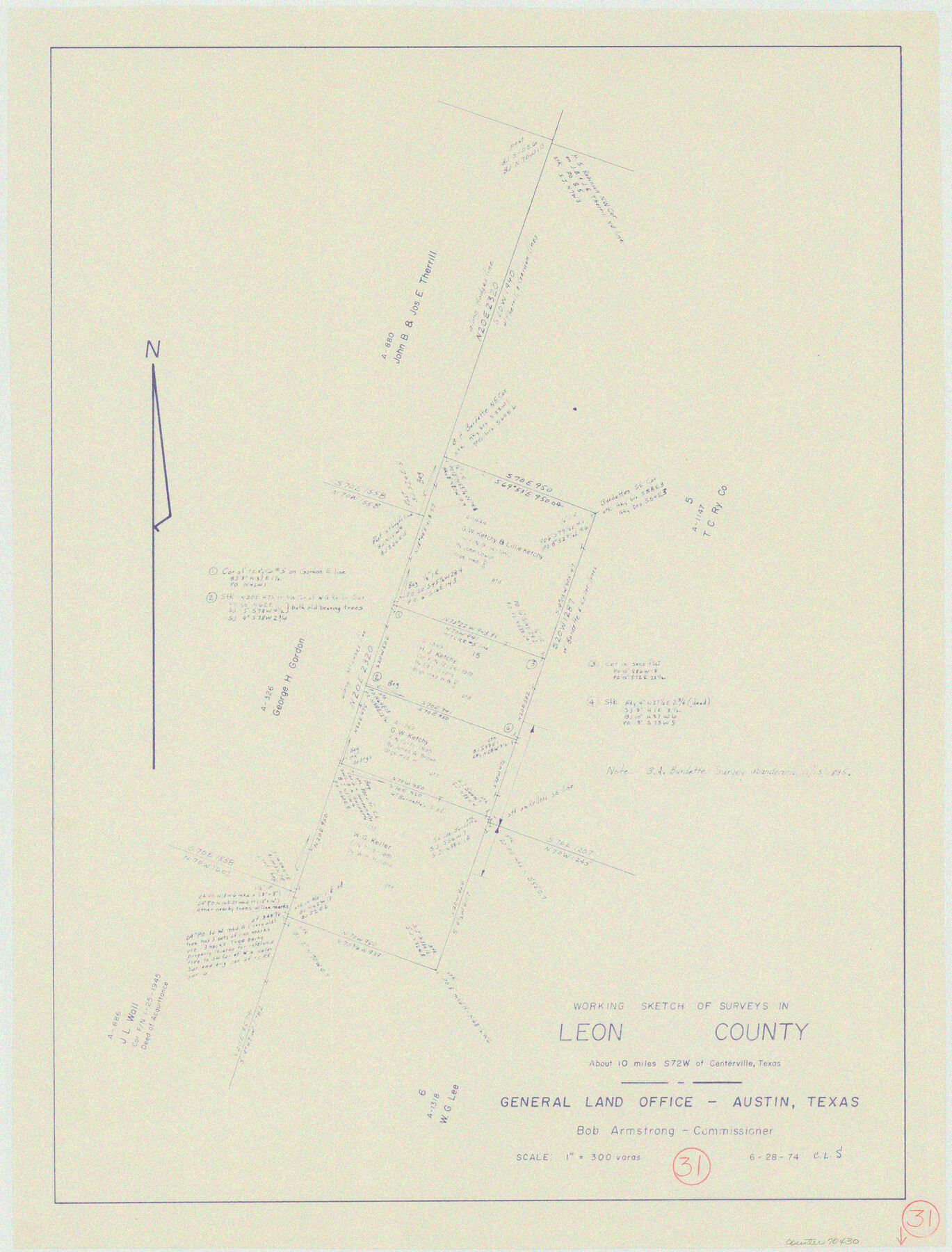
Leon County Working Sketch 31
-
Map/Doc
70430
-
Collection
General Map Collection
-
Object Dates
6/28/1974 (Creation Date)
-
People and Organizations
Crockett L. Slover (Draftsman)
-
Counties
Leon
-
Subjects
Surveying Working Sketch
-
Height x Width
24.4 x 18.6 inches
62.0 x 47.2 cm
-
Scale
1" = 300 varas
Part of: General Map Collection
Baylor County Sketch File 24

Print $6.00
- Digital $50.00
Baylor County Sketch File 24
1934
Size 13.9 x 8.8 inches
Map/Doc 14209
Trinity County Working Sketch 15

Print $20.00
- Digital $50.00
Trinity County Working Sketch 15
1974
Size 30.5 x 32.5 inches
Map/Doc 69464
Rio Grande Rectification Project, El Paso and Juarez Valley

Print $20.00
- Digital $50.00
Rio Grande Rectification Project, El Paso and Juarez Valley
1935
Size 10.7 x 29.4 inches
Map/Doc 60867
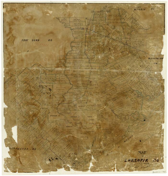
Map of Brazoria County
Print $20.00
- Digital $50.00
Map of Brazoria County
1883
Size 26.8 x 25.6 inches
Map/Doc 861
Red River County Working Sketch 42

Print $20.00
- Digital $50.00
Red River County Working Sketch 42
1968
Size 28.7 x 36.8 inches
Map/Doc 72025
Menard County Working Sketch 27

Print $20.00
- Digital $50.00
Menard County Working Sketch 27
1962
Size 38.2 x 43.8 inches
Map/Doc 70974
Presidio County Rolled Sketch 104

Print $20.00
- Digital $50.00
Presidio County Rolled Sketch 104
1948
Size 26.1 x 40.0 inches
Map/Doc 7386
Hopkins County Boundary File 1

Print $26.00
- Digital $50.00
Hopkins County Boundary File 1
Size 12.3 x 7.9 inches
Map/Doc 55044
Val Verde County Rolled Sketch 38

Print $20.00
- Digital $50.00
Val Verde County Rolled Sketch 38
Size 30.4 x 19.5 inches
Map/Doc 61781
Menard County Working Sketch 9

Print $20.00
- Digital $50.00
Menard County Working Sketch 9
1937
Size 22.9 x 22.5 inches
Map/Doc 70956
Newton County Sketch File O

Print $4.00
- Digital $50.00
Newton County Sketch File O
Size 6.8 x 8.3 inches
Map/Doc 32413
East Part of Brewster Co.

Print $40.00
- Digital $50.00
East Part of Brewster Co.
1952
Size 48.5 x 30.7 inches
Map/Doc 73087
You may also like

Loving County Sketch File 7

Print $2.00
- Digital $50.00
Loving County Sketch File 7
1977
Size 12.1 x 8.8 inches
Map/Doc 30417
Ector County Rolled Sketch 9

Print $20.00
- Digital $50.00
Ector County Rolled Sketch 9
1940
Size 39.1 x 43.0 inches
Map/Doc 8837
Culberson County Working Sketch 25

Print $40.00
- Digital $50.00
Culberson County Working Sketch 25
1951
Size 36.9 x 52.5 inches
Map/Doc 62343
Atascosa County Sketch File 8

Print $6.00
- Digital $50.00
Atascosa County Sketch File 8
1857
Size 8.7 x 7.7 inches
Map/Doc 13758
Hutchinson County Sketch File 3

Print $4.00
- Digital $50.00
Hutchinson County Sketch File 3
Size 8.2 x 12.8 inches
Map/Doc 27177
[Abstract Numbering Register - Real through Zavala]
![82968, [Abstract Numbering Register - Real through Zavala], General Map Collection](https://historictexasmaps.com/wmedia_w700/pdf_converted_jpg/qi_pdf_thumbnail_30615.jpg)
[Abstract Numbering Register - Real through Zavala]
Map/Doc 82968
[Northeast part of County]
![89957, [Northeast part of County], Twichell Survey Records](https://historictexasmaps.com/wmedia_w700/maps/89957-1.tif.jpg)
Print $20.00
- Digital $50.00
[Northeast part of County]
Size 37.1 x 42.9 inches
Map/Doc 89957
Leon County Working Sketch 54

Print $20.00
- Digital $50.00
Leon County Working Sketch 54
1982
Size 34.0 x 42.0 inches
Map/Doc 70454
Flight Mission No. DQN-2K, Frame 157, Calhoun County

Print $20.00
- Digital $50.00
Flight Mission No. DQN-2K, Frame 157, Calhoun County
1953
Size 18.5 x 22.2 inches
Map/Doc 84319
Palo Pinto County Sketch File 24

Print $20.00
- Digital $50.00
Palo Pinto County Sketch File 24
Size 21.0 x 32.8 inches
Map/Doc 12136
Jack County Working Sketch Graphic Index

Print $20.00
- Digital $50.00
Jack County Working Sketch Graphic Index
1925
Size 45.4 x 37.3 inches
Map/Doc 76589