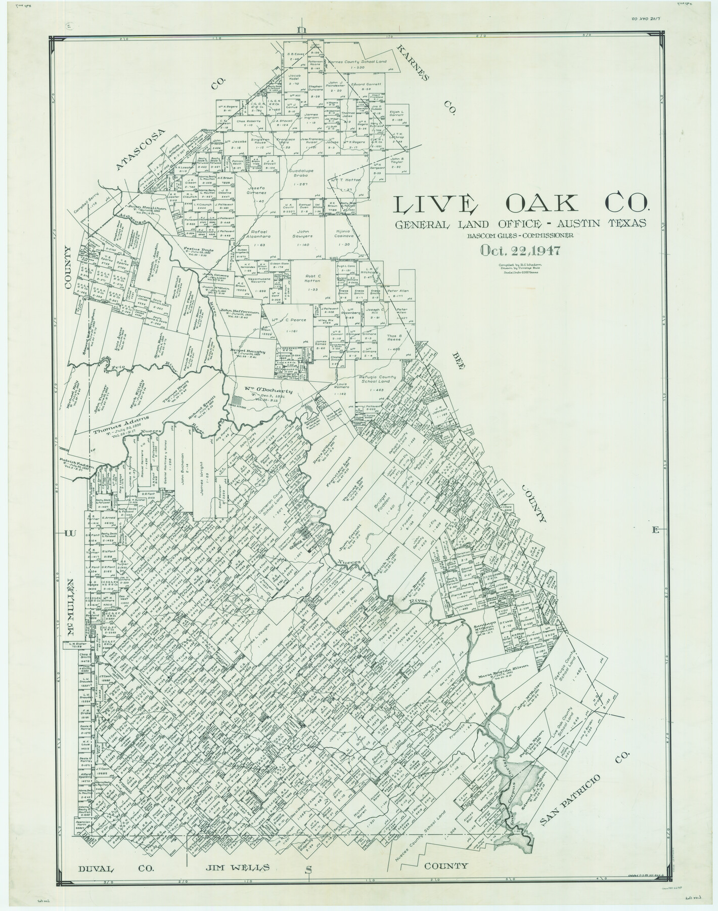
Live Oak Co.
-
Map/Doc
66907
-
Collection
General Map Collection
-
Object Dates
1947/10/22 (Creation Date)
-
People and Organizations
Texas General Land Office (Publisher)
Tommye Buie (Draftsman)
Bascom Giles (GLO Commissioner)
R.C. Wisdom (Compiler)
-
Counties
Live Oak
-
Subjects
County
-
Height x Width
54.3 x 42.8 inches
137.9 x 108.7 cm
Part of: General Map Collection
Flight Mission No. DAG-21K, Frame 100, Matagorda County

Print $20.00
- Digital $50.00
Flight Mission No. DAG-21K, Frame 100, Matagorda County
1952
Size 18.6 x 22.3 inches
Map/Doc 86429
Harris County Working Sketch 87

Print $20.00
- Digital $50.00
Harris County Working Sketch 87
1972
Size 34.1 x 31.0 inches
Map/Doc 65979
Gonzales County Working Sketch 10

Print $20.00
- Digital $50.00
Gonzales County Working Sketch 10
1981
Size 18.9 x 14.7 inches
Map/Doc 63226
Dallas County

Print $20.00
- Digital $50.00
Dallas County
1942
Size 45.5 x 38.0 inches
Map/Doc 16954
Flight Mission No. BRA-8M, Frame 65, Jefferson County

Print $20.00
- Digital $50.00
Flight Mission No. BRA-8M, Frame 65, Jefferson County
1953
Size 18.6 x 22.4 inches
Map/Doc 85585
Harbor of Brazos Santiago, Texas

Print $20.00
- Digital $50.00
Harbor of Brazos Santiago, Texas
1887
Size 27.2 x 18.4 inches
Map/Doc 72996
Uvalde County Working Sketch 5

Print $20.00
- Digital $50.00
Uvalde County Working Sketch 5
1927
Size 13.4 x 18.0 inches
Map/Doc 72075
Starr County Rolled Sketch 12

Print $20.00
- Digital $50.00
Starr County Rolled Sketch 12
1912
Size 19.5 x 15.5 inches
Map/Doc 7799
Outer Continental Shelf Leasing Maps (Louisiana Offshore Operations)

Print $20.00
- Digital $50.00
Outer Continental Shelf Leasing Maps (Louisiana Offshore Operations)
1955
Size 9.7 x 11.3 inches
Map/Doc 76089
Glasscock County Rolled Sketch 2

Print $20.00
- Digital $50.00
Glasscock County Rolled Sketch 2
1906
Size 19.6 x 14.8 inches
Map/Doc 6013
Lavaca County Working Sketch 14

Print $20.00
- Digital $50.00
Lavaca County Working Sketch 14
1962
Size 28.4 x 29.7 inches
Map/Doc 70367
Matagorda County Working Sketch 27

Print $20.00
- Digital $50.00
Matagorda County Working Sketch 27
1979
Size 19.0 x 14.3 inches
Map/Doc 70885
You may also like
Harris County Working Sketch 14

Print $20.00
- Digital $50.00
Harris County Working Sketch 14
Size 18.9 x 17.4 inches
Map/Doc 65906
[Unidentified Railroad through Denton and Dallas County]
![64774, [Unidentified Railroad through Denton and Dallas County], General Map Collection](https://historictexasmaps.com/wmedia_w700/maps/64774.tif.jpg)
Print $40.00
- Digital $50.00
[Unidentified Railroad through Denton and Dallas County]
Size 6.8 x 121.3 inches
Map/Doc 64774
Crockett County Rolled Sketch 88G

Print $40.00
- Digital $50.00
Crockett County Rolled Sketch 88G
1973
Size 42.7 x 57.3 inches
Map/Doc 8732
Deaf Smith County, Texas

Print $20.00
- Digital $50.00
Deaf Smith County, Texas
1880
Size 22.9 x 25.6 inches
Map/Doc 678

Starr County Sketch File 32A

Print $26.00
- Digital $50.00
Starr County Sketch File 32A
1938
Size 14.2 x 8.6 inches
Map/Doc 36967
Cottle County Sketch File 11

Print $40.00
- Digital $50.00
Cottle County Sketch File 11
Size 12.9 x 13.3 inches
Map/Doc 19489
Right of Way Location Map, San Antonio & Aransas Pass, Station 656…

Print $4.00
- Digital $50.00
Right of Way Location Map, San Antonio & Aransas Pass, Station 656…
1919
Size 11.8 x 18.6 inches
Map/Doc 62567
Kimble County Working Sketch 48

Print $20.00
- Digital $50.00
Kimble County Working Sketch 48
1951
Size 23.2 x 22.1 inches
Map/Doc 70116
[Gunter & Munson, Maddox Bros. & Anderson Block O]
![91946, [Gunter & Munson, Maddox Bros. & Anderson Block O], Twichell Survey Records](https://historictexasmaps.com/wmedia_w700/maps/91946-1.tif.jpg)
Print $20.00
- Digital $50.00
[Gunter & Munson, Maddox Bros. & Anderson Block O]
Size 25.8 x 40.6 inches
Map/Doc 91946
Jack County Working Sketch 17

Print $20.00
- Digital $50.00
Jack County Working Sketch 17
1982
Size 25.9 x 27.4 inches
Map/Doc 66443
Brazos River, Brazos River Sheet 6

Print $4.00
- Digital $50.00
Brazos River, Brazos River Sheet 6
1926
Size 29.0 x 24.3 inches
Map/Doc 65299