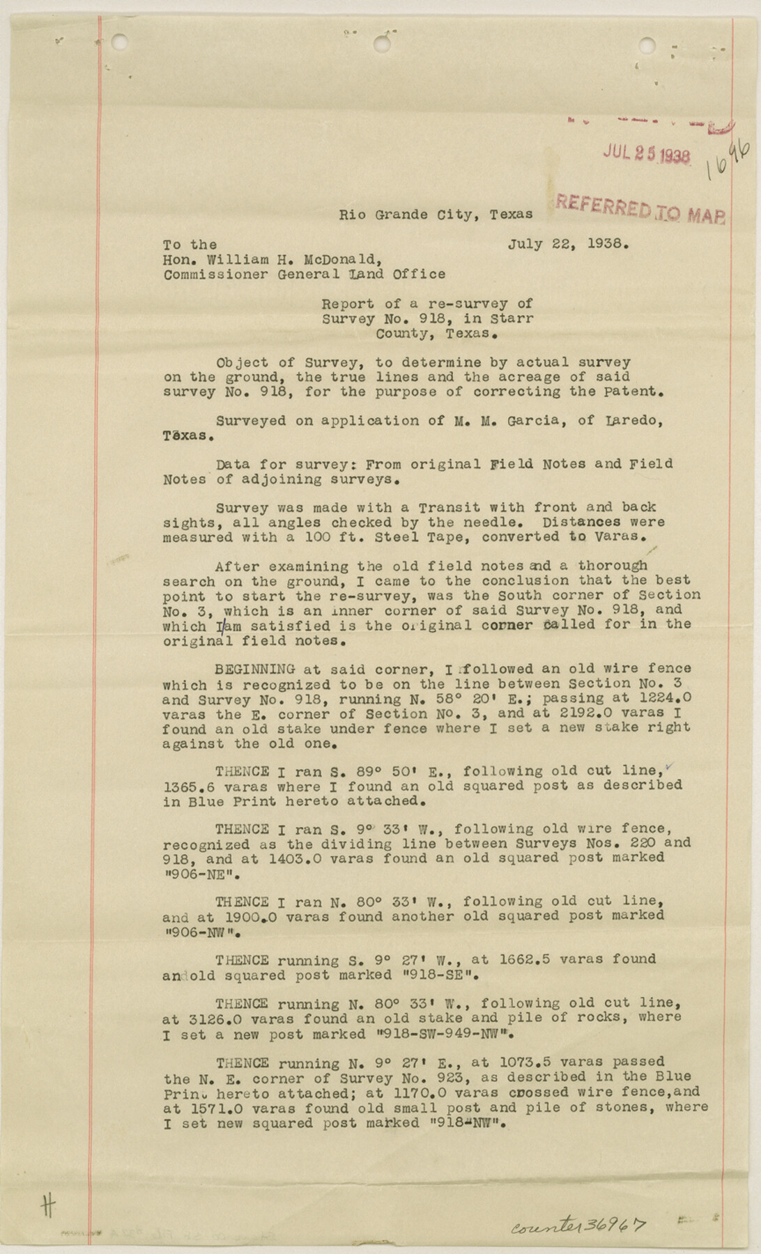
Starr County Sketch File 32A
[Report and sketch of a resurvey of survey 918]
-
Map/Doc
36967
-
Collection
General Map Collection
-
Object Dates
1938 (Creation Date)
7/25/1938 (File Date)
-
People and Organizations
Demetrio Garcia (Surveyor/Engineer)
-
Counties
Starr
-
Subjects
Surveying Sketch File
-
Height x Width
14.2 x 8.6 inches
36.1 x 21.8 cm
-
Medium
multi-page, multi-format
-
Scale
1" = 500 varas
Part of: General Map Collection

Flight Mission No. CRC-3R, Frame 13, Chambers County

Print $20.00
- Digital $50.00
Flight Mission No. CRC-3R, Frame 13, Chambers County
1956
Size 18.5 x 22.3 inches
Map/Doc 84787

Navarro County Sketch File 4

Print $6.00
- Digital $50.00
Navarro County Sketch File 4
1852
Size 7.5 x 7.2 inches
Map/Doc 32304
United States - Gulf Coast - Galveston to Rio Grande

Print $20.00
- Digital $50.00
United States - Gulf Coast - Galveston to Rio Grande
Size 27.8 x 18.1 inches
Map/Doc 72740
El Paso County Working Sketch 6

Print $20.00
- Digital $50.00
El Paso County Working Sketch 6
1928
Size 25.4 x 16.7 inches
Map/Doc 69028
Shelby County Sketch File 13

Print $2.00
- Digital $50.00
Shelby County Sketch File 13
1859
Size 8.2 x 12.8 inches
Map/Doc 36621
Tom Green County Sketch File 14

Print $20.00
- Digital $50.00
Tom Green County Sketch File 14
Size 34.8 x 45.7 inches
Map/Doc 10401

Jasper County

Print $40.00
- Digital $50.00
Jasper County
1946
Size 49.8 x 43.9 inches
Map/Doc 95542
Panola County Working Sketch 24

Print $20.00
- Digital $50.00
Panola County Working Sketch 24
1957
Map/Doc 71433
Trinity River, Daugherty Lake Sheet/East Fork of Trinity River

Print $20.00
- Digital $50.00
Trinity River, Daugherty Lake Sheet/East Fork of Trinity River
1920
Size 41.9 x 30.1 inches
Map/Doc 65191
You may also like
Map of University Land in Shackelford and Callahan Counties

Print $20.00
- Digital $50.00
Map of University Land in Shackelford and Callahan Counties
1905
Size 33.4 x 25.3 inches
Map/Doc 2435
Karte des Staates, Texas

Print $20.00
Karte des Staates, Texas
1851
Size 27.2 x 30.1 inches
Map/Doc 76262
[Gonzales District]
![16837, [Gonzales District], General Map Collection](https://historictexasmaps.com/wmedia_w700/maps/16837.tif.jpg)
Print $20.00
- Digital $50.00
[Gonzales District]
1840
Size 42.8 x 37.0 inches
Map/Doc 16837
Nueces County Sketch File 56

Print $113.00
- Digital $50.00
Nueces County Sketch File 56
1973
Size 10.1 x 9.3 inches
Map/Doc 32874
Harris County Rolled Sketch 59

Print $20.00
- Digital $50.00
Harris County Rolled Sketch 59
1937
Size 18.7 x 20.9 inches
Map/Doc 6105

Frio County Sketch File 3

Print $4.00
- Digital $50.00
Frio County Sketch File 3
1854
Size 8.5 x 3.6 inches
Map/Doc 23109
Terrell County Working Sketch 59

Print $20.00
- Digital $50.00
Terrell County Working Sketch 59
1961
Size 20.3 x 21.8 inches
Map/Doc 69580
Witt Addition, Subdivision out of Section 6, Block E, City of Lubbock

Print $20.00
- Digital $50.00
Witt Addition, Subdivision out of Section 6, Block E, City of Lubbock
1950
Size 9.5 x 31.4 inches
Map/Doc 92738
Randall County Rolled Sketch 1

Print $20.00
- Digital $50.00
Randall County Rolled Sketch 1
1889
Size 21.1 x 35.1 inches
Map/Doc 9807
Parker County Sketch File A

Print $4.00
- Digital $50.00
Parker County Sketch File A
1857
Size 7.9 x 8.2 inches
Map/Doc 33507
Fort Worth, Tex. "The Queen of the Prairies," County Seat of Tarrant County

Print $20.00
Fort Worth, Tex. "The Queen of the Prairies," County Seat of Tarrant County
1886
Size 26.0 x 33.3 inches
Map/Doc 89082