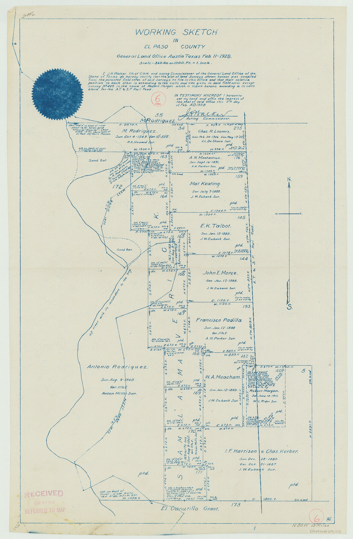
El Paso County Working Sketch 6
-
Map/Doc
69028
-
Collection
General Map Collection
-
Object Dates
2/11/1928 (Creation Date)
-
Counties
El Paso
-
Subjects
Surveying Working Sketch
-
Height x Width
25.4 x 16.7 inches
64.5 x 42.4 cm
-
Scale
1" = 360 varas
Part of: General Map Collection
Culberson County Sketch File 5a

Print $44.00
- Digital $50.00
Culberson County Sketch File 5a
Size 14.2 x 8.8 inches
Map/Doc 20169
Starr County Rolled Sketch 43

Print $20.00
- Digital $50.00
Starr County Rolled Sketch 43
1982
Size 36.1 x 30.9 inches
Map/Doc 7836
Travis County Rolled Sketch 18

Print $20.00
- Digital $50.00
Travis County Rolled Sketch 18
1940
Size 28.8 x 21.1 inches
Map/Doc 8020
Flight Mission No. BRA-16M, Frame 112, Jefferson County

Print $20.00
- Digital $50.00
Flight Mission No. BRA-16M, Frame 112, Jefferson County
1953
Size 18.6 x 22.2 inches
Map/Doc 85722
[Cotton Belt, St. Louis Southwestern Railway of Texas, Alignment through Smith County]
![64374, [Cotton Belt, St. Louis Southwestern Railway of Texas, Alignment through Smith County], General Map Collection](https://historictexasmaps.com/wmedia_w700/maps/64374.tif.jpg)
Print $20.00
- Digital $50.00
[Cotton Belt, St. Louis Southwestern Railway of Texas, Alignment through Smith County]
1903
Size 21.5 x 29.3 inches
Map/Doc 64374
Blanco County Sketch File 27

Print $6.00
- Digital $50.00
Blanco County Sketch File 27
1888
Size 14.1 x 11.2 inches
Map/Doc 14621
Flight Mission No. CUG-3P, Frame 46, Kleberg County

Print $20.00
- Digital $50.00
Flight Mission No. CUG-3P, Frame 46, Kleberg County
1956
Size 18.5 x 22.2 inches
Map/Doc 86251
Travis County Appraisal District Plat Map 3_1100

Print $20.00
- Digital $50.00
Travis County Appraisal District Plat Map 3_1100
Size 21.5 x 26.4 inches
Map/Doc 94212
Flight Mission No. BQY-15M, Frame 9, Harris County

Print $20.00
- Digital $50.00
Flight Mission No. BQY-15M, Frame 9, Harris County
1953
Size 18.6 x 22.2 inches
Map/Doc 85307
Tarrant County Sketch File 17

Print $8.00
- Digital $50.00
Tarrant County Sketch File 17
1860
Size 8.3 x 8.1 inches
Map/Doc 37716

Flight Mission No. CRC-3R, Frame 38, Chambers County

Print $20.00
- Digital $50.00
Flight Mission No. CRC-3R, Frame 38, Chambers County
1956
Size 18.7 x 22.4 inches
Map/Doc 84811
You may also like
Andrews County Working Sketch 24

Print $40.00
- Digital $50.00
Andrews County Working Sketch 24
1980
Size 55.5 x 37.4 inches
Map/Doc 67070
Flight Mission No. BRA-8M, Frame 143, Jefferson County

Print $20.00
- Digital $50.00
Flight Mission No. BRA-8M, Frame 143, Jefferson County
1953
Size 18.9 x 22.5 inches
Map/Doc 85635
Map of Hamilton County

Print $20.00
- Digital $50.00
Map of Hamilton County
1872
Size 14.9 x 21.9 inches
Map/Doc 4556
Galveston County Sketch File 41

Print $7.00
- Digital $50.00
Galveston County Sketch File 41
Size 11.3 x 8.9 inches
Map/Doc 23451
Flight Mission No. BRE-2G, Frame 118, Nueces County

Print $20.00
- Digital $50.00
Flight Mission No. BRE-2G, Frame 118, Nueces County
1950
Size 18.4 x 18.2 inches
Map/Doc 86623

No. 3 Chart of Channel connecting Corpus Christi Bay with Aransas Bay, Texas

Print $20.00
- Digital $50.00
No. 3 Chart of Channel connecting Corpus Christi Bay with Aransas Bay, Texas
1878
Size 18.3 x 27.9 inches
Map/Doc 72783
Grimes County Working Sketch 18

Print $20.00
- Digital $50.00
Grimes County Working Sketch 18
1990
Size 33.1 x 42.5 inches
Map/Doc 63309
Terrell County Working Sketch 3a

Print $20.00
- Digital $50.00
Terrell County Working Sketch 3a
1912
Size 26.1 x 21.2 inches
Map/Doc 62152
Terrell County Working Sketch 41

Print $20.00
- Digital $50.00
Terrell County Working Sketch 41
1957
Size 29.1 x 38.2 inches
Map/Doc 62134
Chambers County Sketch File 2

Print $8.00
- Digital $50.00
Chambers County Sketch File 2
Size 13.4 x 10.5 inches
Map/Doc 17518
Culberson County Rolled Sketch 43A

Print $20.00
- Digital $50.00
Culberson County Rolled Sketch 43A
1947
Size 21.7 x 37.2 inches
Map/Doc 5665