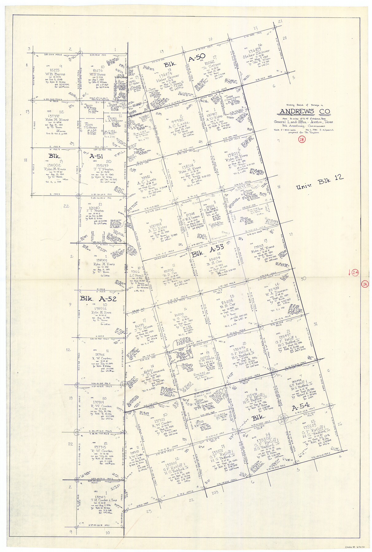
Andrews County Working Sketch 24
-
Map/Doc
67070
-
Collection
General Map Collection
-
Object Dates
2/6/1980 (Creation Date)
-
People and Organizations
Bob Armstrong (GLO Commissioner)
Joan Kilpatrick (Draftsman)
-
Counties
Andrews
-
Subjects
Surveying Working Sketch
-
Height x Width
55.5 x 37.4 inches
141.0 x 95.0 cm
-
Scale
1" = 400 varas
-
Comments
Surveys located about 36 miles South 72 degrees West of Andrews, Texas.
Part of: General Map Collection
Eastland County Working Sketch 31

Print $20.00
- Digital $50.00
Eastland County Working Sketch 31
1955
Size 33.9 x 33.9 inches
Map/Doc 68812
Nueces County Sketch File 60

Print $14.00
- Digital $50.00
Nueces County Sketch File 60
1940
Size 11.1 x 8.8 inches
Map/Doc 32962
Hays County Working Sketch 10

Print $20.00
- Digital $50.00
Hays County Working Sketch 10
1949
Size 23.4 x 25.8 inches
Map/Doc 66084
Dickens County Sketch File H1

Print $20.00
- Digital $50.00
Dickens County Sketch File H1
1902
Size 16.7 x 15.1 inches
Map/Doc 11336
Hunt County Sketch File 29

Print $4.00
- Digital $50.00
Hunt County Sketch File 29
Size 7.4 x 7.8 inches
Map/Doc 27130
Matagorda County Sketch File 47

Print $68.00
- Digital $50.00
Matagorda County Sketch File 47
Size 11.2 x 8.6 inches
Map/Doc 30976
Martin County

Print $20.00
- Digital $50.00
Martin County
1933
Size 43.8 x 38.9 inches
Map/Doc 73230
Motley County Sketch File 4 (S)

Print $4.00
- Digital $50.00
Motley County Sketch File 4 (S)
Size 12.9 x 8.4 inches
Map/Doc 32143
Chambers County Sketch File 2

Print $8.00
- Digital $50.00
Chambers County Sketch File 2
Size 13.4 x 10.5 inches
Map/Doc 17518
Oldham County Boundary File 1b

Print $48.00
- Digital $50.00
Oldham County Boundary File 1b
Size 14.0 x 8.5 inches
Map/Doc 57747
Shelby County Sketch File 20

Print $20.00
- Digital $50.00
Shelby County Sketch File 20
1879
Size 18.3 x 34.6 inches
Map/Doc 12319
Bandera County Working Sketch 21

Print $20.00
- Digital $50.00
Bandera County Working Sketch 21
1948
Size 21.1 x 16.7 inches
Map/Doc 67617
You may also like
Map of Hale County

Print $20.00
- Digital $50.00
Map of Hale County
1900
Size 47.8 x 38.6 inches
Map/Doc 66847
Hardin County Working Sketch 44

Print $40.00
- Digital $50.00
Hardin County Working Sketch 44
1954
Size 53.1 x 39.5 inches
Map/Doc 69764
[Sketch for Mineral Application 24072, San Jacinto River]
![65585, [Sketch for Mineral Application 24072, San Jacinto River], General Map Collection](https://historictexasmaps.com/wmedia_w700/maps/65585.tif.jpg)
Print $20.00
- Digital $50.00
[Sketch for Mineral Application 24072, San Jacinto River]
1929
Size 21.7 x 11.1 inches
Map/Doc 65585
Presidio County Working Sketch 133

Print $20.00
- Digital $50.00
Presidio County Working Sketch 133
1989
Size 31.7 x 42.8 inches
Map/Doc 71811
Jim Wells County Working Sketch 11

Print $20.00
- Digital $50.00
Jim Wells County Working Sketch 11
1953
Size 20.4 x 22.6 inches
Map/Doc 66609
Harrison County Sketch File 6

Print $4.00
- Digital $50.00
Harrison County Sketch File 6
Size 12.9 x 8.1 inches
Map/Doc 26044
Dimmit County Working Sketch Graphic Index - sheet A

Print $40.00
- Digital $50.00
Dimmit County Working Sketch Graphic Index - sheet A
1976
Size 42.0 x 49.7 inches
Map/Doc 76524
Gulf of Mexico

Print $20.00
- Digital $50.00
Gulf of Mexico
1961
Size 36.6 x 43.3 inches
Map/Doc 73551
El Paso County Rolled Sketch 51

Print $40.00
- Digital $50.00
El Paso County Rolled Sketch 51
Size 42.9 x 75.3 inches
Map/Doc 8877
Map of the Missouri Pacific Railway, St. Louis, Iron Mountain and Southern R'y

Print $20.00
- Digital $50.00
Map of the Missouri Pacific Railway, St. Louis, Iron Mountain and Southern R'y
1894
Size 11.4 x 17.5 inches
Map/Doc 93950
Webb County Rolled Sketch 71

Print $20.00
- Digital $50.00
Webb County Rolled Sketch 71
Size 24.2 x 18.5 inches
Map/Doc 8218
Chambers County Rolled Sketch 29

Print $20.00
- Digital $50.00
Chambers County Rolled Sketch 29
1951
Size 24.2 x 44.4 inches
Map/Doc 5429