Zapata County Rolled Sketch 28

Print $20.00
- Digital $50.00
Zapata County Rolled Sketch 28
Size: 35.5 x 35.3 inches
10174
Starr County Rolled Sketch 38

Print $40.00
- Digital $50.00
Starr County Rolled Sketch 38
1944
Size: 97.9 x 25.0 inches
10297
Starr County Sketch File 6

Print $20.00
- Digital $50.00
Starr County Sketch File 6
Size: 43.4 x 36.7 inches
10605
Starr County Sketch File 18

Print $20.00
- Digital $50.00
Starr County Sketch File 18
1880
Size: 38.2 x 25.1 inches
10606
Starr County Sketch File 26

Print $20.00
- Digital $50.00
Starr County Sketch File 26
1923
Size: 31.7 x 27.2 inches
10607
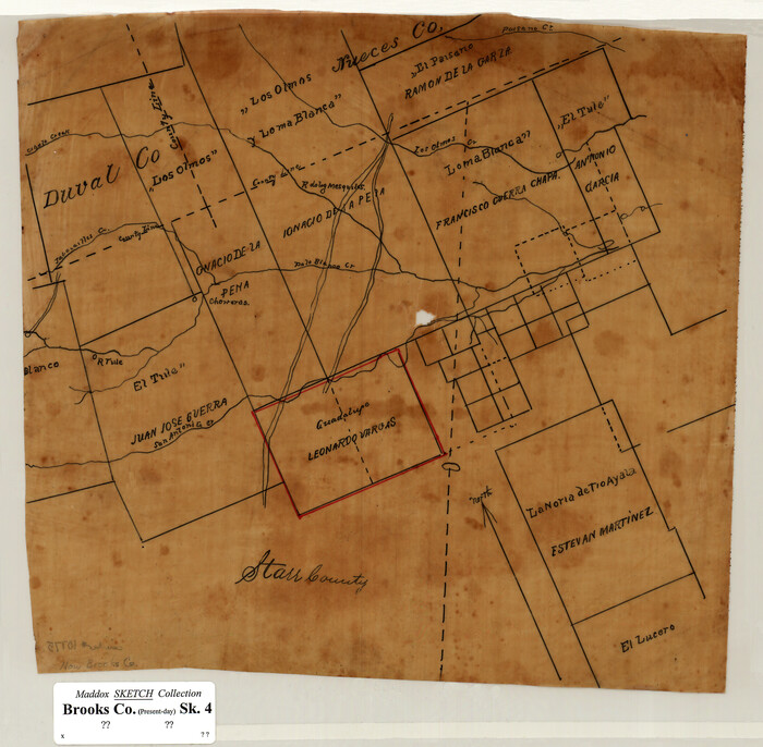
[Sketch of Surveys in Brooks County, Texas]
Print $20.00
- Digital $50.00
[Sketch of Surveys in Brooks County, Texas]
Size: 12.1 x 12.4 inches
10775
Hidalgo County Sketch File 10

Print $20.00
- Digital $50.00
Hidalgo County Sketch File 10
1911
Size: 16.3 x 34.8 inches
11762
Hidalgo County Sketch File 14

Print $20.00
- Digital $50.00
Hidalgo County Sketch File 14
Size: 29.6 x 24.5 inches
11764
Jim Hogg County Sketch File 1

Print $20.00
- Digital $50.00
Jim Hogg County Sketch File 1
1931
Size: 18.2 x 26.7 inches
11883
Starr County Sketch File 7

Print $20.00
- Digital $50.00
Starr County Sketch File 7
Size: 25.4 x 20.8 inches
12326
Starr County Sketch File 12

Print $20.00
- Digital $50.00
Starr County Sketch File 12
1886
Size: 16.2 x 23.7 inches
12328
Starr County Sketch File 13

Print $20.00
- Digital $50.00
Starr County Sketch File 13
1886
Size: 12.4 x 19.5 inches
12329
Starr County Sketch File 19

Print $20.00
- Digital $50.00
Starr County Sketch File 19
1887
Size: 22.6 x 22.0 inches
12330
Starr County Sketch File 22

Print $20.00
- Digital $50.00
Starr County Sketch File 22
1922
Size: 16.4 x 35.9 inches
12331
Starr County Sketch File 24

Print $20.00
- Digital $50.00
Starr County Sketch File 24
1922
Size: 15.7 x 19.5 inches
12332
Starr County Sketch File 27

Print $20.00
- Digital $50.00
Starr County Sketch File 27
1930
Size: 22.2 x 34.0 inches
12333
Starr County Sketch File 30A

Print $20.00
- Digital $50.00
Starr County Sketch File 30A
1935
Size: 21.2 x 23.6 inches
12334
Starr County Sketch File 31A

Print $20.00
- Digital $50.00
Starr County Sketch File 31A
1936
Size: 24.5 x 13.3 inches
12335
Starr County Sketch File 32B

Print $20.00
- Digital $50.00
Starr County Sketch File 32B
1938
Size: 19.9 x 21.5 inches
12336
Starr County Sketch File 34

Print $20.00
- Digital $50.00
Starr County Sketch File 34
1939
Size: 15.8 x 17.6 inches
12337
Starr County Sketch File 39

Print $20.00
- Digital $50.00
Starr County Sketch File 39
1940
Size: 22.9 x 22.1 inches
12339
Starr County Sketch File 41

Print $20.00
- Digital $50.00
Starr County Sketch File 41
1941
Size: 26.6 x 31.1 inches
12340
Starr County Sketch File 42

Print $20.00
- Digital $50.00
Starr County Sketch File 42
1941
Size: 19.0 x 21.6 inches
12341
Starr County Sketch File 46

Print $20.00
- Digital $50.00
Starr County Sketch File 46
1949
Size: 23.3 x 26.6 inches
12343
Starr County Sketch File 46 1/2

Print $20.00
- Digital $50.00
Starr County Sketch File 46 1/2
1978
Size: 17.9 x 17.2 inches
12344
Starr County Sketch File 48

Print $20.00
- Digital $50.00
Starr County Sketch File 48
1950
Size: 22.3 x 10.8 inches
12345
Starr County Sketch File 49

Print $20.00
- Digital $50.00
Starr County Sketch File 49
1951
Size: 24.9 x 17.2 inches
12346
Zapata County Sketch File 5

Print $20.00
- Digital $50.00
Zapata County Sketch File 5
1886
Size: 15.4 x 16.9 inches
12719
Zapata County Sketch File 19

Print $20.00
- Digital $50.00
Zapata County Sketch File 19
1957
Size: 23.5 x 13.2 inches
12724
Zapata County Rolled Sketch 28
Print $20.00
- Digital $50.00
Zapata County Rolled Sketch 28
-
Size
35.5 x 35.3 inches
-
Map/Doc
10174
Starr County Rolled Sketch 38
Print $40.00
- Digital $50.00
Starr County Rolled Sketch 38
1944
-
Size
97.9 x 25.0 inches
-
Map/Doc
10297
-
Creation Date
1944
Starr County Sketch File 6
Print $20.00
- Digital $50.00
Starr County Sketch File 6
-
Size
43.4 x 36.7 inches
-
Map/Doc
10605
Starr County Sketch File 18
Print $20.00
- Digital $50.00
Starr County Sketch File 18
1880
-
Size
38.2 x 25.1 inches
-
Map/Doc
10606
-
Creation Date
1880
Starr County Sketch File 26
Print $20.00
- Digital $50.00
Starr County Sketch File 26
1923
-
Size
31.7 x 27.2 inches
-
Map/Doc
10607
-
Creation Date
1923
[Sketch of Surveys in Brooks County, Texas]
Print $20.00
- Digital $50.00
[Sketch of Surveys in Brooks County, Texas]
-
Size
12.1 x 12.4 inches
-
Map/Doc
10775
Hidalgo County Sketch File 10
Print $20.00
- Digital $50.00
Hidalgo County Sketch File 10
1911
-
Size
16.3 x 34.8 inches
-
Map/Doc
11762
-
Creation Date
1911
Hidalgo County Sketch File 14
Print $20.00
- Digital $50.00
Hidalgo County Sketch File 14
-
Size
29.6 x 24.5 inches
-
Map/Doc
11764
Jim Hogg County Sketch File 1
Print $20.00
- Digital $50.00
Jim Hogg County Sketch File 1
1931
-
Size
18.2 x 26.7 inches
-
Map/Doc
11883
-
Creation Date
1931
Starr County Sketch File 7
Print $20.00
- Digital $50.00
Starr County Sketch File 7
-
Size
25.4 x 20.8 inches
-
Map/Doc
12326
Starr County Sketch File 12
Print $20.00
- Digital $50.00
Starr County Sketch File 12
1886
-
Size
16.2 x 23.7 inches
-
Map/Doc
12328
-
Creation Date
1886
Starr County Sketch File 13
Print $20.00
- Digital $50.00
Starr County Sketch File 13
1886
-
Size
12.4 x 19.5 inches
-
Map/Doc
12329
-
Creation Date
1886
Starr County Sketch File 19
Print $20.00
- Digital $50.00
Starr County Sketch File 19
1887
-
Size
22.6 x 22.0 inches
-
Map/Doc
12330
-
Creation Date
1887
Starr County Sketch File 22
Print $20.00
- Digital $50.00
Starr County Sketch File 22
1922
-
Size
16.4 x 35.9 inches
-
Map/Doc
12331
-
Creation Date
1922
Starr County Sketch File 24
Print $20.00
- Digital $50.00
Starr County Sketch File 24
1922
-
Size
15.7 x 19.5 inches
-
Map/Doc
12332
-
Creation Date
1922
Starr County Sketch File 27
Print $20.00
- Digital $50.00
Starr County Sketch File 27
1930
-
Size
22.2 x 34.0 inches
-
Map/Doc
12333
-
Creation Date
1930
Starr County Sketch File 30A
Print $20.00
- Digital $50.00
Starr County Sketch File 30A
1935
-
Size
21.2 x 23.6 inches
-
Map/Doc
12334
-
Creation Date
1935
Starr County Sketch File 31A
Print $20.00
- Digital $50.00
Starr County Sketch File 31A
1936
-
Size
24.5 x 13.3 inches
-
Map/Doc
12335
-
Creation Date
1936
Starr County Sketch File 32B
Print $20.00
- Digital $50.00
Starr County Sketch File 32B
1938
-
Size
19.9 x 21.5 inches
-
Map/Doc
12336
-
Creation Date
1938
Starr County Sketch File 34
Print $20.00
- Digital $50.00
Starr County Sketch File 34
1939
-
Size
15.8 x 17.6 inches
-
Map/Doc
12337
-
Creation Date
1939
Starr County Sketch File 39
Print $20.00
- Digital $50.00
Starr County Sketch File 39
1940
-
Size
22.9 x 22.1 inches
-
Map/Doc
12339
-
Creation Date
1940
Starr County Sketch File 41
Print $20.00
- Digital $50.00
Starr County Sketch File 41
1941
-
Size
26.6 x 31.1 inches
-
Map/Doc
12340
-
Creation Date
1941
Starr County Sketch File 42
Print $20.00
- Digital $50.00
Starr County Sketch File 42
1941
-
Size
19.0 x 21.6 inches
-
Map/Doc
12341
-
Creation Date
1941
Starr County Sketch File 46
Print $20.00
- Digital $50.00
Starr County Sketch File 46
1949
-
Size
23.3 x 26.6 inches
-
Map/Doc
12343
-
Creation Date
1949
Starr County Sketch File 46 1/2
Print $20.00
- Digital $50.00
Starr County Sketch File 46 1/2
1978
-
Size
17.9 x 17.2 inches
-
Map/Doc
12344
-
Creation Date
1978
Starr County Sketch File 48
Print $20.00
- Digital $50.00
Starr County Sketch File 48
1950
-
Size
22.3 x 10.8 inches
-
Map/Doc
12345
-
Creation Date
1950
Starr County Sketch File 49
Print $20.00
- Digital $50.00
Starr County Sketch File 49
1951
-
Size
24.9 x 17.2 inches
-
Map/Doc
12346
-
Creation Date
1951
Zapata County Sketch File 5
Print $20.00
- Digital $50.00
Zapata County Sketch File 5
1886
-
Size
15.4 x 16.9 inches
-
Map/Doc
12719
-
Creation Date
1886
Zapata County Sketch File 19
Print $20.00
- Digital $50.00
Zapata County Sketch File 19
1957
-
Size
23.5 x 13.2 inches
-
Map/Doc
12724
-
Creation Date
1957
Starr County

Print $40.00
- Digital $50.00
Starr County
1913
-
Size
48.5 x 47.7 inches
-
Map/Doc
16817
-
Creation Date
1913