Zapata County Rolled Sketch 28

Print $20.00
- Digital $50.00
Zapata County Rolled Sketch 28
Size: 35.5 x 35.3 inches
10174
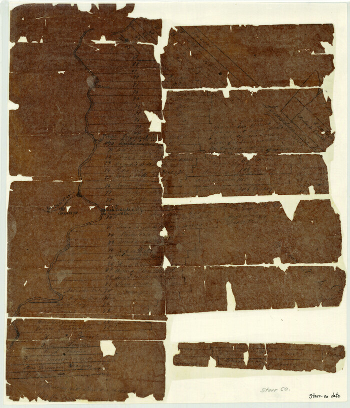
Starr County Sketch File 6

Print $20.00
- Digital $50.00
Starr County Sketch File 6
Size: 43.4 x 36.7 inches
10605
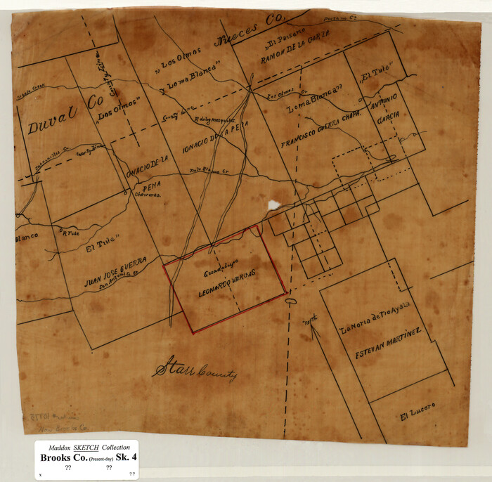
[Sketch of Surveys in Brooks County, Texas]
Print $20.00
- Digital $50.00
[Sketch of Surveys in Brooks County, Texas]
Size: 12.1 x 12.4 inches
10775
Hidalgo County Sketch File 14

Print $20.00
- Digital $50.00
Hidalgo County Sketch File 14
Size: 29.6 x 24.5 inches
11764
Starr County Sketch File 7

Print $20.00
- Digital $50.00
Starr County Sketch File 7
Size: 25.4 x 20.8 inches
12326
Starr County Sketch File 1

Print $4.00
- Digital $50.00
Starr County Sketch File 1
Size: 10.3 x 5.1 inches
36854
Starr County Sketch File 4

Print $3.00
- Digital $50.00
Starr County Sketch File 4
Size: 9.3 x 11.5 inches
36857
Starr County Sketch File 8

Print $7.00
- Digital $50.00
Starr County Sketch File 8
Size: 10.1 x 12.4 inches
36858
Starr County Sketch File 9

Print $22.00
- Digital $50.00
Starr County Sketch File 9
Size: 9.1 x 7.9 inches
36861
Starr County Sketch File 10

Print $40.00
- Digital $50.00
Starr County Sketch File 10
Size: 12.6 x 15.0 inches
36863
Starr County Sketch File 15

Print $10.00
- Digital $50.00
Starr County Sketch File 15
Size: 12.1 x 7.4 inches
36869
Starr County Sketch File 52

Print $4.00
- Digital $50.00
Starr County Sketch File 52
Size: 13.9 x 9.0 inches
37011
[Map of Starr County]
Print $20.00
- Digital $50.00
[Map of Starr County]
Size: 18.8 x 16.2 inches
4049
Starr County Sketch File 14

Print $40.00
- Digital $50.00
Starr County Sketch File 14
Size: 23.8 x 46.0 inches
4626
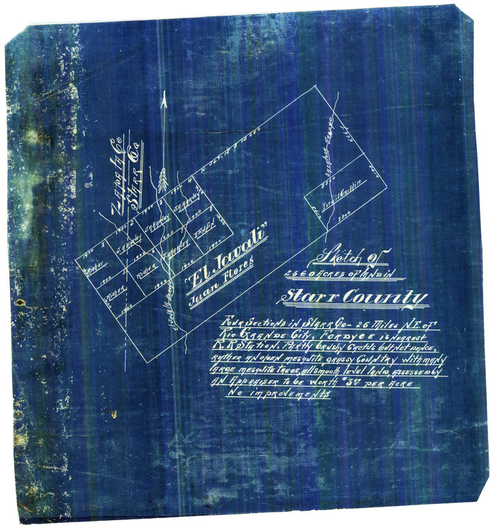
[El Javali Grant,] Sketch of 2560 acres of land in Starr County
Print $20.00
- Digital $50.00
[El Javali Grant,] Sketch of 2560 acres of land in Starr County
Size: 13.4 x 14.0 inches
474
Starr County Rolled Sketch 37

Print $413.00
- Digital $50.00
Starr County Rolled Sketch 37
Size: 10.1 x 15.1 inches
48951
Starr County Boundary File 1

Print $24.00
- Digital $50.00
Starr County Boundary File 1
Size: 13.0 x 8.5 inches
58801
Starr County Boundary File 1a

Print $20.00
- Digital $50.00
Starr County Boundary File 1a
Size: 22.4 x 41.0 inches
58813
Starr County Boundary File 2

Print $8.00
- Digital $50.00
Starr County Boundary File 2
Size: 11.0 x 7.4 inches
58814
Starr County Boundary File 44

Print $98.00
- Digital $50.00
Starr County Boundary File 44
Size: 8.8 x 12.8 inches
58818
Starr County Boundary File 44a

Print $57.00
- Digital $50.00
Starr County Boundary File 44a
Size: 9.3 x 9.4 inches
58827
Starr County Boundary File 99

Print $56.00
- Digital $50.00
Starr County Boundary File 99
Size: 9.2 x 6.2 inches
58846
Starr County Working Sketch 1

Print $40.00
- Digital $50.00
Starr County Working Sketch 1
Size: 26.7 x 65.5 inches
63917
Starr County Working Sketch 6

Print $20.00
- Digital $50.00
Starr County Working Sketch 6
Size: 24.3 x 16.2 inches
63922
No. 1. Outline Map of the Rio Grande from its mouth up to Ringold Barracks

Print $20.00
- Digital $50.00
No. 1. Outline Map of the Rio Grande from its mouth up to Ringold Barracks
Size: 24.8 x 18.3 inches
72857
No. 1. Outline Map of the Rio Grande from its mouth up to Ringold Barracks

Print $20.00
- Digital $50.00
No. 1. Outline Map of the Rio Grande from its mouth up to Ringold Barracks
Size: 24.5 x 18.3 inches
72858
Map showing lands of D. Sullivan situated in Starr County, Texas

Print $20.00
- Digital $50.00
Map showing lands of D. Sullivan situated in Starr County, Texas
Size: 15.5 x 18.6 inches
755
Starr County Rolled Sketch X

Print $121.00
- Digital $50.00
Starr County Rolled Sketch X
Size: 13.3 x 8.1 inches
75961
Starr County Rolled Sketch 8

Print $20.00
- Digital $50.00
Starr County Rolled Sketch 8
Size: 21.5 x 29.6 inches
7796
Starr County Sketch File 5

Print $40.00
- Digital $50.00
Starr County Sketch File 5
Size: 31.4 x 40.7 inches
82571
Zapata County Rolled Sketch 28
Print $20.00
- Digital $50.00
Zapata County Rolled Sketch 28
-
Size
35.5 x 35.3 inches
-
Map/Doc
10174
Starr County Sketch File 6
Print $20.00
- Digital $50.00
Starr County Sketch File 6
-
Size
43.4 x 36.7 inches
-
Map/Doc
10605
[Sketch of Surveys in Brooks County, Texas]
Print $20.00
- Digital $50.00
[Sketch of Surveys in Brooks County, Texas]
-
Size
12.1 x 12.4 inches
-
Map/Doc
10775
Hidalgo County Sketch File 14
Print $20.00
- Digital $50.00
Hidalgo County Sketch File 14
-
Size
29.6 x 24.5 inches
-
Map/Doc
11764
Starr County Sketch File 7
Print $20.00
- Digital $50.00
Starr County Sketch File 7
-
Size
25.4 x 20.8 inches
-
Map/Doc
12326
Starr County Sketch File 1
Print $4.00
- Digital $50.00
Starr County Sketch File 1
-
Size
10.3 x 5.1 inches
-
Map/Doc
36854
Starr County Sketch File 4
Print $3.00
- Digital $50.00
Starr County Sketch File 4
-
Size
9.3 x 11.5 inches
-
Map/Doc
36857
Starr County Sketch File 8
Print $7.00
- Digital $50.00
Starr County Sketch File 8
-
Size
10.1 x 12.4 inches
-
Map/Doc
36858
Starr County Sketch File 9
Print $22.00
- Digital $50.00
Starr County Sketch File 9
-
Size
9.1 x 7.9 inches
-
Map/Doc
36861
Starr County Sketch File 10
Print $40.00
- Digital $50.00
Starr County Sketch File 10
-
Size
12.6 x 15.0 inches
-
Map/Doc
36863
Starr County Sketch File 15
Print $10.00
- Digital $50.00
Starr County Sketch File 15
-
Size
12.1 x 7.4 inches
-
Map/Doc
36869
Starr County Sketch File 52
Print $4.00
- Digital $50.00
Starr County Sketch File 52
-
Size
13.9 x 9.0 inches
-
Map/Doc
37011
[Map of Starr County]
Print $20.00
- Digital $50.00
[Map of Starr County]
-
Size
18.8 x 16.2 inches
-
Map/Doc
4049
Starr County Sketch File 14
Print $40.00
- Digital $50.00
Starr County Sketch File 14
-
Size
23.8 x 46.0 inches
-
Map/Doc
4626
[El Javali Grant,] Sketch of 2560 acres of land in Starr County
Print $20.00
- Digital $50.00
[El Javali Grant,] Sketch of 2560 acres of land in Starr County
-
Size
13.4 x 14.0 inches
-
Map/Doc
474
Starr County Rolled Sketch 37
Print $413.00
- Digital $50.00
Starr County Rolled Sketch 37
-
Size
10.1 x 15.1 inches
-
Map/Doc
48951
Starr County Boundary File 1
Print $24.00
- Digital $50.00
Starr County Boundary File 1
-
Size
13.0 x 8.5 inches
-
Map/Doc
58801
Starr County Boundary File 1a
Print $20.00
- Digital $50.00
Starr County Boundary File 1a
-
Size
22.4 x 41.0 inches
-
Map/Doc
58813
Starr County Boundary File 2
Print $8.00
- Digital $50.00
Starr County Boundary File 2
-
Size
11.0 x 7.4 inches
-
Map/Doc
58814
Starr County Boundary File 44
Print $98.00
- Digital $50.00
Starr County Boundary File 44
-
Size
8.8 x 12.8 inches
-
Map/Doc
58818
Starr County Boundary File 44a
Print $57.00
- Digital $50.00
Starr County Boundary File 44a
-
Size
9.3 x 9.4 inches
-
Map/Doc
58827
Starr County Boundary File 99
Print $56.00
- Digital $50.00
Starr County Boundary File 99
-
Size
9.2 x 6.2 inches
-
Map/Doc
58846
Starr County Working Sketch 1
Print $40.00
- Digital $50.00
Starr County Working Sketch 1
-
Size
26.7 x 65.5 inches
-
Map/Doc
63917
Starr County Working Sketch 6
Print $20.00
- Digital $50.00
Starr County Working Sketch 6
-
Size
24.3 x 16.2 inches
-
Map/Doc
63922
No. 1. Outline Map of the Rio Grande from its mouth up to Ringold Barracks
Print $20.00
- Digital $50.00
No. 1. Outline Map of the Rio Grande from its mouth up to Ringold Barracks
-
Size
24.8 x 18.3 inches
-
Map/Doc
72857
No. 1. Outline Map of the Rio Grande from its mouth up to Ringold Barracks
Print $20.00
- Digital $50.00
No. 1. Outline Map of the Rio Grande from its mouth up to Ringold Barracks
-
Size
24.5 x 18.3 inches
-
Map/Doc
72858
Map showing lands of D. Sullivan situated in Starr County, Texas
Print $20.00
- Digital $50.00
Map showing lands of D. Sullivan situated in Starr County, Texas
-
Size
15.5 x 18.6 inches
-
Map/Doc
755
Starr County Rolled Sketch X
Print $121.00
- Digital $50.00
Starr County Rolled Sketch X
-
Size
13.3 x 8.1 inches
-
Map/Doc
75961
Starr County Rolled Sketch 8
Print $20.00
- Digital $50.00
Starr County Rolled Sketch 8
-
Size
21.5 x 29.6 inches
-
Map/Doc
7796
Starr County Sketch File 5
Print $40.00
- Digital $50.00
Starr County Sketch File 5
-
Size
31.4 x 40.7 inches
-
Map/Doc
82571