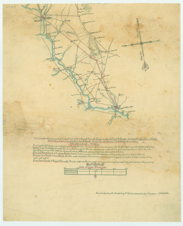
Best Route for Movements of Troops from Laredo to Ringold [sic] Barracks, Texas
Print $20.00
Best Route for Movements of Troops from Laredo to Ringold [sic] Barracks, Texas
1865
Size: 18.9 x 15.3 inches
79299
Brooks County Working Sketch 6

Print $20.00
- Digital $50.00
Brooks County Working Sketch 6
1917
Size: 28.6 x 15.7 inches
67790
Brooks County Working Sketch 8

Print $20.00
- Digital $50.00
Brooks County Working Sketch 8
1928
Size: 27.6 x 23.3 inches
67792
Duval County Rolled Sketch 30A

Print $40.00
- Digital $50.00
Duval County Rolled Sketch 30A
1896
Size: 59.7 x 40.8 inches
76145
General Highway Map, Starr County, Texas

Print $20.00
General Highway Map, Starr County, Texas
1940
Size: 24.7 x 18.5 inches
79245
General Highway Map, Starr County, Texas

Print $20.00
General Highway Map, Starr County, Texas
1940
Size: 24.8 x 18.5 inches
79246
General Highway Map, Starr County, Texas

Print $20.00
General Highway Map, Starr County, Texas
1961
Size: 24.9 x 18.1 inches
79658
General Highway Map, Starr County, Texas

Print $20.00
General Highway Map, Starr County, Texas
1961
Size: 25.1 x 18.3 inches
79659
Hidalgo County Sketch

Print $20.00
- Digital $50.00
Hidalgo County Sketch
1903
Size: 30.4 x 37.7 inches
4450
Hidalgo County Sketch File 10

Print $20.00
- Digital $50.00
Hidalgo County Sketch File 10
1911
Size: 16.3 x 34.8 inches
11762
Hidalgo County Sketch File 14

Print $20.00
- Digital $50.00
Hidalgo County Sketch File 14
Size: 29.6 x 24.5 inches
11764
Hidalgo County Sketch File 6

Print $4.00
- Digital $50.00
Hidalgo County Sketch File 6
1891
Size: 10.3 x 8.4 inches
26403
Hidalgo County Sketch File 9

Print $40.00
- Digital $50.00
Hidalgo County Sketch File 9
1904
Size: 8.8 x 5.7 inches
26409
Hidalgo County Working Sketch 5

Print $20.00
- Digital $50.00
Hidalgo County Working Sketch 5
1956
Size: 38.1 x 37.9 inches
66182
Jim Hogg County Rolled Sketch 3

Print $20.00
- Digital $50.00
Jim Hogg County Rolled Sketch 3
1912
Size: 28.2 x 20.2 inches
6439
Jim Hogg County Rolled Sketch 7

Print $20.00
- Digital $50.00
Jim Hogg County Rolled Sketch 7
1948
Size: 32.5 x 28.2 inches
6442
Jim Hogg County Rolled Sketch EJ

Print $40.00
- Digital $50.00
Jim Hogg County Rolled Sketch EJ
1933
Size: 50.7 x 37.0 inches
9321
Jim Hogg County Rolled Sketch EJF

Print $20.00
- Digital $50.00
Jim Hogg County Rolled Sketch EJF
1937
Size: 36.0 x 32.4 inches
9320
Jim Hogg County Sketch File 1

Print $20.00
- Digital $50.00
Jim Hogg County Sketch File 1
1931
Size: 18.2 x 26.7 inches
11883
Land grants from the state of Tamaulipas in the trans-Nueces

Land grants from the state of Tamaulipas in the trans-Nueces
2009
Size: 11.0 x 8.5 inches
94040
Map and General Information of Lower Rio Grande Valley of Texas

Print $20.00
Map and General Information of Lower Rio Grande Valley of Texas
1937
Size: 21.4 x 33.9 inches
76313
Map of Cameron, Hidalgo and half of Starr County of Texas

Print $20.00
- Digital $50.00
Map of Cameron, Hidalgo and half of Starr County of Texas
1900
Size: 42.4 x 30.3 inches
3150
Map of San Patricio District

Print $40.00
- Digital $50.00
Map of San Patricio District
1870
Size: 43.8 x 51.4 inches
1987
Map of Starr County

Print $20.00
- Digital $50.00
Map of Starr County
1880
Size: 46.8 x 27.0 inches
4044
Map of Starr County

Print $40.00
- Digital $50.00
Map of Starr County
1900
Size: 51.6 x 25.8 inches
4046
Map of Starr County

Print $20.00
- Digital $50.00
Map of Starr County
1896
Size: 43.7 x 26.9 inches
4050
Map of Starr County State of Texas

Print $20.00
- Digital $50.00
Map of Starr County State of Texas
1911
Size: 25.1 x 23.2 inches
4048
Map of Starr County Texas

Print $20.00
- Digital $50.00
Map of Starr County Texas
1935
Size: 20.2 x 26.8 inches
4047
Map of the Rio Grande Frontier, Texas, East of Fort McIntosh and South of the Mex. National RR.

Print $20.00
- Digital $50.00
Map of the Rio Grande Frontier, Texas, East of Fort McIntosh and South of the Mex. National RR.
1892
Size: 26.1 x 39.8 inches
4660
Map showing lands of D. Sullivan known as Santa Rosa Ranch situated in Cameron and Hidalgo Counties, Texas

Print $20.00
- Digital $50.00
Map showing lands of D. Sullivan known as Santa Rosa Ranch situated in Cameron and Hidalgo Counties, Texas
1905
Size: 26.2 x 23.2 inches
4455
Best Route for Movements of Troops from Laredo to Ringold [sic] Barracks, Texas
Print $20.00
Best Route for Movements of Troops from Laredo to Ringold [sic] Barracks, Texas
1865
-
Size
18.9 x 15.3 inches
-
Map/Doc
79299
-
Creation Date
1865
Brooks County Working Sketch 6
Print $20.00
- Digital $50.00
Brooks County Working Sketch 6
1917
-
Size
28.6 x 15.7 inches
-
Map/Doc
67790
-
Creation Date
1917
Brooks County Working Sketch 8
Print $20.00
- Digital $50.00
Brooks County Working Sketch 8
1928
-
Size
27.6 x 23.3 inches
-
Map/Doc
67792
-
Creation Date
1928
Duval County Rolled Sketch 30A
Print $40.00
- Digital $50.00
Duval County Rolled Sketch 30A
1896
-
Size
59.7 x 40.8 inches
-
Map/Doc
76145
-
Creation Date
1896
General Highway Map, Starr County, Texas
Print $20.00
General Highway Map, Starr County, Texas
1940
-
Size
24.7 x 18.5 inches
-
Map/Doc
79245
-
Creation Date
1940
General Highway Map, Starr County, Texas
Print $20.00
General Highway Map, Starr County, Texas
1940
-
Size
24.8 x 18.5 inches
-
Map/Doc
79246
-
Creation Date
1940
General Highway Map, Starr County, Texas
Print $20.00
General Highway Map, Starr County, Texas
1961
-
Size
24.9 x 18.1 inches
-
Map/Doc
79658
-
Creation Date
1961
General Highway Map, Starr County, Texas
Print $20.00
General Highway Map, Starr County, Texas
1961
-
Size
25.1 x 18.3 inches
-
Map/Doc
79659
-
Creation Date
1961
Hidalgo County Sketch
Print $20.00
- Digital $50.00
Hidalgo County Sketch
1903
-
Size
30.4 x 37.7 inches
-
Map/Doc
4450
-
Creation Date
1903
Hidalgo County Sketch File 10
Print $20.00
- Digital $50.00
Hidalgo County Sketch File 10
1911
-
Size
16.3 x 34.8 inches
-
Map/Doc
11762
-
Creation Date
1911
Hidalgo County Sketch File 14
Print $20.00
- Digital $50.00
Hidalgo County Sketch File 14
-
Size
29.6 x 24.5 inches
-
Map/Doc
11764
Hidalgo County Sketch File 6
Print $4.00
- Digital $50.00
Hidalgo County Sketch File 6
1891
-
Size
10.3 x 8.4 inches
-
Map/Doc
26403
-
Creation Date
1891
Hidalgo County Sketch File 9
Print $40.00
- Digital $50.00
Hidalgo County Sketch File 9
1904
-
Size
8.8 x 5.7 inches
-
Map/Doc
26409
-
Creation Date
1904
Hidalgo County Working Sketch 5
Print $20.00
- Digital $50.00
Hidalgo County Working Sketch 5
1956
-
Size
38.1 x 37.9 inches
-
Map/Doc
66182
-
Creation Date
1956
Jim Hogg County Rolled Sketch 3
Print $20.00
- Digital $50.00
Jim Hogg County Rolled Sketch 3
1912
-
Size
28.2 x 20.2 inches
-
Map/Doc
6439
-
Creation Date
1912
Jim Hogg County Rolled Sketch 7
Print $20.00
- Digital $50.00
Jim Hogg County Rolled Sketch 7
1948
-
Size
32.5 x 28.2 inches
-
Map/Doc
6442
-
Creation Date
1948
Jim Hogg County Rolled Sketch EJ
Print $40.00
- Digital $50.00
Jim Hogg County Rolled Sketch EJ
1933
-
Size
50.7 x 37.0 inches
-
Map/Doc
9321
-
Creation Date
1933
Jim Hogg County Rolled Sketch EJF
Print $20.00
- Digital $50.00
Jim Hogg County Rolled Sketch EJF
1937
-
Size
36.0 x 32.4 inches
-
Map/Doc
9320
-
Creation Date
1937
Jim Hogg County Sketch File 1
Print $20.00
- Digital $50.00
Jim Hogg County Sketch File 1
1931
-
Size
18.2 x 26.7 inches
-
Map/Doc
11883
-
Creation Date
1931
Land grants from the state of Tamaulipas in the trans-Nueces
Land grants from the state of Tamaulipas in the trans-Nueces
2009
-
Size
11.0 x 8.5 inches
-
Map/Doc
94040
-
Creation Date
2009
Map and General Information of Lower Rio Grande Valley of Texas
Print $20.00
Map and General Information of Lower Rio Grande Valley of Texas
1937
-
Size
21.4 x 33.9 inches
-
Map/Doc
76313
-
Creation Date
1937
Map of Cameron, Hidalgo and half of Starr County of Texas
Print $20.00
- Digital $50.00
Map of Cameron, Hidalgo and half of Starr County of Texas
1900
-
Size
42.4 x 30.3 inches
-
Map/Doc
3150
-
Creation Date
1900
Map of San Patricio District
Print $40.00
- Digital $50.00
Map of San Patricio District
1870
-
Size
43.8 x 51.4 inches
-
Map/Doc
1987
-
Creation Date
1870
Map of Starr County
Print $20.00
- Digital $50.00
Map of Starr County
1880
-
Size
46.8 x 27.0 inches
-
Map/Doc
4044
-
Creation Date
1880
Map of Starr County
Print $40.00
- Digital $50.00
Map of Starr County
1900
-
Size
51.6 x 25.8 inches
-
Map/Doc
4046
-
Creation Date
1900
Map of Starr County
Print $20.00
- Digital $50.00
Map of Starr County
1896
-
Size
43.7 x 26.9 inches
-
Map/Doc
4050
-
Creation Date
1896
Map of Starr County State of Texas
Print $20.00
- Digital $50.00
Map of Starr County State of Texas
1911
-
Size
25.1 x 23.2 inches
-
Map/Doc
4048
-
Creation Date
1911
Map of Starr County Texas
Print $20.00
- Digital $50.00
Map of Starr County Texas
1935
-
Size
20.2 x 26.8 inches
-
Map/Doc
4047
-
Creation Date
1935
Map of the Rio Grande Frontier, Texas, East of Fort McIntosh and South of the Mex. National RR.
Print $20.00
- Digital $50.00
Map of the Rio Grande Frontier, Texas, East of Fort McIntosh and South of the Mex. National RR.
1892
-
Size
26.1 x 39.8 inches
-
Map/Doc
4660
-
Creation Date
1892
Map showing lands of D. Sullivan known as Santa Rosa Ranch situated in Cameron and Hidalgo Counties, Texas
Print $20.00
- Digital $50.00
Map showing lands of D. Sullivan known as Santa Rosa Ranch situated in Cameron and Hidalgo Counties, Texas
1905
-
Size
26.2 x 23.2 inches
-
Map/Doc
4455
-
Creation Date
1905