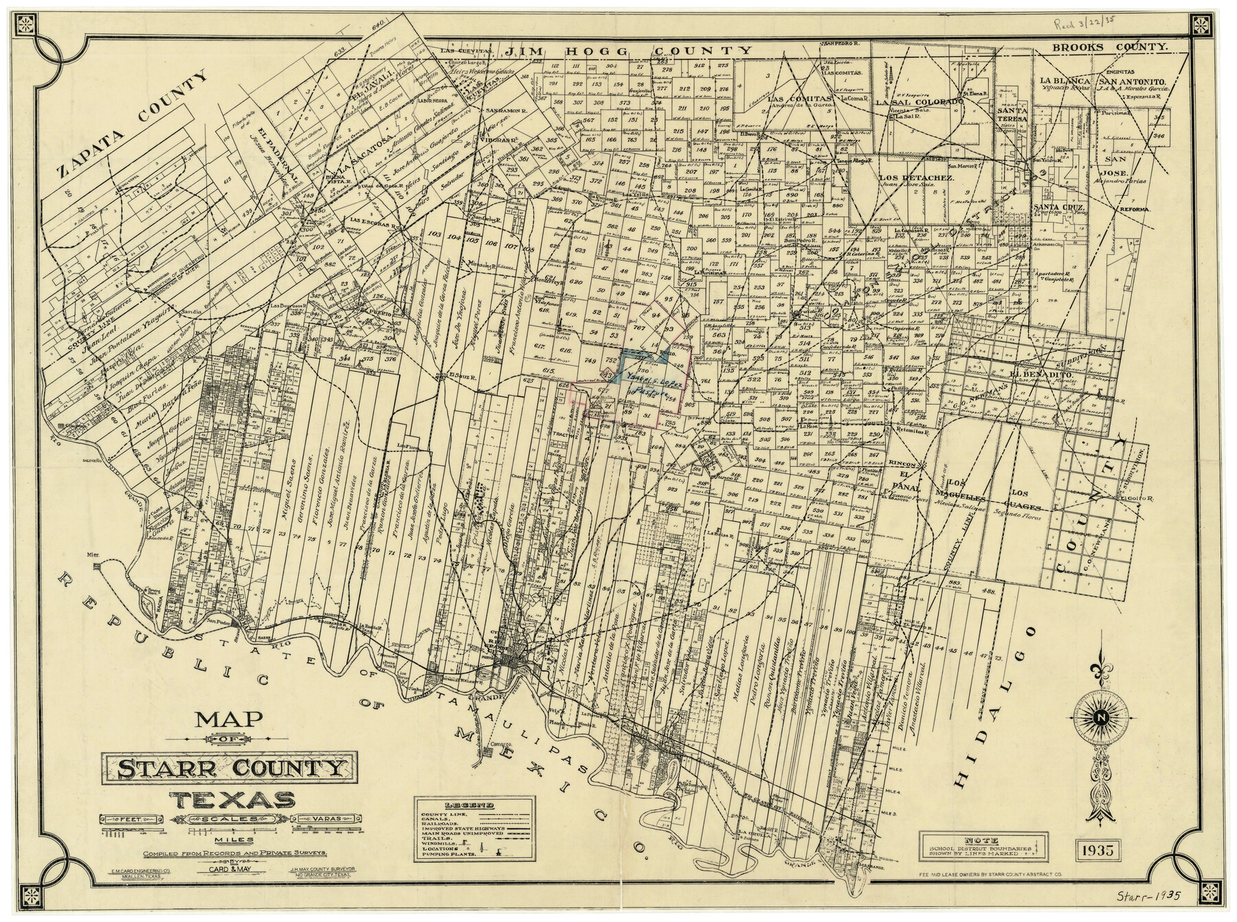
Map of Starr County Texas
-
Map/Doc
4047
-
Collection
General Map Collection
-
Object Dates
1935 (Creation Date)
-
People and Organizations
Starr County Abstract Company (Publisher)
J.H. May (Compiler)
E.M. Card (Compiler)
J.H. May (Surveyor/Engineer)
-
Counties
Starr
-
Subjects
County
-
Height x Width
20.2 x 26.8 inches
51.3 x 68.1 cm
-
Comments
Received in office March 22, 1935.
-
Features
Charco Palomas
Roma
Saens
State Highway No. 4
Morenos
Escobares
Garzena
Starr
Barreras
Remolino
Rio Grande City
El Pinto
Hacha
La Brisa
Casas Blancas
Saucedo
Loma Blanca
La Gloria
Charco Blanco
El Ebanito
Rincon
El Golro
Matarza
Lake Pinto Ballo
Santo Domingo
Los Ebanos
Antecitos
San Jose
Solises
La Grulla
Ratcliff
Camargo
San Juan River
RGRR
Dracme Lake
Military Road
Ritamitas
Casitas
La Puerta
Vela
Placitos
Olmos
Los Villareales
Kelsey
Garcia
Los Perez
Los Garzas
Mier
Viboras
Arkansas City
La Purisima
San Carlos
Mirasoles
Las Escobas
Montenegro
Palmira
Misteros
Buena Vista
Unas del Gato
Huisache
Santa Cruz
Tia Romano
La Comita
El Bravo
Rucio
San Marcos
San Ysidro
Encinitas
La Coma
La Sal
St. Elena
San Pedro
Canales
Pallilo
Retamosa
La Mesa
Brazil Lake
Las Flores
El Sauz
Munoz
Reforma
Salineño
Rio Grande
Chapeno
Las Cuevitas
Sandia
Bollo
Las Burrosos
El Puerto
Los Olmos Creek
Paradido
Confederado
Coyote
Capirota
Guajalote
Apartadero
Part of: General Map Collection
Navasota River, Long Bridge Crossing Sheet

Print $20.00
- Digital $50.00
Navasota River, Long Bridge Crossing Sheet
1934
Size 43.1 x 36.6 inches
Map/Doc 65073
Travis County Working Sketch 35

Print $20.00
- Digital $50.00
Travis County Working Sketch 35
1966
Size 30.4 x 35.5 inches
Map/Doc 69419
Flight Mission No. CRE-1R, Frame 122, Jackson County

Print $20.00
- Digital $50.00
Flight Mission No. CRE-1R, Frame 122, Jackson County
1956
Size 16.2 x 16.0 inches
Map/Doc 85333
Wichita County Working Sketch 22

Print $20.00
- Digital $50.00
Wichita County Working Sketch 22
1952
Size 22.2 x 27.1 inches
Map/Doc 72532
Erath County Sketch File 10a

Print $4.00
- Digital $50.00
Erath County Sketch File 10a
1871
Size 8.0 x 12.8 inches
Map/Doc 22277
Lamar County State Real Property Sketch 1

Print $20.00
- Digital $50.00
Lamar County State Real Property Sketch 1
2013
Size 24.0 x 36.0 inches
Map/Doc 93660
Hopkins County Sketch File 13

Print $4.00
- Digital $50.00
Hopkins County Sketch File 13
1858
Size 12.7 x 8.2 inches
Map/Doc 26709
Kleberg County Aerial Photograph Index Sheet 2

Print $20.00
- Digital $50.00
Kleberg County Aerial Photograph Index Sheet 2
1956
Size 19.4 x 23.4 inches
Map/Doc 83719
Coryell County

Print $20.00
- Digital $50.00
Coryell County
1936
Size 44.5 x 41.2 inches
Map/Doc 73117
Grimes County Working Sketch 6

Print $20.00
- Digital $50.00
Grimes County Working Sketch 6
1951
Size 33.2 x 33.4 inches
Map/Doc 63297
Concho County Sketch File 36

Print $20.00
- Digital $50.00
Concho County Sketch File 36
1938
Size 17.9 x 18.6 inches
Map/Doc 11161
South Sulphur River, Charleston Sheet

Print $20.00
- Digital $50.00
South Sulphur River, Charleston Sheet
1924
Size 16.6 x 18.0 inches
Map/Doc 78326
You may also like
Dickens County Sketch File 28

Print $23.00
- Digital $50.00
Dickens County Sketch File 28
Size 14.5 x 9.0 inches
Map/Doc 21005
Tom Green County Sketch File 55 1/2

Print $20.00
- Digital $50.00
Tom Green County Sketch File 55 1/2
1886
Size 26.4 x 13.6 inches
Map/Doc 12443
Collin County Sketch File 4

Print $4.00
- Digital $50.00
Collin County Sketch File 4
1856
Size 10.0 x 8.0 inches
Map/Doc 18862
Map of Liberty County Texas

Print $20.00
- Digital $50.00
Map of Liberty County Texas
1895
Size 25.1 x 26.6 inches
Map/Doc 3812
Gray County Sketch File 14

Print $4.00
- Digital $50.00
Gray County Sketch File 14
1946
Size 11.3 x 8.9 inches
Map/Doc 24457
Castro County Working Sketch 1

Print $20.00
- Digital $50.00
Castro County Working Sketch 1
Size 22.8 x 17.7 inches
Map/Doc 67896
McCulloch County Rolled Sketch 1

Print $20.00
- Digital $50.00
McCulloch County Rolled Sketch 1
Size 44.4 x 36.9 inches
Map/Doc 9495
Cherokee County Working Sketch 3

Print $20.00
- Digital $50.00
Cherokee County Working Sketch 3
1934
Size 29.6 x 42.7 inches
Map/Doc 67958
Flight Mission No. CUG-3P, Frame 133, Kleberg County

Print $20.00
- Digital $50.00
Flight Mission No. CUG-3P, Frame 133, Kleberg County
1956
Size 18.7 x 22.2 inches
Map/Doc 86268
Polk County Rolled Sketch TMS

Print $40.00
- Digital $50.00
Polk County Rolled Sketch TMS
1937
Size 35.7 x 56.5 inches
Map/Doc 9756
Orange County Working Sketch 42

Print $20.00
- Digital $50.00
Orange County Working Sketch 42
1979
Size 19.6 x 25.4 inches
Map/Doc 71374
Office sketch of surveys on St. Joseph Island and Mustang Island in Aransas & Nueces Cos.

Print $20.00
- Digital $50.00
Office sketch of surveys on St. Joseph Island and Mustang Island in Aransas & Nueces Cos.
1978
Size 42.8 x 17.7 inches
Map/Doc 2252