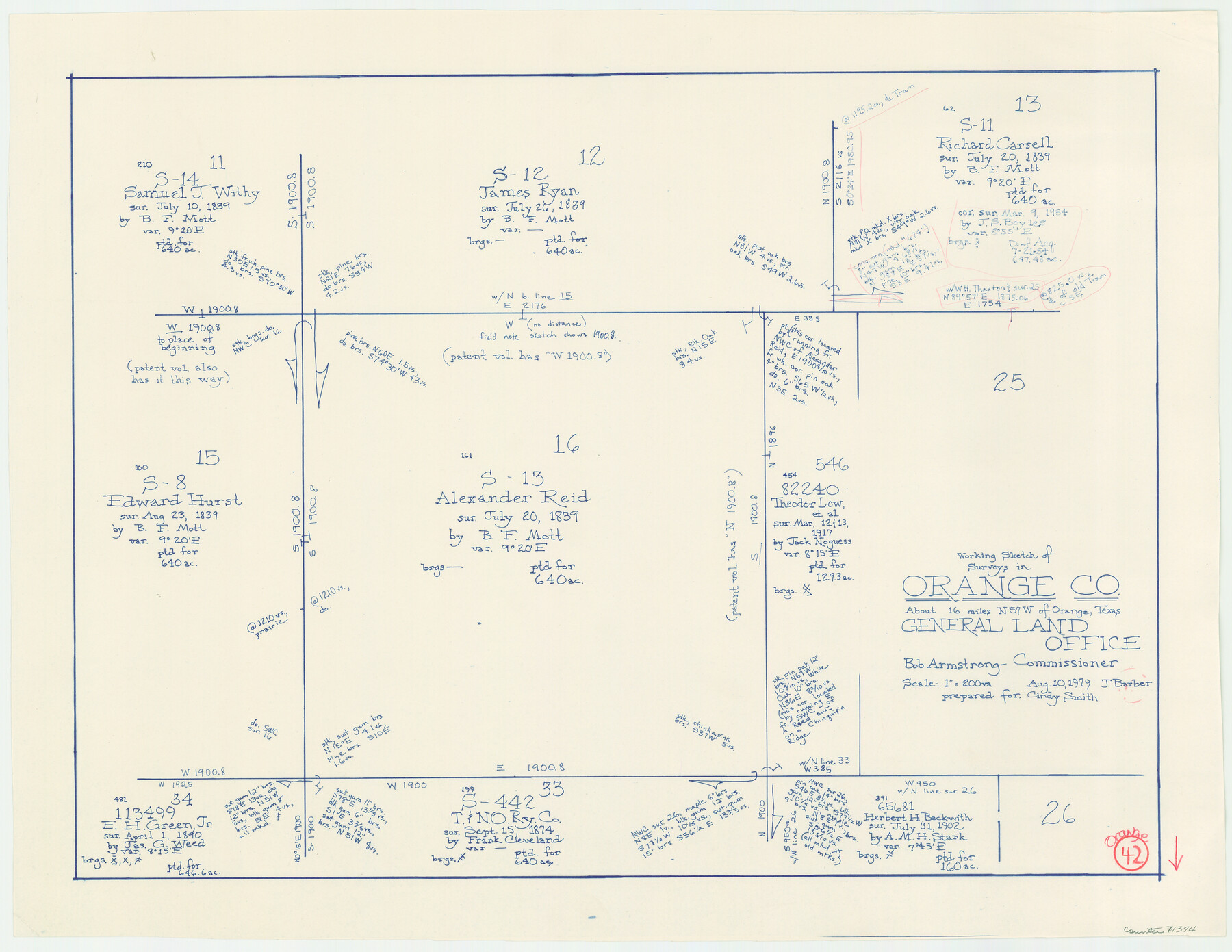
Orange County Working Sketch 42
-
Map/Doc
71374
-
Collection
General Map Collection
-
Object Dates
8/10/1979 (Creation Date)
-
Counties
Orange
-
Subjects
Surveying Working Sketch
-
Height x Width
19.6 x 25.4 inches
49.8 x 64.5 cm
-
Scale
1" = 200 varas
Part of: General Map Collection
Atascosa County Rolled Sketch 13

Print $20.00
- Digital $50.00
Atascosa County Rolled Sketch 13
1944
Size 34.8 x 27.7 inches
Map/Doc 5095
Galveston Bay and Approaches

Print $20.00
- Digital $50.00
Galveston Bay and Approaches
1961
Size 46.2 x 34.1 inches
Map/Doc 69878
Hale County Sketch File 16

Print $4.00
- Digital $50.00
Hale County Sketch File 16
1888
Size 12.8 x 8.2 inches
Map/Doc 24747
Flight Mission No. DQO-1K, Frame 94, Galveston County

Print $20.00
- Digital $50.00
Flight Mission No. DQO-1K, Frame 94, Galveston County
1952
Size 18.9 x 22.6 inches
Map/Doc 84990
Matagorda County Aerial Photograph Index Sheet 7

Print $20.00
- Digital $50.00
Matagorda County Aerial Photograph Index Sheet 7
1953
Size 23.7 x 19.7 inches
Map/Doc 83728
Clarkson's City Map of Port Aransas

Print $20.00
- Digital $50.00
Clarkson's City Map of Port Aransas
Size 18.5 x 26.5 inches
Map/Doc 3040
Pecos County Rolled Sketch DK1

Print $20.00
- Digital $50.00
Pecos County Rolled Sketch DK1
1938
Size 36.2 x 43.7 inches
Map/Doc 9713
Hardin County Sketch File 31

Print $2.00
- Digital $50.00
Hardin County Sketch File 31
Size 8.5 x 7.1 inches
Map/Doc 25162
Flight Mission No. DAH-17M, Frame 26, Orange County

Print $20.00
- Digital $50.00
Flight Mission No. DAH-17M, Frame 26, Orange County
1953
Size 18.3 x 22.3 inches
Map/Doc 86889
Coleman County Sketch File 10

Print $20.00
- Digital $50.00
Coleman County Sketch File 10
1848
Size 28.0 x 13.2 inches
Map/Doc 11119
Rusk County Working Sketch 36

Print $20.00
- Digital $50.00
Rusk County Working Sketch 36
2007
Size 31.7 x 36.0 inches
Map/Doc 83786
Controlled Mosaic by Jack Amman Photogrammetric Engineers, Inc - Sheet 5

Print $20.00
- Digital $50.00
Controlled Mosaic by Jack Amman Photogrammetric Engineers, Inc - Sheet 5
1954
Size 20.8 x 24.0 inches
Map/Doc 83449
You may also like
Baylor County Sketch File Z4

Print $2.00
- Digital $50.00
Baylor County Sketch File Z4
1898
Size 9.3 x 7.2 inches
Map/Doc 14114
Flight Mission No. BRA-6M, Frame 94, Jefferson County

Print $20.00
- Digital $50.00
Flight Mission No. BRA-6M, Frame 94, Jefferson County
1953
Size 18.6 x 22.4 inches
Map/Doc 85437
Pecos County Rolled Sketch 59

Print $20.00
- Digital $50.00
Pecos County Rolled Sketch 59
1922
Size 16.6 x 17.0 inches
Map/Doc 7231
Duval County Sketch File 31

Print $20.00
- Digital $50.00
Duval County Sketch File 31
1932
Size 29.3 x 17.7 inches
Map/Doc 11389
Red River County Rolled Sketch 9

Print $20.00
- Digital $50.00
Red River County Rolled Sketch 9
Size 27.1 x 18.1 inches
Map/Doc 7475
General Highway Map, Roberts County, Texas

Print $20.00
General Highway Map, Roberts County, Texas
1940
Size 18.4 x 25.0 inches
Map/Doc 79229
Dawson County Rolled Sketch 10

Print $20.00
- Digital $50.00
Dawson County Rolled Sketch 10
1954
Size 44.5 x 37.9 inches
Map/Doc 8774
Real County Working Sketch 17

Print $20.00
- Digital $50.00
Real County Working Sketch 17
1941
Size 18.8 x 24.3 inches
Map/Doc 71909

General Highway Map, Jeff Davis County, Texas

Print $20.00
General Highway Map, Jeff Davis County, Texas
1961
Size 18.3 x 24.6 inches
Map/Doc 79536
[H. & T. C. 46, Sections 79- 84]
![91262, [H. & T. C. 46, Sections 79- 84], Twichell Survey Records](https://historictexasmaps.com/wmedia_w700/maps/91262-1.tif.jpg)
Print $20.00
- Digital $50.00
[H. & T. C. 46, Sections 79- 84]
Size 27.3 x 32.6 inches
Map/Doc 91262
Flight Mission No. DAG-23K, Frame 179, Matagorda County

Print $20.00
- Digital $50.00
Flight Mission No. DAG-23K, Frame 179, Matagorda County
1953
Size 18.5 x 22.4 inches
Map/Doc 86514