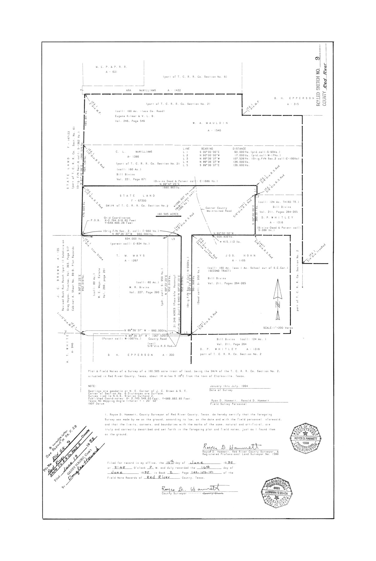
Red River County Rolled Sketch 9
Plat & field notes of a survey of a 160.585 acre tract of land being the SW/4 of the T. C. R.R. Co. section no. 2 situated in Red River County, Texas
-
Map/Doc
7475
-
Collection
General Map Collection
-
Object Dates
1994 (Survey Date)
1995/6/19 (File Date)
-
People and Organizations
Royce D. Hammett (Surveyor/Engineer)
Ryan D. Hammett (Chainman/Field Personnel)
Ronald D. Hammett (Chainman/Field Personnel)
-
Counties
Red River
-
Subjects
Surveying Rolled Sketch
-
Height x Width
27.1 x 18.1 inches
68.8 x 46.0 cm
-
Scale
1" = 200 varas
-
Comments
See Red River County Sketch File 28 (35165) for report.
Related maps
Red River County Sketch File 28

Print $22.00
- Digital $50.00
Red River County Sketch File 28
1995
Size 11.3 x 8.9 inches
Map/Doc 35165
Part of: General Map Collection
Upton County Sketch File 15

Print $20.00
- Digital $50.00
Upton County Sketch File 15
1927
Size 34.3 x 19.5 inches
Map/Doc 12513
Newton County Rolled Sketch 18

Print $40.00
- Digital $50.00
Newton County Rolled Sketch 18
1955
Size 41.6 x 59.2 inches
Map/Doc 9580
Burnet County Sketch File 7

Print $6.00
- Digital $50.00
Burnet County Sketch File 7
1854
Size 7.1 x 8.1 inches
Map/Doc 16686
Refugio County Working Sketch Graphic Index

Print $20.00
- Digital $50.00
Refugio County Working Sketch Graphic Index
1921
Size 38.9 x 47.8 inches
Map/Doc 76683
Cass County Working Sketch 37

Print $20.00
- Digital $50.00
Cass County Working Sketch 37
1982
Size 26.8 x 31.8 inches
Map/Doc 67940
Castro County Sketch File 6

Print $20.00
- Digital $50.00
Castro County Sketch File 6
Size 20.8 x 15.6 inches
Map/Doc 11059
Kerr County Working Sketch 28

Print $20.00
- Digital $50.00
Kerr County Working Sketch 28
1971
Size 38.5 x 39.1 inches
Map/Doc 70059
McLennan County Sketch File 16

Print $4.00
- Digital $50.00
McLennan County Sketch File 16
1873
Size 12.7 x 8.2 inches
Map/Doc 31276
[Surveys in Austin's Colony along the Navasota River and Ten Mile Creek]
![80, [Surveys in Austin's Colony along the Navasota River and Ten Mile Creek], General Map Collection](https://historictexasmaps.com/wmedia_w700/maps/80.tif.jpg)
Print $20.00
- Digital $50.00
[Surveys in Austin's Colony along the Navasota River and Ten Mile Creek]
1821
Size 29.2 x 18.0 inches
Map/Doc 80
Webb County Working Sketch 68

Print $40.00
- Digital $50.00
Webb County Working Sketch 68
1967
Size 31.6 x 50.7 inches
Map/Doc 72435
Bandera County Boundary File 7

Print $14.00
- Digital $50.00
Bandera County Boundary File 7
Size 12.7 x 8.1 inches
Map/Doc 50306
Lamb County Rolled Sketch 9

Print $20.00
- Digital $50.00
Lamb County Rolled Sketch 9
Size 44.7 x 27.9 inches
Map/Doc 9417
You may also like
[Sketch of J.D. Brown survey and vicinity]
![89965, [Sketch of J.D. Brown survey and vicinity], Twichell Survey Records](https://historictexasmaps.com/wmedia_w700/maps/89965-1.tif.jpg)
Print $40.00
- Digital $50.00
[Sketch of J.D. Brown survey and vicinity]
Size 43.5 x 63.0 inches
Map/Doc 89965
Flight Mission No. DIX-6P, Frame 114, Aransas County

Print $20.00
- Digital $50.00
Flight Mission No. DIX-6P, Frame 114, Aransas County
1956
Size 19.1 x 23.0 inches
Map/Doc 83820

Map of the Surveyed Part of Young District

Print $40.00
- Digital $50.00
Map of the Surveyed Part of Young District
1860
Size 56.2 x 54.7 inches
Map/Doc 1986
Controlled Mosaic by Jack Amman Photogrammetric Engineers, Inc - Sheet 17

Print $20.00
- Digital $50.00
Controlled Mosaic by Jack Amman Photogrammetric Engineers, Inc - Sheet 17
1954
Size 20.0 x 24.0 inches
Map/Doc 83461
Menard County Rolled Sketch 10

Print $20.00
- Digital $50.00
Menard County Rolled Sketch 10
1955
Size 46.7 x 37.7 inches
Map/Doc 9511
[J. E. and J. W. Rhea's Ranch situated in Parmer Co., Texas]
![91652, [J. E. and J. W. Rhea's Ranch situated in Parmer Co., Texas], Twichell Survey Records](https://historictexasmaps.com/wmedia_w700/maps/91652-1.tif.jpg)
Print $20.00
- Digital $50.00
[J. E. and J. W. Rhea's Ranch situated in Parmer Co., Texas]
Size 23.2 x 25.8 inches
Map/Doc 91652
Bird's Eye View of the City of Galveston Texas

Print $20.00
Bird's Eye View of the City of Galveston Texas
1871
Size 20.4 x 30.8 inches
Map/Doc 89086
Tyler County Working Sketch 5

Print $20.00
- Digital $50.00
Tyler County Working Sketch 5
1928
Size 19.4 x 21.2 inches
Map/Doc 69475
Floyd County, Texas

Print $20.00
- Digital $50.00
Floyd County, Texas
1889
Size 24.8 x 19.2 inches
Map/Doc 626
Jeff Davis County Working Sketch Graphic Index - central part

Print $40.00
- Digital $50.00
Jeff Davis County Working Sketch Graphic Index - central part
1982
Size 55.7 x 42.6 inches
Map/Doc 76593
La Salle County Working Sketch 10

Print $20.00
- Digital $50.00
La Salle County Working Sketch 10
1928
Size 30.6 x 20.5 inches
Map/Doc 70311