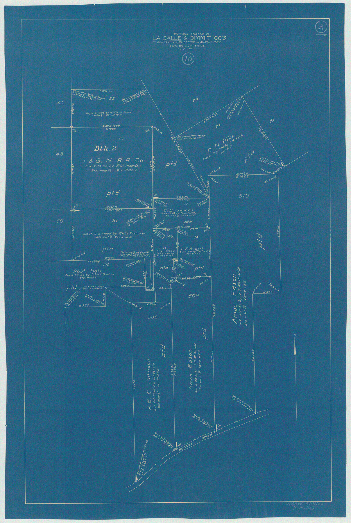
La Salle County Working Sketch 10
-
Map/Doc
70311
-
Collection
General Map Collection
-
Object Dates
5/9/1928 (Creation Date)
-
People and Organizations
J. Bascom Giles (Draftsman)
-
Counties
La Salle Dimmit
-
Subjects
Surveying Working Sketch
-
Height x Width
30.6 x 20.5 inches
77.7 x 52.1 cm
-
Scale
1" = 400 varas
Part of: General Map Collection
Flight Mission No. BRA-16M, Frame 116, Jefferson County

Print $20.00
- Digital $50.00
Flight Mission No. BRA-16M, Frame 116, Jefferson County
1953
Size 18.5 x 22.3 inches
Map/Doc 85726
Bandera County Working Sketch 38

Print $20.00
- Digital $50.00
Bandera County Working Sketch 38
1971
Size 30.4 x 31.5 inches
Map/Doc 67634
San Augustine County Working Sketch 24

Print $20.00
- Digital $50.00
San Augustine County Working Sketch 24
1975
Size 27.8 x 39.1 inches
Map/Doc 63712
Kendall County Sketch File 4

Print $4.00
- Digital $50.00
Kendall County Sketch File 4
Size 7.8 x 8.6 inches
Map/Doc 28684
Terrell County Working Sketch 42

Print $20.00
- Digital $50.00
Terrell County Working Sketch 42
1957
Size 34.4 x 34.4 inches
Map/Doc 62135
Map of Roberts County

Print $40.00
- Digital $50.00
Map of Roberts County
1900
Size 45.3 x 50.0 inches
Map/Doc 3990
Montague County Sketch File 22

Print $20.00
- Digital $50.00
Montague County Sketch File 22
1927
Size 27.7 x 20.1 inches
Map/Doc 12107
Maps of Gulf Intracoastal Waterway, Texas - Sabine River to the Rio Grande and connecting waterways including ship channels

Print $20.00
- Digital $50.00
Maps of Gulf Intracoastal Waterway, Texas - Sabine River to the Rio Grande and connecting waterways including ship channels
1966
Size 14.5 x 22.2 inches
Map/Doc 61926
Lee County Working Sketch 11

Print $20.00
- Digital $50.00
Lee County Working Sketch 11
1980
Size 25.2 x 25.7 inches
Map/Doc 70390
Mississippi River to Galveston

Print $40.00
- Digital $50.00
Mississippi River to Galveston
1966
Size 37.0 x 49.8 inches
Map/Doc 69945
Houston County Sketch File 34

Print $6.00
- Digital $50.00
Houston County Sketch File 34
1914
Size 13.3 x 11.0 inches
Map/Doc 26811
Bandera County Working Sketch 16d

Print $20.00
- Digital $50.00
Bandera County Working Sketch 16d
1941
Size 19.1 x 23.2 inches
Map/Doc 67612
You may also like
San Jacinto County Working Sketch 35

Print $20.00
- Digital $50.00
San Jacinto County Working Sketch 35
1955
Size 31.3 x 32.1 inches
Map/Doc 63748
A plat representing the survey and resubdivision of four tracts of land known as tracts no. 27, no. 26, no. 23, and no. 22, all of which are part of the Tara Subdivision, an unrecorded subdivision of 263.28 acres out of the J. M. Speer Subdivision

Print $6.00
- Digital $50.00
A plat representing the survey and resubdivision of four tracts of land known as tracts no. 27, no. 26, no. 23, and no. 22, all of which are part of the Tara Subdivision, an unrecorded subdivision of 263.28 acres out of the J. M. Speer Subdivision
1991
Size 24.7 x 34.3 inches
Map/Doc 3112
Sketch of the route taken by a scouting party from Phantom Hill to Double Mountain, Texas

Print $20.00
- Digital $50.00
Sketch of the route taken by a scouting party from Phantom Hill to Double Mountain, Texas
1852
Size 25.3 x 13.4 inches
Map/Doc 2006
Atascosa County Sketch File 2

Print $8.00
- Digital $50.00
Atascosa County Sketch File 2
1847
Size 7.8 x 5.9 inches
Map/Doc 13724
Flight Mission No. BRA-8M, Frame 128, Jefferson County

Print $20.00
- Digital $50.00
Flight Mission No. BRA-8M, Frame 128, Jefferson County
1953
Size 18.6 x 22.3 inches
Map/Doc 85624
McMullen County

Print $20.00
- Digital $50.00
McMullen County
1967
Size 40.7 x 27.8 inches
Map/Doc 77363
[Sketch showing surveys 9, 10, 15, 65 and 96]
![91759, [Sketch showing surveys 9, 10, 15, 65 and 96], Twichell Survey Records](https://historictexasmaps.com/wmedia_w700/maps/91759-1.tif.jpg)
Print $20.00
- Digital $50.00
[Sketch showing surveys 9, 10, 15, 65 and 96]
1919
Size 17.9 x 17.1 inches
Map/Doc 91759
Flight Mission No. DCL-7C, Frame 28, Kenedy County

Print $20.00
- Digital $50.00
Flight Mission No. DCL-7C, Frame 28, Kenedy County
1943
Size 15.4 x 15.4 inches
Map/Doc 86020
William P. White Subdivision of 2.45 Acres out of North Half of Survey 1, Block 36, Township 5 North, Dawson County, Texas

Print $20.00
- Digital $50.00
William P. White Subdivision of 2.45 Acres out of North Half of Survey 1, Block 36, Township 5 North, Dawson County, Texas
1924
Size 18.6 x 24.7 inches
Map/Doc 92575
Flight Mission No. CRC-6R, Frame 11, Chambers County

Print $20.00
- Digital $50.00
Flight Mission No. CRC-6R, Frame 11, Chambers County
1956
Size 18.6 x 22.3 inches
Map/Doc 84965
Cottle County Working Sketch 14a

Print $20.00
- Digital $50.00
Cottle County Working Sketch 14a
1963
Size 31.2 x 42.1 inches
Map/Doc 68324
[Sketch showing positions of surveys bordering on South boundary line of Archer County and North boundary line of Young County

Print $20.00
- Digital $50.00
[Sketch showing positions of surveys bordering on South boundary line of Archer County and North boundary line of Young County
1894
Size 14.0 x 36.8 inches
Map/Doc 90174