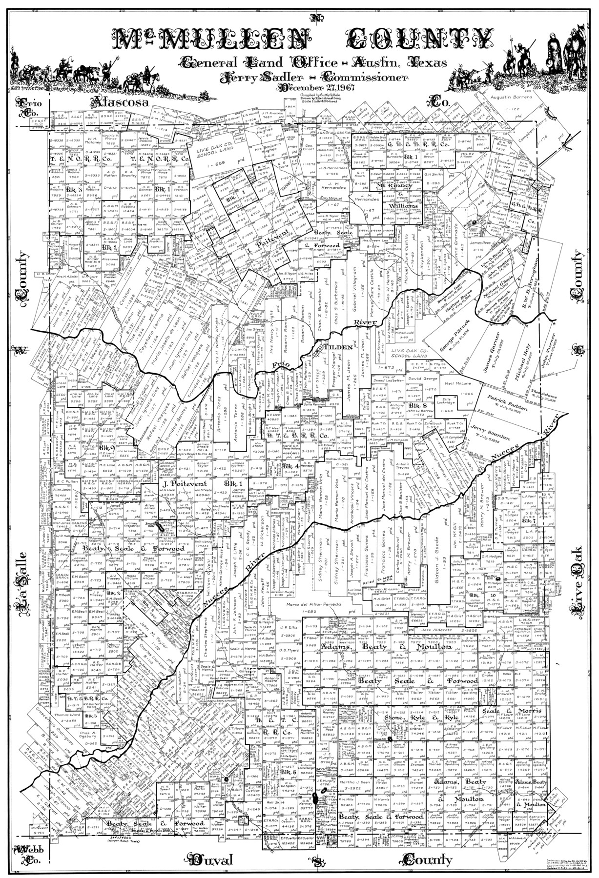
McMullen County
-
Map/Doc
77363
-
Collection
General Map Collection
-
Object Dates
1967/12/27 (Creation Date)
-
People and Organizations
Curtis R. Hale (Compiler)
Eltea Armstrong (Draftsman)
-
Counties
McMullen
-
Subjects
County
-
Height x Width
40.7 x 27.8 inches
103.4 x 70.6 cm
Part of: General Map Collection
Flight Mission No. DCL-7C, Frame 67, Kenedy County

Print $20.00
- Digital $50.00
Flight Mission No. DCL-7C, Frame 67, Kenedy County
1943
Size 15.5 x 15.3 inches
Map/Doc 86053
Brazoria County Rolled Sketch 25

Print $40.00
- Digital $50.00
Brazoria County Rolled Sketch 25
1935
Size 50.8 x 33.5 inches
Map/Doc 8928
Colorado County Sketch File 7

Print $4.00
- Digital $50.00
Colorado County Sketch File 7
1862
Size 13.1 x 8.0 inches
Map/Doc 18925
Houston Co[unty]
![78409, Houston Co[unty], General Map Collection](https://historictexasmaps.com/wmedia_w700/maps/78409.tif.jpg)
Print $20.00
- Digital $50.00
Houston Co[unty]
1896
Size 47.4 x 47.7 inches
Map/Doc 78409
Cherokee County Working Sketch 13

Print $20.00
- Digital $50.00
Cherokee County Working Sketch 13
1957
Size 46.5 x 43.8 inches
Map/Doc 67968
Brewster County Working Sketch 106

Print $20.00
- Digital $50.00
Brewster County Working Sketch 106
1980
Size 43.3 x 31.8 inches
Map/Doc 67706
Chambers County Rolled Sketch 25

Print $20.00
- Digital $50.00
Chambers County Rolled Sketch 25
1944
Size 33.9 x 31.5 inches
Map/Doc 8618
Flight Mission No. CGI-4N, Frame 21, Cameron County

Print $20.00
- Digital $50.00
Flight Mission No. CGI-4N, Frame 21, Cameron County
1954
Size 18.5 x 22.2 inches
Map/Doc 84654
Webb County Working Sketch 44

Print $20.00
- Digital $50.00
Webb County Working Sketch 44
1943
Size 26.0 x 27.4 inches
Map/Doc 72409
Brewster County Rolled Sketch 152

Print $20.00
- Digital $50.00
Brewster County Rolled Sketch 152
1996
Size 28.0 x 36.5 inches
Map/Doc 5319
Gonzales County Working Sketch 4b

Print $20.00
- Digital $50.00
Gonzales County Working Sketch 4b
1979
Size 21.2 x 27.3 inches
Map/Doc 63220

You may also like
Capitol Land Reservation

Print $20.00
- Digital $50.00
Capitol Land Reservation
1880
Size 27.1 x 34.4 inches
Map/Doc 10746
Flight Mission No. DQN-2K, Frame 28, Calhoun County

Print $20.00
- Digital $50.00
Flight Mission No. DQN-2K, Frame 28, Calhoun County
1953
Size 18.6 x 22.2 inches
Map/Doc 84235
Clay County Boundary File 8

Print $18.00
- Digital $50.00
Clay County Boundary File 8
Size 13.3 x 8.2 inches
Map/Doc 51384
Howard County Sketch File 8

Print $3.00
- Digital $50.00
Howard County Sketch File 8
Size 20.8 x 18.7 inches
Map/Doc 11796
[Surveys in the Bexar District along the Frio River]
![315, [Surveys in the Bexar District along the Frio River], General Map Collection](https://historictexasmaps.com/wmedia_w700/maps/315.tif.jpg)
Print $2.00
- Digital $50.00
[Surveys in the Bexar District along the Frio River]
1847
Size 15.8 x 9.2 inches
Map/Doc 315
Outer Continental Shelf Leasing Maps (Texas Offshore Operations)

Print $20.00
- Digital $50.00
Outer Continental Shelf Leasing Maps (Texas Offshore Operations)
Size 21.0 x 15.2 inches
Map/Doc 75840
Nueces County Sketch File 18

Print $4.00
- Digital $50.00
Nueces County Sketch File 18
1874
Size 10.2 x 7.2 inches
Map/Doc 32549
General Highway Map, Hemphill County, Texas

Print $20.00
General Highway Map, Hemphill County, Texas
1940
Size 18.2 x 24.8 inches
Map/Doc 79124
[Public Domain Surrounded by Blocks Z, C4, C3, A2, 1]
![92427, [Public Domain Surrounded by Blocks Z, C4, C3, A2, 1], Twichell Survey Records](https://historictexasmaps.com/wmedia_w700/maps/92427-1.tif.jpg)
Print $20.00
- Digital $50.00
[Public Domain Surrounded by Blocks Z, C4, C3, A2, 1]
Size 22.5 x 26.3 inches
Map/Doc 92427
Culberson County Working Sketch 52

Print $20.00
- Digital $50.00
Culberson County Working Sketch 52
1972
Size 37.3 x 39.5 inches
Map/Doc 68506
Flight Mission No. DQO-3K, Frame 37, Galveston County

Print $20.00
- Digital $50.00
Flight Mission No. DQO-3K, Frame 37, Galveston County
1952
Size 18.7 x 22.6 inches
Map/Doc 85078
[Sketch showing School Lands]
![90286, [Sketch showing School Lands], Twichell Survey Records](https://historictexasmaps.com/wmedia_w700/maps/90286-1.tif.jpg)
Print $20.00
- Digital $50.00
[Sketch showing School Lands]
Size 24.1 x 18.1 inches
Map/Doc 90286