Chambers County Rolled Sketch 25
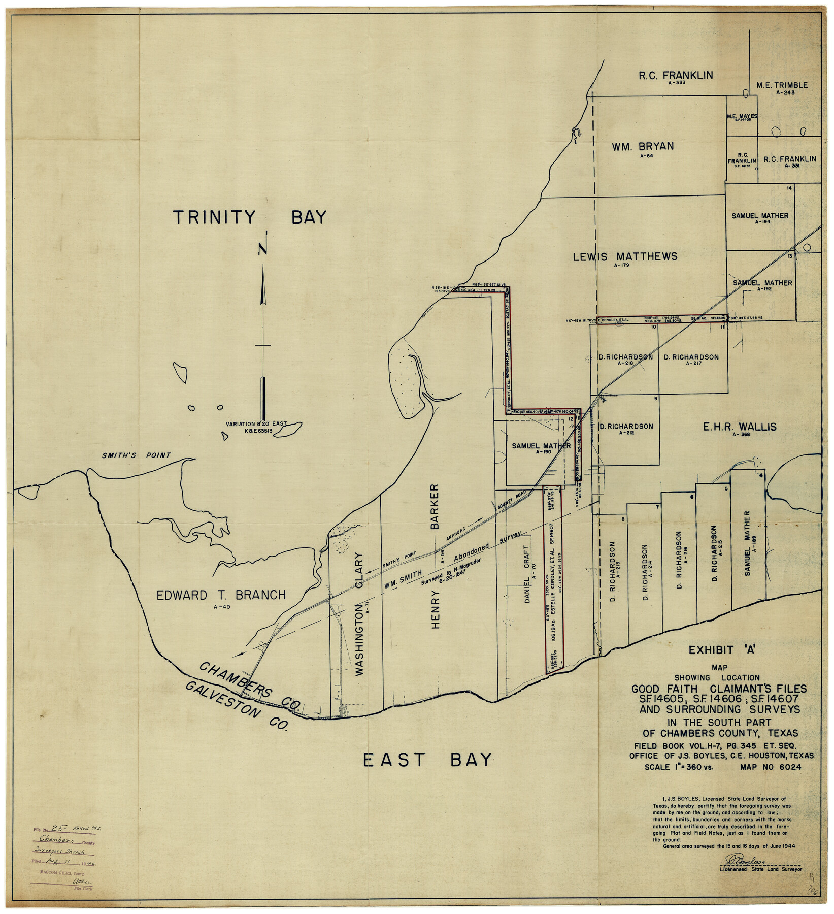
Exhibit 'A' - Map showing location Good Faith Claimant's files SF-14605, SF-14606, SF-14607 and surrounding surveys in the south part of Chambers County, Texas
-
Map/Doc
8618
-
Collection
General Map Collection
-
Object Dates
6/16/1944 (Creation Date)
8/11/1944 (File Date)
-
People and Organizations
J.S. Boyles (Surveyor/Engineer)
-
Counties
Chambers
-
Subjects
Surveying Rolled Sketch
-
Height x Width
33.9 x 31.5 inches
86.1 x 80.0 cm
-
Medium
van dyke/brownline/sepia
-
Scale
1" = 360 varas
-
Comments
See Chambers County Rolled Sketch 25A (8617) for Exhibit 'B'.
Related maps
Chambers County Rolled Sketch 25A

Print $20.00
- Digital $50.00
Chambers County Rolled Sketch 25A
1944
Size 41.2 x 34.5 inches
Map/Doc 8617
Part of: General Map Collection
Trinity County Sketch File 28

Print $22.00
- Digital $50.00
Trinity County Sketch File 28
Size 7.0 x 19.7 inches
Map/Doc 38564
Hemphill County Rolled Sketch 18

Print $20.00
- Digital $50.00
Hemphill County Rolled Sketch 18
Size 23.6 x 35.0 inches
Map/Doc 6200
Lynn County Sketch File 2

Print $5.00
- Digital $50.00
Lynn County Sketch File 2
1902
Size 11.6 x 17.1 inches
Map/Doc 30447
Map of Chicago, Rock Island & Texas Railroad

Print $40.00
- Digital $50.00
Map of Chicago, Rock Island & Texas Railroad
1892
Size 23.9 x 122.0 inches
Map/Doc 64442
Zapata County Sketch File 3

Print $6.00
- Digital $50.00
Zapata County Sketch File 3
1883
Size 16.3 x 10.7 inches
Map/Doc 40904
Leon County Rolled Sketch 25

Print $20.00
- Digital $50.00
Leon County Rolled Sketch 25
Size 47.3 x 36.2 inches
Map/Doc 9434
Frio County Working Sketch 12

Print $40.00
- Digital $50.00
Frio County Working Sketch 12
1953
Size 52.8 x 39.9 inches
Map/Doc 69286
Tarrant County Sketch File 12

Print $4.00
- Digital $50.00
Tarrant County Sketch File 12
1859
Size 10.1 x 8.3 inches
Map/Doc 37703
Gray's New Map of Texas and the Indian Territory

Print $20.00
- Digital $50.00
Gray's New Map of Texas and the Indian Territory
1876
Size 17.6 x 28.6 inches
Map/Doc 97282
Pecos County Sketch File 55

Print $20.00
- Digital $50.00
Pecos County Sketch File 55
Size 43.1 x 20.4 inches
Map/Doc 10570
Montague County Sketch File 12

Print $4.00
- Digital $50.00
Montague County Sketch File 12
Size 11.4 x 8.2 inches
Map/Doc 31736
Harris County NRC Article 33.136 Sketch 6

Print $21.00
- Digital $50.00
Harris County NRC Article 33.136 Sketch 6
2003
Size 23.1 x 34.8 inches
Map/Doc 78664
You may also like
Pecos County Rolled Sketch 71

Print $20.00
- Digital $50.00
Pecos County Rolled Sketch 71
Size 21.9 x 47.6 inches
Map/Doc 9703
Cooke County Sketch File 23

Print $4.00
- Digital $50.00
Cooke County Sketch File 23
1870
Size 12.7 x 8.0 inches
Map/Doc 19270
[Panhandle Counties]
![90796, [Panhandle Counties], Twichell Survey Records](https://historictexasmaps.com/wmedia_w700/maps/90796-1.tif.jpg)
Print $20.00
- Digital $50.00
[Panhandle Counties]
1908
Size 18.4 x 14.8 inches
Map/Doc 90796
Map of Erath County

Print $40.00
- Digital $50.00
Map of Erath County
1896
Size 50.4 x 45.1 inches
Map/Doc 7820
Cass County Working Sketch 33

Print $20.00
- Digital $50.00
Cass County Working Sketch 33
1982
Size 27.4 x 26.6 inches
Map/Doc 67936
Brazoria County Sketch File 58

Print $30.00
- Digital $50.00
Brazoria County Sketch File 58
1992
Size 11.5 x 9.0 inches
Map/Doc 15382
Coleman County Sketch File 16

Print $4.00
- Digital $50.00
Coleman County Sketch File 16
1849
Size 9.6 x 8.3 inches
Map/Doc 18683
[Aerial photograph from Carancahua Bend of Caney Creek to Cedar Lake]
![78639, [Aerial photograph from Carancahua Bend of Caney Creek to Cedar Lake], General Map Collection](https://historictexasmaps.com/wmedia_w700/maps/78639.tif.jpg)
Print $20.00
- Digital $50.00
[Aerial photograph from Carancahua Bend of Caney Creek to Cedar Lake]
1991
Size 24.4 x 34.0 inches
Map/Doc 78639
Val Verde County Rolled Sketch 1

Print $40.00
- Digital $50.00
Val Verde County Rolled Sketch 1
1885
Size 69.8 x 39.1 inches
Map/Doc 10068
Map of Tarrant County

Print $20.00
- Digital $50.00
Map of Tarrant County
1867
Size 30.0 x 19.3 inches
Map/Doc 4066
Coast Chart No. 210 - Aransas Pass and Corpus Christi Bay with the coast to latitude 27° 12', Texas

Print $20.00
- Digital $50.00
Coast Chart No. 210 - Aransas Pass and Corpus Christi Bay with the coast to latitude 27° 12', Texas
1907
Size 18.4 x 24.1 inches
Map/Doc 73453
Flight Mission No. CRC-3R, Frame 14, Chambers County

Print $20.00
- Digital $50.00
Flight Mission No. CRC-3R, Frame 14, Chambers County
1956
Size 18.6 x 22.3 inches
Map/Doc 84788