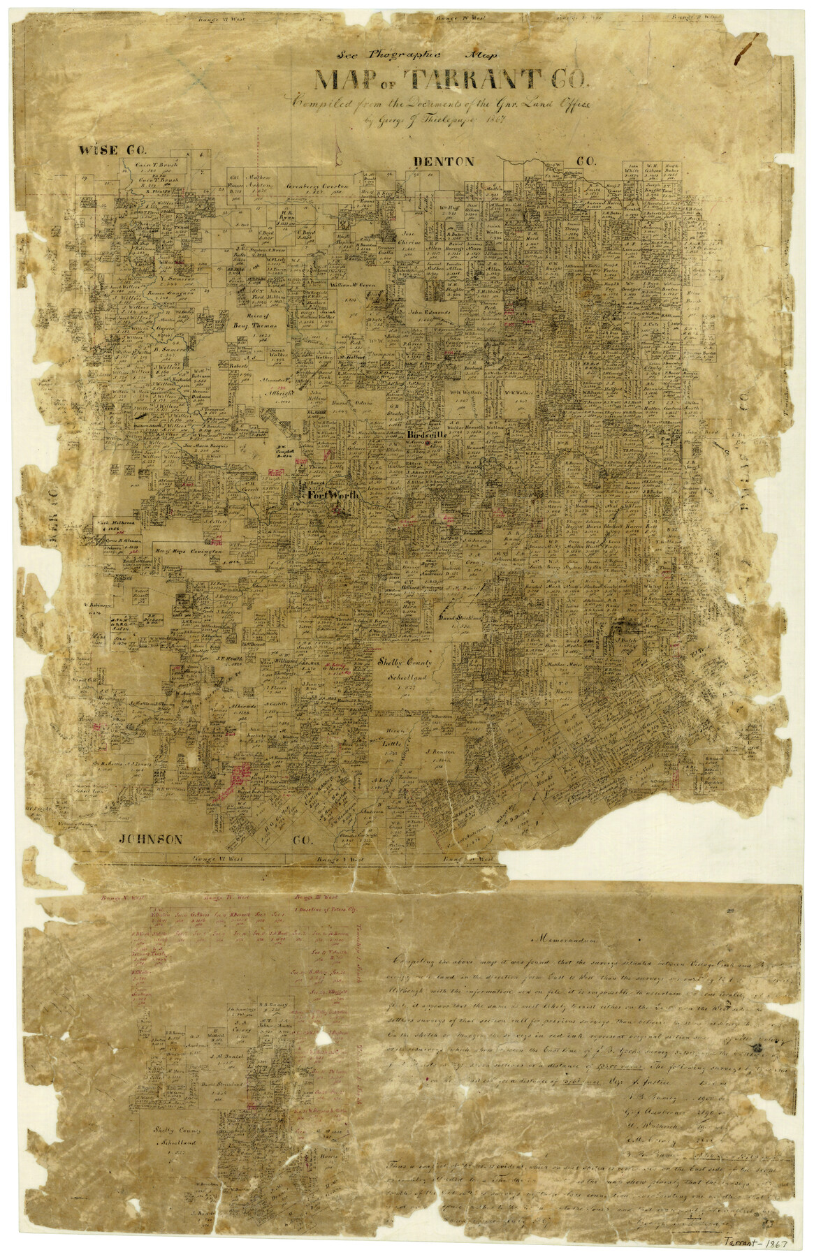
Map of Tarrant County
-
Map/Doc
4066
-
Collection
General Map Collection
-
Object Dates
1867 (Creation Date)
-
People and Organizations
Texas General Land Office (Publisher)
George J. Thielepape (Compiler)
-
Counties
Tarrant
-
Subjects
County
-
Height x Width
30.0 x 19.3 inches
76.2 x 49.0 cm
-
Features
Village Creek
Sycamore Creek
Clear Fork Creek
Turkey Creek
South Fork of Clear Fork Creek
Rock Creek
Little Red Bear Creek
Mustang Creek
Stone Deer Creek
Caddo Creek
Fish Creek
Little Fossil Creek
Miller Creek
West Ford [of Bear Creek]
Mary's Creek
South Fork of Turkey Creek
Shoal Creek
Deer Creek
East Fork [of Village Creek]
Walker's Branch [of Trinity River]
Blue Mound
Walnut Creek
Gilmore Creek
Little Bear Creek
Big Fossil Creek
Cottonwood Creek
Ash Creek
Silver Creek
Birdsville
Henrietta Creek
Bear Creek
Trinity River
Marine Creek
Fort Worth
Trading House Creek
West Fork of Trinity River
Rush Creek
Allum Branch [of Trinity River]
Part of: General Map Collection
Flight Mission No. DAG-21K, Frame 132, Matagorda County

Print $20.00
- Digital $50.00
Flight Mission No. DAG-21K, Frame 132, Matagorda County
1952
Size 18.6 x 22.5 inches
Map/Doc 86458
[FT. W. & R. G. Ry. Right of Way Map, Winchell to Brady, McCulloch County, Texas]
![61411, [FT. W. & R. G. Ry. Right of Way Map, Winchell to Brady, McCulloch County, Texas], General Map Collection](https://historictexasmaps.com/wmedia_w700/maps/61411.tif.jpg)
Print $20.00
- Digital $50.00
[FT. W. & R. G. Ry. Right of Way Map, Winchell to Brady, McCulloch County, Texas]
1918
Size 37.0 x 26.9 inches
Map/Doc 61411
Kinney County

Print $40.00
- Digital $50.00
Kinney County
1955
Size 51.9 x 48.2 inches
Map/Doc 95559
Orange County, West Half of Sabine River Showing Leases 5 and 6

Print $20.00
- Digital $50.00
Orange County, West Half of Sabine River Showing Leases 5 and 6
1957
Size 30.6 x 34.3 inches
Map/Doc 1934
A General Map of North America drawn from the best surveys

Print $20.00
- Digital $50.00
A General Map of North America drawn from the best surveys
1795
Map/Doc 93944
Leon County Rolled Sketch 31A

Print $20.00
- Digital $50.00
Leon County Rolled Sketch 31A
1995
Size 38.9 x 15.4 inches
Map/Doc 6615
Flight Mission No. CUG-1P, Frame 110, Kleberg County

Print $20.00
- Digital $50.00
Flight Mission No. CUG-1P, Frame 110, Kleberg County
1956
Size 18.5 x 22.2 inches
Map/Doc 86160
Wharton County Sketch File A4

Print $11.00
- Digital $50.00
Wharton County Sketch File A4
1904
Size 11.0 x 8.4 inches
Map/Doc 39981
Hunt County Boundary File 10a

Print $40.00
- Digital $50.00
Hunt County Boundary File 10a
Size 42.1 x 10.5 inches
Map/Doc 55262
Map of Harrison County

Print $20.00
- Digital $50.00
Map of Harrison County
1880
Size 20.4 x 21.8 inches
Map/Doc 1119
Calhoun County Rolled Sketch 30

Print $20.00
- Digital $50.00
Calhoun County Rolled Sketch 30
1974
Size 18.6 x 27.3 inches
Map/Doc 5487

You may also like
Padre Island National Seashore

Print $4.00
- Digital $50.00
Padre Island National Seashore
Size 16.2 x 22.1 inches
Map/Doc 60534
Travis County Sketch File 21

Print $4.00
- Digital $50.00
Travis County Sketch File 21
1875
Size 12.8 x 8.4 inches
Map/Doc 38325
Flight Mission No. BRA-7M, Frame 26, Jefferson County

Print $20.00
- Digital $50.00
Flight Mission No. BRA-7M, Frame 26, Jefferson County
1953
Size 18.4 x 22.2 inches
Map/Doc 85477
The Range and Ranch Cattle Area of the United States

Print $20.00
- Digital $50.00
The Range and Ranch Cattle Area of the United States
1884
Size 26.4 x 27.2 inches
Map/Doc 94077
La Salle County Sketch File 11

Print $20.00
- Digital $50.00
La Salle County Sketch File 11
1877
Size 12.7 x 8.1 inches
Map/Doc 29460
[Miller Day Ranch]
![81517, [Miller Day Ranch], General Map Collection](https://historictexasmaps.com/wmedia_w700/maps/81517.tif.jpg)
Print $40.00
- Digital $50.00
[Miller Day Ranch]
1995
Size 60.6 x 38.0 inches
Map/Doc 81517
Sherman County

Print $20.00
- Digital $50.00
Sherman County
1889
Size 22.3 x 19.0 inches
Map/Doc 4036
Dimmit County Sketch File 57

Print $6.00
- Digital $50.00
Dimmit County Sketch File 57
1941
Size 14.3 x 8.8 inches
Map/Doc 21190
Presidio County Working Sketch 137

Print $20.00
- Digital $50.00
Presidio County Working Sketch 137
1990
Size 24.1 x 42.8 inches
Map/Doc 71815
Sketch in Crockett County, Texas

Print $20.00
- Digital $50.00
Sketch in Crockett County, Texas
Size 27.8 x 23.4 inches
Map/Doc 90474
Washington County Working Sketch Graphic Index

Print $20.00
- Digital $50.00
Washington County Working Sketch Graphic Index
1976
Size 31.3 x 46.8 inches
Map/Doc 76733
Old Miscellaneous File 7

Print $10.00
- Digital $50.00
Old Miscellaneous File 7
1848
Size 12.6 x 8.2 inches
Map/Doc 75422