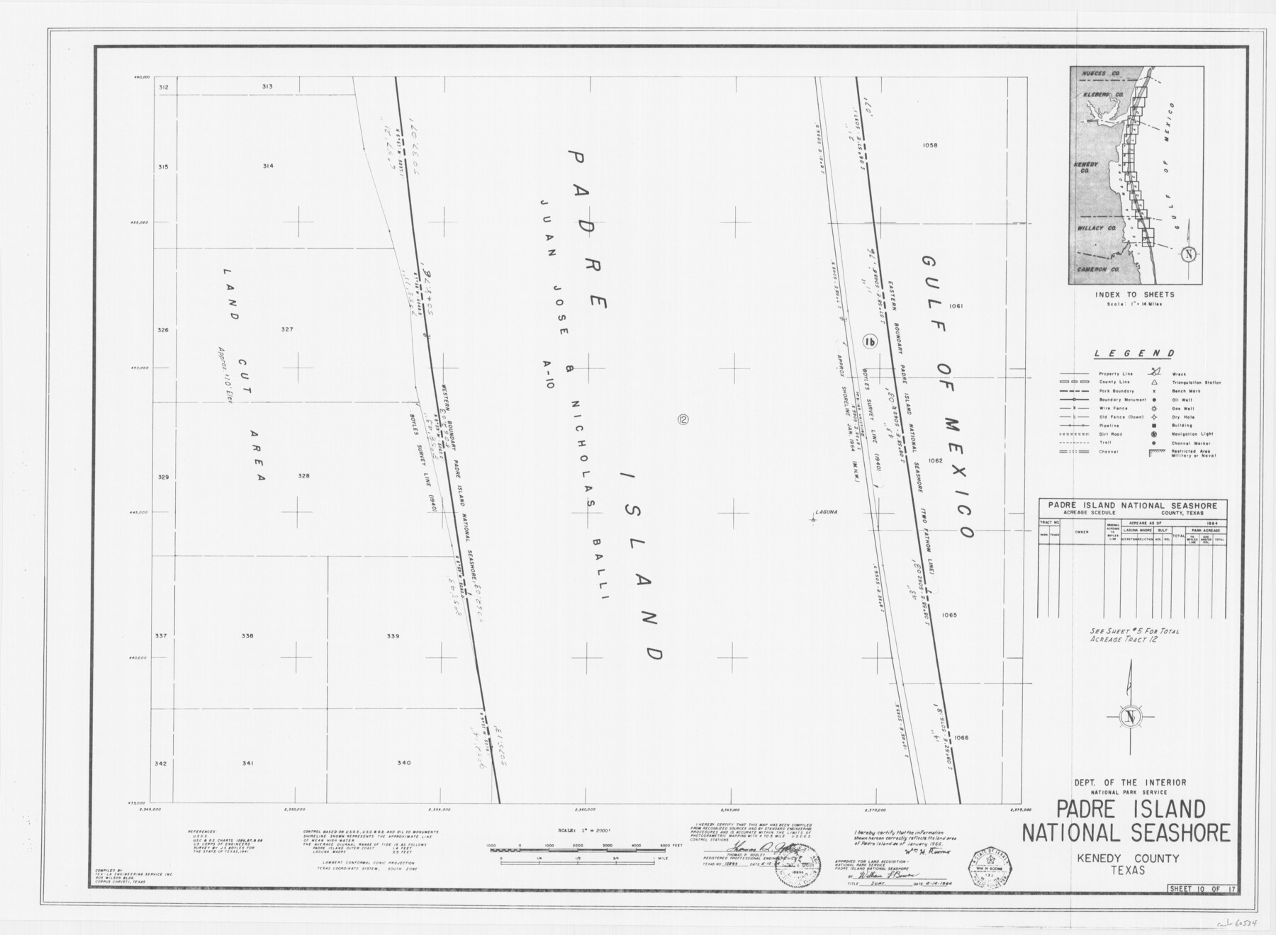
Padre Island National Seashore
17 survey plats of Padre Island National Seashore
N-2-125
-
Map/Doc
60534
-
Collection
General Map Collection
-
Counties
Kenedy
-
Height x Width
16.2 x 22.1 inches
41.1 x 56.1 cm
Part of: General Map Collection
University Land Field Notes for Blocks 29 through 33, Crockett County

University Land Field Notes for Blocks 29 through 33, Crockett County
Map/Doc 81715
Lampasas County Working Sketch 18

Print $20.00
- Digital $50.00
Lampasas County Working Sketch 18
1977
Size 46.1 x 44.0 inches
Map/Doc 70295
Map of Clay Co.

Print $40.00
- Digital $50.00
Map of Clay Co.
1896
Size 53.8 x 34.6 inches
Map/Doc 4910
Cameron County Boundary File 2

Print $60.00
- Digital $50.00
Cameron County Boundary File 2
Size 47.8 x 22.1 inches
Map/Doc 51095
Cameron County

Print $20.00
- Digital $50.00
Cameron County
1976
Size 30.9 x 38.1 inches
Map/Doc 77230
Rockwall County Boundary File 75

Print $18.00
- Digital $50.00
Rockwall County Boundary File 75
Size 9.0 x 11.7 inches
Map/Doc 58472
Atascosa County Sketch File 37

Print $40.00
- Digital $50.00
Atascosa County Sketch File 37
Size 17.6 x 12.9 inches
Map/Doc 13829
Pecos County Rolled Sketch 65

Print $20.00
- Digital $50.00
Pecos County Rolled Sketch 65
1928
Size 37.9 x 33.8 inches
Map/Doc 9699
Henderson County Boundary File 2

Print $12.00
- Digital $50.00
Henderson County Boundary File 2
Size 10.6 x 8.2 inches
Map/Doc 54650
Real County Working Sketch 44

Print $20.00
- Digital $50.00
Real County Working Sketch 44
1953
Size 28.3 x 24.3 inches
Map/Doc 71936
Erath County Working Sketch 35

Print $20.00
- Digital $50.00
Erath County Working Sketch 35
1973
Size 24.8 x 28.4 inches
Map/Doc 69116
Shackelford County Sketch File 15

Print $16.00
- Digital $50.00
Shackelford County Sketch File 15
1998
Size 14.2 x 8.8 inches
Map/Doc 62202
You may also like
Cameron County Sketch File 17

Print $24.00
- Digital $50.00
Cameron County Sketch File 17
2009
Size 11.0 x 8.5 inches
Map/Doc 95191
Yoakum County Sketch File 7

Print $6.00
- Digital $50.00
Yoakum County Sketch File 7
1906
Size 14.5 x 9.0 inches
Map/Doc 40750
Wheeler County Working Sketch 18

Print $20.00
- Digital $50.00
Wheeler County Working Sketch 18
1985
Size 38.0 x 41.8 inches
Map/Doc 72507
Copy of Surveyor's Field Book, Morris Browning - In Blocks 7, 5 & 4, I&GNRRCo., Hutchinson and Carson Counties, Texas

Print $2.00
- Digital $50.00
Copy of Surveyor's Field Book, Morris Browning - In Blocks 7, 5 & 4, I&GNRRCo., Hutchinson and Carson Counties, Texas
1888
Size 7.0 x 8.9 inches
Map/Doc 62268
Edwards County

Print $40.00
- Digital $50.00
Edwards County
1900
Size 56.4 x 27.3 inches
Map/Doc 87471
Eastland County Working Sketch 41

Print $20.00
- Digital $50.00
Eastland County Working Sketch 41
1975
Size 37.3 x 34.7 inches
Map/Doc 68822
Karnes County Working Sketch 6

Print $20.00
- Digital $50.00
Karnes County Working Sketch 6
1961
Size 23.3 x 27.5 inches
Map/Doc 66654
Hartley County Boundary File 3

Print $15.00
- Digital $50.00
Hartley County Boundary File 3
Size 6.7 x 16.5 inches
Map/Doc 54476
Terry County Working Sketch 2

Print $20.00
- Digital $50.00
Terry County Working Sketch 2
1952
Size 19.3 x 19.3 inches
Map/Doc 62107
Montgomery County Working Sketch 31

Print $20.00
- Digital $50.00
Montgomery County Working Sketch 31
Size 24.7 x 18.7 inches
Map/Doc 71138
Webb County Working Sketch 11

Print $20.00
- Digital $50.00
Webb County Working Sketch 11
1921
Size 17.8 x 16.3 inches
Map/Doc 72376
Working Sketch Armstrong County

Print $20.00
- Digital $50.00
Working Sketch Armstrong County
1909
Size 32.0 x 23.8 inches
Map/Doc 90264