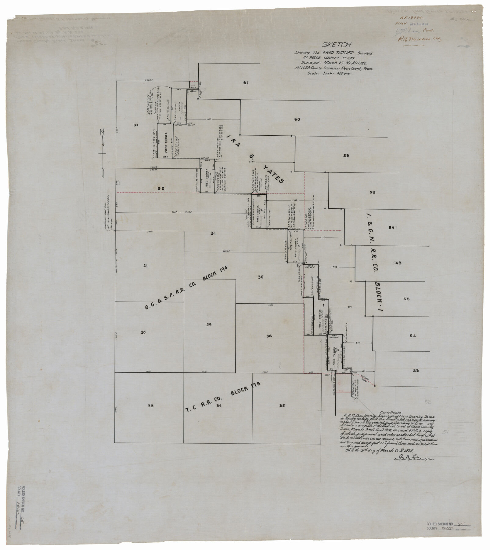
Pecos County Rolled Sketch 65
Sketch showing the Fred Turner surveys in Pecos County, Texas
-
Map/Doc
9699
-
Collection
General Map Collection
-
Object Dates
1928/3/30 (Survey Date)
1928/4/4 (File Date)
1928/3/31 (Creation Date)
-
People and Organizations
A.N. Lea (Surveyor/Engineer)
-
Counties
Pecos
-
Subjects
Surveying Rolled Sketch
-
Height x Width
37.9 x 33.8 inches
96.3 x 85.9 cm
-
Medium
linen, manuscript
-
Scale
1" = 400 varas
Part of: General Map Collection
Flight Mission No. BQY-15M, Frame 22, Harris County

Print $20.00
- Digital $50.00
Flight Mission No. BQY-15M, Frame 22, Harris County
1953
Size 18.6 x 22.3 inches
Map/Doc 85320
Kendall County Sketch File 15

Print $4.00
- Digital $50.00
Kendall County Sketch File 15
1860
Size 12.4 x 7.8 inches
Map/Doc 28703

Terrell County Sketch File 13

Print $20.00
- Digital $50.00
Terrell County Sketch File 13
1911
Size 13.7 x 20.4 inches
Map/Doc 12420
Atascosa County Sketch File 1

Print $8.00
- Digital $50.00
Atascosa County Sketch File 1
Size 8.1 x 6.1 inches
Map/Doc 13718
South Part of Brewster Co.

Print $40.00
- Digital $50.00
South Part of Brewster Co.
1955
Size 48.2 x 40.5 inches
Map/Doc 73089
San Jacinto County Rolled Sketch 6

Print $20.00
- Digital $50.00
San Jacinto County Rolled Sketch 6
Size 42.1 x 43.5 inches
Map/Doc 8361
Aransas Pass to Baffin Bay

Print $20.00
- Digital $50.00
Aransas Pass to Baffin Bay
1986
Size 44.7 x 35.7 inches
Map/Doc 73421
Navasota River, Grayson Crossing Sheet

Print $20.00
- Digital $50.00
Navasota River, Grayson Crossing Sheet
1937
Size 42.8 x 21.1 inches
Map/Doc 65071
Aransas County Rolled Sketch 6

Print $20.00
- Digital $50.00
Aransas County Rolled Sketch 6
1953
Size 19.6 x 18.8 inches
Map/Doc 77190

La Salle County Sketch File 16

Print $5.00
- Digital $50.00
La Salle County Sketch File 16
1883
Size 9.3 x 9.7 inches
Map/Doc 29487
You may also like
The Republic County of Jefferson. Spring 1842

Print $20.00
The Republic County of Jefferson. Spring 1842
2020
Size 22.6 x 21.7 inches
Map/Doc 96200
Harris County Working Sketch 43

Print $20.00
- Digital $50.00
Harris County Working Sketch 43
1940
Size 26.8 x 22.1 inches
Map/Doc 65935

Wichita County Sketch File 19

Print $20.00
- Digital $50.00
Wichita County Sketch File 19
Size 21.9 x 22.5 inches
Map/Doc 12681
Callahan County Working Sketch Graphic Index

Print $20.00
- Digital $50.00
Callahan County Working Sketch Graphic Index
1969
Size 41.3 x 33.4 inches
Map/Doc 76485
South Part Crockett County

Print $40.00
- Digital $50.00
South Part Crockett County
1977
Size 39.1 x 51.2 inches
Map/Doc 95471
King County Sketch File 10

Print $24.00
- Digital $50.00
King County Sketch File 10
1902
Size 14.2 x 8.7 inches
Map/Doc 29083
Schleicher County Sketch File 22

Print $9.00
- Digital $50.00
Schleicher County Sketch File 22
1927
Size 12.8 x 11.7 inches
Map/Doc 36512
Flight Mission No. DAG-22K, Frame 87, Matagorda County

Print $20.00
- Digital $50.00
Flight Mission No. DAG-22K, Frame 87, Matagorda County
1953
Size 18.6 x 22.4 inches
Map/Doc 86471

Hardin County Sketch File 63

Print $10.00
- Digital $50.00
Hardin County Sketch File 63
Size 11.3 x 8.8 inches
Map/Doc 25238
San Luis Pass to East Matagorda Bay

Print $20.00
- Digital $50.00
San Luis Pass to East Matagorda Bay
1964
Size 34.7 x 46.6 inches
Map/Doc 69964