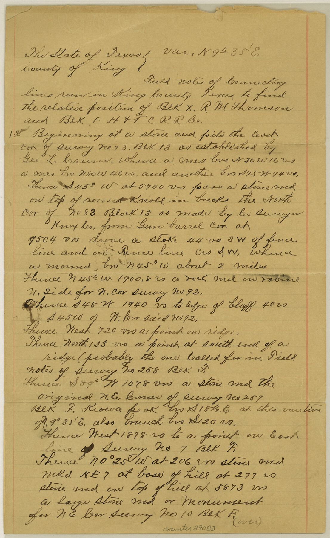
King County Sketch File 10
[Connecting lines to Blocks X and F, and sketch of Tongue River Ranch, King County, Texas]
-
Map/Doc
29083
-
Collection
General Map Collection
-
Object Dates
5/15/1902 (Creation Date)
5/20/1902 (File Date)
5/13/1902 (Survey Date)
8/1902 (Survey Date)
9/1902 (Survey Date)
-
People and Organizations
George L. Crum (Surveyor/Engineer)
J.J. Goodfellow (Surveyor/Engineer)
G.W. Moore (Surveyor/Engineer)
-
Counties
King Dickens Motley Cottle
-
Subjects
Surveying Sketch File
-
Height x Width
14.2 x 8.7 inches
36.1 x 22.1 cm
-
Medium
multi-page, multi-format
-
Scale
1" = 2000 varas
-
Features
Kiowa Peak
Tee Pee Creek
Tongue River Ranch
Salt Creek
Bluff Creek
China Cannon [sic]
Torrents Creek
T-41 Creek
Tongue River
North Prong of Buford's Creek
South Prong of Buford's Creek
North Wichata [sic] River
Cottonwood Creek
Anny Springs
Buford's Bayou
Part of: General Map Collection
Dallas County Working Sketch 16

Print $20.00
- Digital $50.00
Dallas County Working Sketch 16
1981
Size 15.7 x 12.0 inches
Map/Doc 68582
Andrews County Working Sketch 33

Print $20.00
- Digital $50.00
Andrews County Working Sketch 33
1990
Size 32.9 x 29.7 inches
Map/Doc 67079
Colorado County Sketch File 33

Print $44.00
- Digital $50.00
Colorado County Sketch File 33
1847
Size 13.2 x 16.2 inches
Map/Doc 18988
Terry County Sketch File 3

Print $20.00
- Digital $50.00
Terry County Sketch File 3
1948
Size 16.2 x 39.0 inches
Map/Doc 10390
Map of Travis County

Print $20.00
- Digital $50.00
Map of Travis County
Size 23.5 x 24.2 inches
Map/Doc 4090
Hardin County Working Sketch 44

Print $40.00
- Digital $50.00
Hardin County Working Sketch 44
1954
Size 53.2 x 39.9 inches
Map/Doc 65610
Eastland County Working Sketch 31

Print $20.00
- Digital $50.00
Eastland County Working Sketch 31
1955
Size 33.9 x 33.9 inches
Map/Doc 68812
Clay County Boundary File 3

Print $4.00
- Digital $50.00
Clay County Boundary File 3
Size 11.2 x 8.6 inches
Map/Doc 51364
Bandera County Working Sketch 16d

Print $20.00
- Digital $50.00
Bandera County Working Sketch 16d
1941
Size 19.1 x 23.2 inches
Map/Doc 67612
Nautical Chart 892-SC - Intracoastal Waterway - Carlos Bay to Redfish Bay including Copano Bay, Texas

Print $40.00
- Digital $50.00
Nautical Chart 892-SC - Intracoastal Waterway - Carlos Bay to Redfish Bay including Copano Bay, Texas
1972
Size 16.6 x 52.1 inches
Map/Doc 73441
Reeves County Rolled Sketch 24

Print $20.00
- Digital $50.00
Reeves County Rolled Sketch 24
1982
Size 40.6 x 28.4 inches
Map/Doc 7492
Map of Abilene

Print $20.00
- Digital $50.00
Map of Abilene
1885
Size 24.6 x 27.4 inches
Map/Doc 3042
You may also like
Flight Mission No. DQO-1K, Frame 114, Galveston County

Print $20.00
- Digital $50.00
Flight Mission No. DQO-1K, Frame 114, Galveston County
1952
Size 18.8 x 22.5 inches
Map/Doc 84992
Gregg County Boundary File 2

Print $8.00
- Digital $50.00
Gregg County Boundary File 2
Size 8.8 x 3.7 inches
Map/Doc 53984
Henderson County Working Sketch 34

Print $20.00
- Digital $50.00
Henderson County Working Sketch 34
1965
Size 22.9 x 35.8 inches
Map/Doc 66167
Map of Fannin County

Print $20.00
- Digital $50.00
Map of Fannin County
1866
Size 21.9 x 18.1 inches
Map/Doc 3534
United States Population Distribution by County and Territory, per the U.S. Census of 1870

United States Population Distribution by County and Territory, per the U.S. Census of 1870
2025
Size 8.5 x 11.0 inches
Map/Doc 97479
Llano County Sketch File 13

Print $4.00
- Digital $50.00
Llano County Sketch File 13
1891
Size 9.2 x 15.3 inches
Map/Doc 30387
Fort Worth, Tex. "The Queen of the Prairies," County Seat of Tarrant County

Print $20.00
Fort Worth, Tex. "The Queen of the Prairies," County Seat of Tarrant County
1886
Size 26.0 x 33.3 inches
Map/Doc 89082
Ward County Working Sketch 28

Print $40.00
- Digital $50.00
Ward County Working Sketch 28
1964
Size 60.9 x 29.1 inches
Map/Doc 72334
Foard County Aerial Photograph Index Sheet 3

Print $20.00
- Digital $50.00
Foard County Aerial Photograph Index Sheet 3
1950
Size 20.3 x 18.9 inches
Map/Doc 83690
Terrell County Working Sketch 47

Print $40.00
- Digital $50.00
Terrell County Working Sketch 47
1958
Size 59.0 x 43.0 inches
Map/Doc 62140
Map of Sabine County

Print $20.00
- Digital $50.00
Map of Sabine County
1896
Size 25.8 x 17.9 inches
Map/Doc 63012
Flight Mission No. CRE-1R, Frame 63, Jackson County

Print $20.00
- Digital $50.00
Flight Mission No. CRE-1R, Frame 63, Jackson County
1956
Size 18.6 x 18.9 inches
Map/Doc 85326