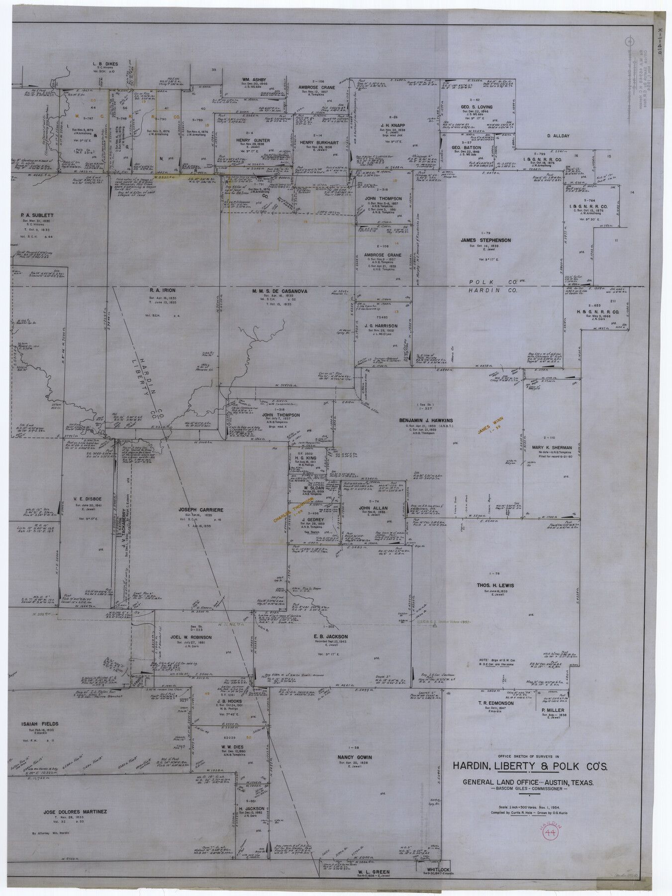
Hardin County Working Sketch 44
K-1-41a
-
Map/Doc
65610
-
Collection
General Map Collection
-
Object Dates
11/1/1954 (Creation Date)
-
People and Organizations
Curtis R. Hale (Compiler)
Otto G. Kurio (Draftsman)
-
Counties
Hardin Polk Liberty
-
Subjects
Surveying Working Sketch
-
Height x Width
53.2 x 39.9 inches
135.1 x 101.4 cm
-
Scale
1" = 500 varas
-
Comments
segment 1 of 2; for segment 2 see map 69764.
Related maps
Hardin County Working Sketch 44

Print $40.00
- Digital $50.00
Hardin County Working Sketch 44
1954
Size 53.1 x 39.5 inches
Map/Doc 69764
Part of: General Map Collection
El Paso County Rolled Sketch 18

Print $20.00
- Digital $50.00
El Paso County Rolled Sketch 18
Size 30.0 x 33.4 inches
Map/Doc 5822
Reeves County

Print $40.00
- Digital $50.00
Reeves County
1915
Size 48.4 x 38.7 inches
Map/Doc 66999

Boundary Between the United States & Mexico Agreed Upon by the Joint Commission under the Treaty of Guadalupe Hidalgo

Print $4.00
- Digital $50.00
Boundary Between the United States & Mexico Agreed Upon by the Joint Commission under the Treaty of Guadalupe Hidalgo
1853
Size 24.0 x 17.6 inches
Map/Doc 65391
Denton County Rolled Sketch 3

Print $20.00
- Digital $50.00
Denton County Rolled Sketch 3
1959
Size 39.1 x 23.9 inches
Map/Doc 5700
Cottle County Sketch File 9

Print $6.00
- Digital $50.00
Cottle County Sketch File 9
1893
Size 16.4 x 10.8 inches
Map/Doc 19487
Map of Lavaca County

Print $20.00
- Digital $50.00
Map of Lavaca County
1853
Size 20.1 x 20.4 inches
Map/Doc 3801
Flight Mission No. BRE-2P, Frame 20, Nueces County

Print $20.00
- Digital $50.00
Flight Mission No. BRE-2P, Frame 20, Nueces County
1956
Size 17.1 x 19.8 inches
Map/Doc 86729

Tyler County Sketch File 17a

Print $4.00
- Digital $50.00
Tyler County Sketch File 17a
1853
Size 6.6 x 8.0 inches
Map/Doc 38664
Terrell County Rolled Sketch 35

Print $20.00
- Digital $50.00
Terrell County Rolled Sketch 35
1938
Size 20.5 x 39.3 inches
Map/Doc 7940
Williamson County Working Sketch 14

Print $20.00
- Digital $50.00
Williamson County Working Sketch 14
1982
Size 22.0 x 28.3 inches
Map/Doc 72574
You may also like
Jeff Davis County Rolled Sketch 44

Print $20.00
- Digital $50.00
Jeff Davis County Rolled Sketch 44
2014
Size 19.8 x 34.7 inches
Map/Doc 94243
Hockley County Boundary File 3

Print $12.00
- Digital $50.00
Hockley County Boundary File 3
Size 4.1 x 8.6 inches
Map/Doc 54804
Marion County Rolled Sketch JRC

Print $20.00
- Digital $50.00
Marion County Rolled Sketch JRC
1953
Size 19.4 x 20.5 inches
Map/Doc 6662
Wilson County Sketch File 13

Print $4.00
- Digital $50.00
Wilson County Sketch File 13
1873
Size 10.2 x 8.0 inches
Map/Doc 40429
Refugio County Sketch File 6

Print $4.00
- Digital $50.00
Refugio County Sketch File 6
1856
Size 8.0 x 13.7 inches
Map/Doc 35249
Terrell County Rolled Sketch 30

Print $40.00
- Digital $50.00
Terrell County Rolled Sketch 30
1931
Size 38.9 x 49.0 inches
Map/Doc 10735
Gulf Oil Corp. Fishgide - Matagorda

Gulf Oil Corp. Fishgide - Matagorda
1960
Size 12.4 x 22.4 inches
Map/Doc 75976
General Highway Map. Detail of Cities and Towns in Kinney County, Uvalde County [Uvalde and vicinity, Sabinal, and Brackettville and vicinity]
![79163, General Highway Map. Detail of Cities and Towns in Kinney County, Uvalde County [Uvalde and vicinity, Sabinal, and
Brackettville and vicinity], Texas State Library and Archives](https://historictexasmaps.com/wmedia_w700/maps/79163.tif.jpg)
Print $20.00
General Highway Map. Detail of Cities and Towns in Kinney County, Uvalde County [Uvalde and vicinity, Sabinal, and Brackettville and vicinity]
1940
Size 18.5 x 24.7 inches
Map/Doc 79163
[Cotton Belt, St. Louis Southwestern Railway of Texas, Alignment through Smith County]
![64382, [Cotton Belt, St. Louis Southwestern Railway of Texas, Alignment through Smith County], General Map Collection](https://historictexasmaps.com/wmedia_w700/maps/64382.tif.jpg)
Print $20.00
- Digital $50.00
[Cotton Belt, St. Louis Southwestern Railway of Texas, Alignment through Smith County]
1903
Size 21.8 x 29.1 inches
Map/Doc 64382
Reeves County Working Sketch 42

Print $20.00
- Digital $50.00
Reeves County Working Sketch 42
1973
Size 46.3 x 31.5 inches
Map/Doc 63485
Gillespie County Working Sketch 7

Print $40.00
- Digital $50.00
Gillespie County Working Sketch 7
1984
Size 57.5 x 43.2 inches
Map/Doc 63170
Gregg County Working Sketch 14

Print $20.00
- Digital $50.00
Gregg County Working Sketch 14
1941
Size 29.7 x 39.5 inches
Map/Doc 63281