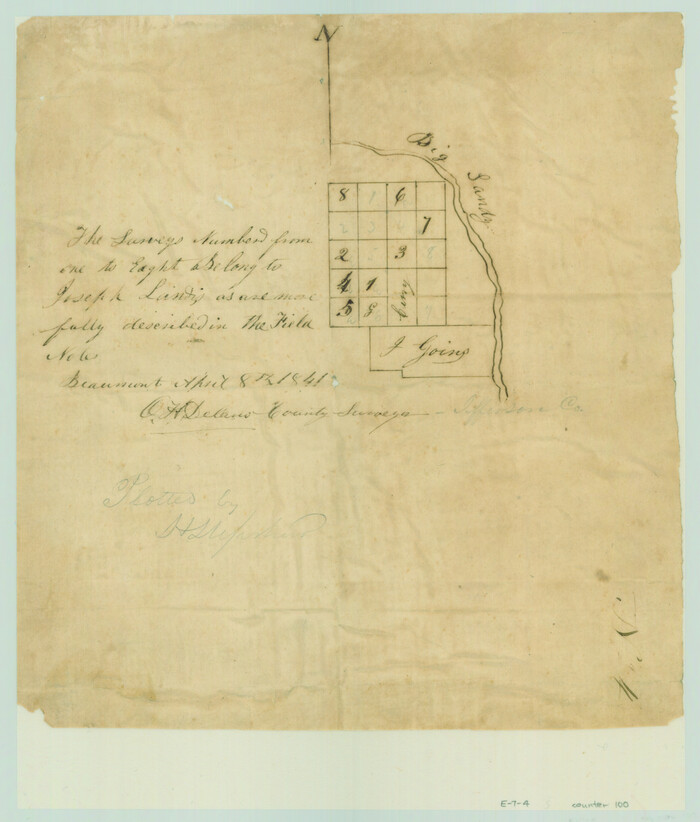
[Surveys in the Jefferson District along Big Sandy Creek]
Print $2.00
- Digital $50.00
[Surveys in the Jefferson District along Big Sandy Creek]
1841
Size: 9.5 x 8.1 inches
100
Liberty County Rolled Sketch N

Print $20.00
- Digital $50.00
Liberty County Rolled Sketch N
Size: 44.7 x 38.5 inches
10180
Liberty County Rolled Sketch N

Print $20.00
- Digital $50.00
Liberty County Rolled Sketch N
Size: 38.4 x 47.9 inches
10181
Hardin County Rolled Sketch 12

Print $20.00
- Digital $50.00
Hardin County Rolled Sketch 12
1949
Size: 36.3 x 47.3 inches
10200
Hardin County Rolled Sketch 19

Print $20.00
- Digital $50.00
Hardin County Rolled Sketch 19
1953
Size: 41.2 x 33.8 inches
10677
Liberty County Rolled Sketch N

Print $20.00
- Digital $50.00
Liberty County Rolled Sketch N
1954
Size: 45.1 x 39.1 inches
10721
Hardin County Sketch File 33

Print $20.00
- Digital $50.00
Hardin County Sketch File 33
Size: 25.4 x 35.4 inches
11632
Hardin County Sketch File 37

Print $20.00
- Digital $50.00
Hardin County Sketch File 37
Size: 20.4 x 17.7 inches
11633
Hardin County Sketch File 48

Print $20.00
- Digital $50.00
Hardin County Sketch File 48
Size: 17.8 x 18.4 inches
11634
Hardin County Sketch File 54

Print $20.00
- Digital $50.00
Hardin County Sketch File 54
1924
Size: 16.6 x 17.9 inches
11635
Hardin County Sketch File 61

Print $20.00
- Digital $50.00
Hardin County Sketch File 61
1933
Size: 18.9 x 24.6 inches
11636
Hardin County Sketch File 62

Print $20.00
- Digital $50.00
Hardin County Sketch File 62
Size: 19.9 x 26.2 inches
11637
Hardin County Sketch File 64

Print $24.00
- Digital $50.00
Hardin County Sketch File 64
1936
Size: 24.5 x 25.6 inches
11638
Hardin County Sketch File 66

Print $20.00
- Digital $50.00
Hardin County Sketch File 66
1948
Size: 19.5 x 35.8 inches
11639
Hardin County Sketch File 68

Print $20.00
- Digital $50.00
Hardin County Sketch File 68
1948
Size: 23.9 x 21.4 inches
11640
Hardin County Sketch File 69

Print $20.00
- Digital $50.00
Hardin County Sketch File 69
1944
Size: 25.1 x 22.0 inches
11641
Hardin County Sketch File 71e

Print $20.00
- Digital $50.00
Hardin County Sketch File 71e
Size: 25.2 x 37.1 inches
11642
Hardin County Sketch File 71f

Print $20.00
- Digital $50.00
Hardin County Sketch File 71f
1997
Size: 25.2 x 36.7 inches
11643
Hardin County Sketch File A

Print $20.00
- Digital $50.00
Hardin County Sketch File A
Size: 19.3 x 33.4 inches
11644
Hardin County Sketch File Q-11

Print $20.00
- Digital $50.00
Hardin County Sketch File Q-11
1937
Size: 19.9 x 23.8 inches
11645
Jefferson County Sketch File 15b

Print $26.00
- Digital $50.00
Jefferson County Sketch File 15b
Size: 17.4 x 33.2 inches
11869
Jefferson County Sketch File 43

Print $20.00
- Digital $50.00
Jefferson County Sketch File 43
1957
Size: 26.6 x 19.6 inches
11877
Polk County Sketch File 18

Print $20.00
- Digital $50.00
Polk County Sketch File 18
1862
Size: 25.5 x 18.9 inches
12190
Polk County Sketch File 23

Print $20.00
- Digital $50.00
Polk County Sketch File 23
Size: 18.0 x 18.6 inches
12191
Tyler County Sketch File 5

Print $20.00
- Digital $50.00
Tyler County Sketch File 5
1854
Size: 13.2 x 17.4 inches
12497
Copy of connection made by E. Sewell

Print $2.00
- Digital $50.00
Copy of connection made by E. Sewell
1841
Size: 9.4 x 9.0 inches
161
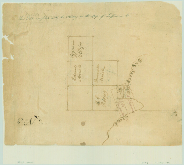
[Sketch of Surveys on Big Sandy Creek]
Print $2.00
- Digital $50.00
[Sketch of Surveys on Big Sandy Creek]
1841
Size: 8.2 x 9.2 inches
179
[Liberty County, Texas]
Print $20.00
- Digital $50.00
[Liberty County, Texas]
1890
Size: 23.7 x 18.3 inches
2058
[Surveys in the Jefferson District along Big Sandy Creek]
Print $2.00
- Digital $50.00
[Surveys in the Jefferson District along Big Sandy Creek]
1841
-
Size
9.5 x 8.1 inches
-
Map/Doc
100
-
Creation Date
1841
Liberty County Rolled Sketch N
Print $20.00
- Digital $50.00
Liberty County Rolled Sketch N
-
Size
44.7 x 38.5 inches
-
Map/Doc
10180
Liberty County Rolled Sketch N
Print $20.00
- Digital $50.00
Liberty County Rolled Sketch N
-
Size
38.4 x 47.9 inches
-
Map/Doc
10181
Hardin County Rolled Sketch 12
Print $20.00
- Digital $50.00
Hardin County Rolled Sketch 12
1949
-
Size
36.3 x 47.3 inches
-
Map/Doc
10200
-
Creation Date
1949
Hardin County Rolled Sketch 19
Print $20.00
- Digital $50.00
Hardin County Rolled Sketch 19
1953
-
Size
41.2 x 33.8 inches
-
Map/Doc
10677
-
Creation Date
1953
Liberty County Rolled Sketch N
Print $20.00
- Digital $50.00
Liberty County Rolled Sketch N
1954
-
Size
45.1 x 39.1 inches
-
Map/Doc
10721
-
Creation Date
1954
Hardin County Sketch File 33
Print $20.00
- Digital $50.00
Hardin County Sketch File 33
-
Size
25.4 x 35.4 inches
-
Map/Doc
11632
Hardin County Sketch File 37
Print $20.00
- Digital $50.00
Hardin County Sketch File 37
-
Size
20.4 x 17.7 inches
-
Map/Doc
11633
Hardin County Sketch File 48
Print $20.00
- Digital $50.00
Hardin County Sketch File 48
-
Size
17.8 x 18.4 inches
-
Map/Doc
11634
Hardin County Sketch File 54
Print $20.00
- Digital $50.00
Hardin County Sketch File 54
1924
-
Size
16.6 x 17.9 inches
-
Map/Doc
11635
-
Creation Date
1924
Hardin County Sketch File 61
Print $20.00
- Digital $50.00
Hardin County Sketch File 61
1933
-
Size
18.9 x 24.6 inches
-
Map/Doc
11636
-
Creation Date
1933
Hardin County Sketch File 62
Print $20.00
- Digital $50.00
Hardin County Sketch File 62
-
Size
19.9 x 26.2 inches
-
Map/Doc
11637
Hardin County Sketch File 64
Print $24.00
- Digital $50.00
Hardin County Sketch File 64
1936
-
Size
24.5 x 25.6 inches
-
Map/Doc
11638
-
Creation Date
1936
Hardin County Sketch File 66
Print $20.00
- Digital $50.00
Hardin County Sketch File 66
1948
-
Size
19.5 x 35.8 inches
-
Map/Doc
11639
-
Creation Date
1948
Hardin County Sketch File 68
Print $20.00
- Digital $50.00
Hardin County Sketch File 68
1948
-
Size
23.9 x 21.4 inches
-
Map/Doc
11640
-
Creation Date
1948
Hardin County Sketch File 69
Print $20.00
- Digital $50.00
Hardin County Sketch File 69
1944
-
Size
25.1 x 22.0 inches
-
Map/Doc
11641
-
Creation Date
1944
Hardin County Sketch File 71e
Print $20.00
- Digital $50.00
Hardin County Sketch File 71e
-
Size
25.2 x 37.1 inches
-
Map/Doc
11642
Hardin County Sketch File 71f
Print $20.00
- Digital $50.00
Hardin County Sketch File 71f
1997
-
Size
25.2 x 36.7 inches
-
Map/Doc
11643
-
Creation Date
1997
Hardin County Sketch File A
Print $20.00
- Digital $50.00
Hardin County Sketch File A
-
Size
19.3 x 33.4 inches
-
Map/Doc
11644
Hardin County Sketch File Q-11
Print $20.00
- Digital $50.00
Hardin County Sketch File Q-11
1937
-
Size
19.9 x 23.8 inches
-
Map/Doc
11645
-
Creation Date
1937
Jefferson County Sketch File 15b
Print $26.00
- Digital $50.00
Jefferson County Sketch File 15b
-
Size
17.4 x 33.2 inches
-
Map/Doc
11869
Jefferson County Sketch File 43
Print $20.00
- Digital $50.00
Jefferson County Sketch File 43
1957
-
Size
26.6 x 19.6 inches
-
Map/Doc
11877
-
Creation Date
1957
Polk County Sketch File 18
Print $20.00
- Digital $50.00
Polk County Sketch File 18
1862
-
Size
25.5 x 18.9 inches
-
Map/Doc
12190
-
Creation Date
1862
Polk County Sketch File 23
Print $20.00
- Digital $50.00
Polk County Sketch File 23
-
Size
18.0 x 18.6 inches
-
Map/Doc
12191
Tyler County Sketch File 5
Print $20.00
- Digital $50.00
Tyler County Sketch File 5
1854
-
Size
13.2 x 17.4 inches
-
Map/Doc
12497
-
Creation Date
1854
Copy of connection made by E. Sewell
Print $2.00
- Digital $50.00
Copy of connection made by E. Sewell
1841
-
Size
9.4 x 9.0 inches
-
Map/Doc
161
-
Creation Date
1841
Hardin County

Print $20.00
- Digital $50.00
Hardin County
1894
-
Size
46.8 x 43.4 inches
-
Map/Doc
16846
-
Creation Date
1894
[Sketch of Surveys on Big Sandy Creek]
Print $2.00
- Digital $50.00
[Sketch of Surveys on Big Sandy Creek]
1841
-
Size
8.2 x 9.2 inches
-
Map/Doc
179
-
Creation Date
1841
Hardin County

Print $20.00
- Digital $50.00
Hardin County
1940
-
Size
47.8 x 43.6 inches
-
Map/Doc
1849
-
Creation Date
1940
[Liberty County, Texas]
Print $20.00
- Digital $50.00
[Liberty County, Texas]
1890
-
Size
23.7 x 18.3 inches
-
Map/Doc
2058
-
Creation Date
1890