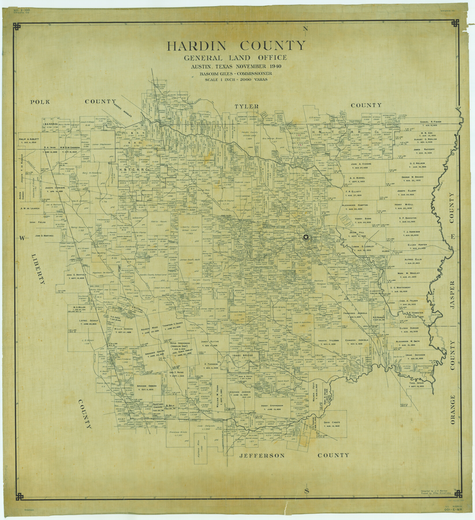
Hardin County
RM-3-100
-
Map/Doc
1849
-
Collection
General Map Collection
-
Object Dates
1940 (Creation Date)
-
People and Organizations
Texas General Land Office (Publisher)
Bascom Giles (GLO Commissioner)
J.O. Barrow (Compiler)
-
Counties
Hardin
-
Subjects
County
-
Height x Width
47.8 x 43.6 inches
121.4 x 110.7 cm
-
Comments
Traced by Eltea Armstrong.
Part of: General Map Collection
Travis County Working Sketch 60

Print $20.00
- Digital $50.00
Travis County Working Sketch 60
1992
Size 21.8 x 20.9 inches
Map/Doc 69444
Blanco County Sketch File 18

Print $4.00
- Digital $50.00
Blanco County Sketch File 18
1877
Size 12.6 x 8.5 inches
Map/Doc 14594

Galveston County Rolled Sketch JS

Print $20.00
- Digital $50.00
Galveston County Rolled Sketch JS
1934
Size 34.0 x 41.9 inches
Map/Doc 9091
Flight Mission No. BQR-7K, Frame 28, Brazoria County

Print $20.00
- Digital $50.00
Flight Mission No. BQR-7K, Frame 28, Brazoria County
1952
Size 18.5 x 22.2 inches
Map/Doc 84026
Kimble County Sketch File 14

Print $26.00
- Digital $50.00
Kimble County Sketch File 14
1886
Size 14.1 x 8.6 inches
Map/Doc 28939
Shelby County Rolled Sketch 10

Print $20.00
- Digital $50.00
Shelby County Rolled Sketch 10
Size 16.2 x 27.3 inches
Map/Doc 7778
Somervell County

Print $20.00
- Digital $50.00
Somervell County
1884
Size 29.5 x 31.3 inches
Map/Doc 63041
Harris County Historic Topographic 8

Print $20.00
- Digital $50.00
Harris County Historic Topographic 8
1916
Size 29.8 x 23.1 inches
Map/Doc 65818
[Map of Matagorda County]
![3841, [Map of Matagorda County], General Map Collection](https://historictexasmaps.com/wmedia_w700/maps/3841-1.tif.jpg)
Print $20.00
- Digital $50.00
[Map of Matagorda County]
Size 24.4 x 25.6 inches
Map/Doc 3841

Flight Mission No. CRC-2R, Frame 63, Chambers County

Print $20.00
- Digital $50.00
Flight Mission No. CRC-2R, Frame 63, Chambers County
1956
Size 18.8 x 22.4 inches
Map/Doc 84734
You may also like
Palo Pinto County Sketch File 25a

Print $6.00
- Digital $50.00
Palo Pinto County Sketch File 25a
Size 11.0 x 11.4 inches
Map/Doc 33417
Hudspeth County Working Sketch 35

Print $40.00
- Digital $50.00
Hudspeth County Working Sketch 35
Size 37.0 x 55.2 inches
Map/Doc 66320
Newton County Aerial Photograph Index Sheet 2

Print $20.00
- Digital $50.00
Newton County Aerial Photograph Index Sheet 2
1953
Size 23.8 x 16.7 inches
Map/Doc 83731
Tarrant County Working Sketch 16

Print $20.00
- Digital $50.00
Tarrant County Working Sketch 16
1991
Size 14.5 x 23.9 inches
Map/Doc 62433
Webb County Working Sketch 22

Print $20.00
- Digital $50.00
Webb County Working Sketch 22
1926
Size 22.7 x 20.8 inches
Map/Doc 72387
McMullen County Rolled Sketch 6

Print $20.00
- Digital $50.00
McMullen County Rolled Sketch 6
Size 32.1 x 27.0 inches
Map/Doc 6724
The North Part of America Conteyning Newfoundland, New England, Virginia, Florida, New Spaine, and Nova Francia

Print $20.00
- Digital $50.00
The North Part of America Conteyning Newfoundland, New England, Virginia, Florida, New Spaine, and Nova Francia
1625
Size 12.6 x 16.2 inches
Map/Doc 97028
Mitchell County Sketch File 3

Print $4.00
- Digital $50.00
Mitchell County Sketch File 3
1902
Size 9.2 x 8.4 inches
Map/Doc 31690
Map of Bexar County Showing Subdivisions of Original Surveys and Names of Present Owners

Print $20.00
Map of Bexar County Showing Subdivisions of Original Surveys and Names of Present Owners
1897
Size 46.2 x 41.3 inches
Map/Doc 88908
Eastland County Rolled Sketch 3

Print $20.00
- Digital $50.00
Eastland County Rolled Sketch 3
1893
Size 24.4 x 41.3 inches
Map/Doc 5773
Dickens County Working Sketch Graphic Index

Print $20.00
- Digital $50.00
Dickens County Working Sketch Graphic Index
1963
Size 42.5 x 33.6 inches
Map/Doc 76523
Flight Mission No. BRE-1P, Frame 47, Nueces County

Print $20.00
- Digital $50.00
Flight Mission No. BRE-1P, Frame 47, Nueces County
1956
Size 18.4 x 22.3 inches
Map/Doc 86636