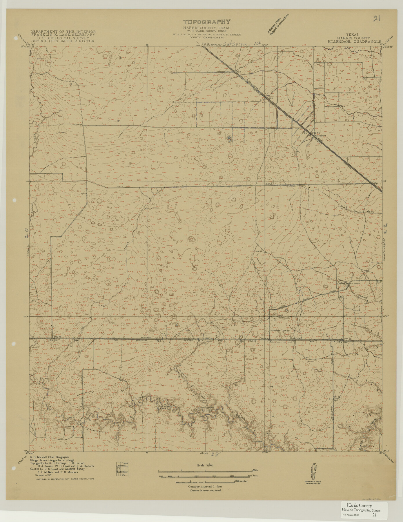
Harris County Historic Topographic 21
Hillendahl Quadrangle
-
Map/Doc
65832
-
Collection
General Map Collection
-
Object Dates
1915 (Creation Date)
-
People and Organizations
U. S. Geological Survey (Publisher)
-
Counties
Harris
-
Subjects
Topographic
-
Height x Width
29.2 x 22.5 inches
74.2 x 57.2 cm
Part of: General Map Collection
Schleicher County Sketch File 36

Print $20.00
- Digital $50.00
Schleicher County Sketch File 36
1951
Size 15.2 x 21.7 inches
Map/Doc 12309
Navigation Maps of Gulf Intracoastal Waterway, Port Arthur to Brownsville, Texas

Print $4.00
- Digital $50.00
Navigation Maps of Gulf Intracoastal Waterway, Port Arthur to Brownsville, Texas
1951
Size 16.7 x 21.5 inches
Map/Doc 65442
Post Route Map of Texas (Inset 1: Dallas-Fort Worth Area; Inset 2: Texas Panhandle)

Print $40.00
- Digital $50.00
Post Route Map of Texas (Inset 1: Dallas-Fort Worth Area; Inset 2: Texas Panhandle)
1939
Size 56.8 x 39.2 inches
Map/Doc 93699
Flight Mission No. DAG-17K, Frame 121, Matagorda County

Print $20.00
- Digital $50.00
Flight Mission No. DAG-17K, Frame 121, Matagorda County
1952
Size 16.4 x 16.5 inches
Map/Doc 86341
Garza County Working Sketch 11

Print $3.00
- Digital $50.00
Garza County Working Sketch 11
1955
Size 14.5 x 10.9 inches
Map/Doc 63158
Runnels County Sketch File 5

Print $22.00
Runnels County Sketch File 5
Size 12.8 x 16.0 inches
Map/Doc 35436
Presidio County Working Sketch 83

Print $20.00
- Digital $50.00
Presidio County Working Sketch 83
1969
Size 21.5 x 24.8 inches
Map/Doc 71760
Jasper County Rolled Sketch 8

Print $20.00
- Digital $50.00
Jasper County Rolled Sketch 8
Size 17.8 x 12.0 inches
Map/Doc 6358
Brazoria County Rolled Sketch 42

Print $20.00
- Digital $50.00
Brazoria County Rolled Sketch 42
1962
Size 35.0 x 44.5 inches
Map/Doc 8461
Runnels County Rolled Sketch 39

Print $20.00
- Digital $50.00
Runnels County Rolled Sketch 39
Size 34.3 x 31.6 inches
Map/Doc 7526
Brazoria County Sketch File 46

Print $48.00
- Digital $50.00
Brazoria County Sketch File 46
1925
Size 14.3 x 8.8 inches
Map/Doc 15082
Burleson County Sketch File 7

Print $40.00
- Digital $50.00
Burleson County Sketch File 7
1935
Size 17.0 x 14.5 inches
Map/Doc 16653
You may also like
Ector County Working Sketch 23

Print $40.00
- Digital $50.00
Ector County Working Sketch 23
1961
Size 55.9 x 43.3 inches
Map/Doc 68866
Edwards County Rolled Sketch 15

Print $20.00
- Digital $50.00
Edwards County Rolled Sketch 15
1893
Size 35.5 x 26.4 inches
Map/Doc 5803
Ector County Working Sketch 19

Print $40.00
- Digital $50.00
Ector County Working Sketch 19
1958
Size 65.8 x 37.6 inches
Map/Doc 68862
Runnels County Sketch File 23

Print $20.00
Runnels County Sketch File 23
1924
Size 21.2 x 19.9 inches
Map/Doc 12257
English Field Notes of the Spanish Archives - Book D

English Field Notes of the Spanish Archives - Book D
1835
Map/Doc 96542
San Patricio County Rolled Sketch 47A

Print $20.00
- Digital $50.00
San Patricio County Rolled Sketch 47A
1939
Size 27.7 x 28.5 inches
Map/Doc 7732
Dawson County Rolled Sketch 10

Print $20.00
- Digital $50.00
Dawson County Rolled Sketch 10
1954
Size 44.5 x 37.9 inches
Map/Doc 8774
Foard County Working Sketch 4

Print $20.00
- Digital $50.00
Foard County Working Sketch 4
1934
Size 29.4 x 27.8 inches
Map/Doc 69194
Hutchinson County Rolled Sketch 18

Print $20.00
- Digital $50.00
Hutchinson County Rolled Sketch 18
Size 30.4 x 32.6 inches
Map/Doc 9244
Lampasas County Boundary File 2a

Print $8.00
- Digital $50.00
Lampasas County Boundary File 2a
Size 14.3 x 8.6 inches
Map/Doc 56097
Kendall County

Print $20.00
- Digital $50.00
Kendall County
1946
Size 41.6 x 35.9 inches
Map/Doc 1872
Current Miscellaneous File 23

Print $4.00
- Digital $50.00
Current Miscellaneous File 23
1953
Size 14.1 x 5.5 inches
Map/Doc 73881