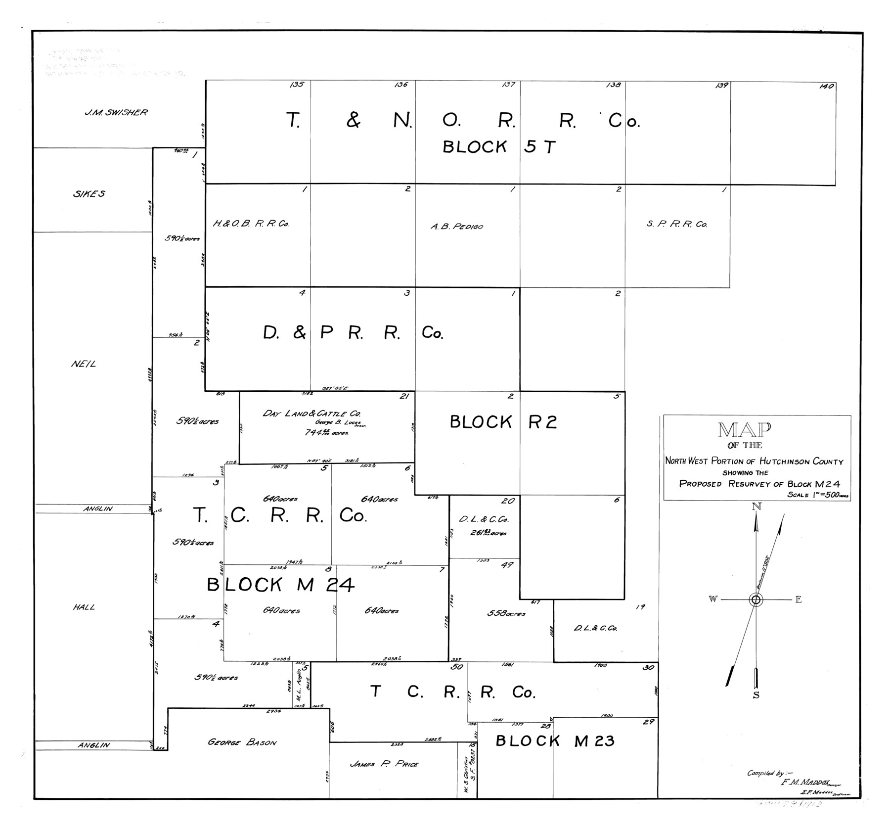
Hutchinson County Rolled Sketch 18
Map of the northwest portion of Hutchinson County showing the proposed resurvey of Block M24
-
Map/Doc
9244
-
Collection
General Map Collection
-
Object Dates
1913/6/28 (File Date)
-
People and Organizations
F.M. Maddox (Compiler)
E.F. Maddox (Draftsman)
-
Counties
Hutchinson
-
Subjects
Surveying Rolled Sketch
-
Height x Width
30.4 x 32.6 inches
77.2 x 82.8 cm
-
Scale
1" = 500 varas
Part of: General Map Collection
Travis County Boundary File 28

Print $8.00
- Digital $50.00
Travis County Boundary File 28
Size 14.7 x 9.0 inches
Map/Doc 59464
Flight Mission No. CRC-3R, Frame 19, Chambers County

Print $20.00
- Digital $50.00
Flight Mission No. CRC-3R, Frame 19, Chambers County
1956
Size 18.5 x 22.1 inches
Map/Doc 84793
Callahan County Sketch File 11

Print $64.00
- Digital $50.00
Callahan County Sketch File 11
Size 11.4 x 8.4 inches
Map/Doc 35887
Calhoun County Rolled Sketch 12

Print $40.00
- Digital $50.00
Calhoun County Rolled Sketch 12
1940
Size 30.2 x 54.8 inches
Map/Doc 43619
Dallas County Working Sketch 5

Print $20.00
- Digital $50.00
Dallas County Working Sketch 5
1941
Size 18.7 x 16.4 inches
Map/Doc 68571
Map of Red River Division of the International & Great Northern Railroad

Print $40.00
- Digital $50.00
Map of Red River Division of the International & Great Northern Railroad
Size 24.1 x 107.0 inches
Map/Doc 64476
Topographical Map of the Rio Grande, Sheet No. 29

Print $20.00
- Digital $50.00
Topographical Map of the Rio Grande, Sheet No. 29
1912
Map/Doc 89553
Right of Way and Track Map, Dayton-Goose Creek Ry. Co., Station 0+00 to Station 190+00

Print $40.00
- Digital $50.00
Right of Way and Track Map, Dayton-Goose Creek Ry. Co., Station 0+00 to Station 190+00
1917
Size 24.8 x 56.6 inches
Map/Doc 64365
A General Map of the Northern British Colonies in America which comprehends the Province of Quebec, the Government of Newfoundland, Nova-Scotia, New England and New York

Print $20.00
- Digital $50.00
A General Map of the Northern British Colonies in America which comprehends the Province of Quebec, the Government of Newfoundland, Nova-Scotia, New England and New York
1776
Size 21.3 x 27.3 inches
Map/Doc 97401
Texas Gulf Coast Bay Index Map

Print $20.00
- Digital $50.00
Texas Gulf Coast Bay Index Map
Size 43.7 x 42.6 inches
Map/Doc 73599
Anderson County Sketch File 16

Print $6.00
- Digital $50.00
Anderson County Sketch File 16
1849
Size 8.6 x 6.5 inches
Map/Doc 12783
Swisher County Sketch File 5

Print $8.00
- Digital $50.00
Swisher County Sketch File 5
1876
Size 14.3 x 8.8 inches
Map/Doc 37618
You may also like
J. De Cordova's Map of the State of Texas Compiled from the records of the General Land Office of the State

Print $20.00
- Digital $50.00
J. De Cordova's Map of the State of Texas Compiled from the records of the General Land Office of the State
1854
Size 25.6 x 23.4 inches
Map/Doc 93903
General Land Office and State Reclamation Department - An Index Map

Print $20.00
- Digital $50.00
General Land Office and State Reclamation Department - An Index Map
1930
Size 26.2 x 16.6 inches
Map/Doc 65069
Flight Mission No. DCL-7C, Frame 3, Kenedy County

Print $20.00
- Digital $50.00
Flight Mission No. DCL-7C, Frame 3, Kenedy County
1943
Size 18.5 x 22.3 inches
Map/Doc 85995

Presidio County Working Sketch Graphic Index, South Part, Sheet 1 (Sketches 1 to 44)

Print $20.00
- Digital $50.00
Presidio County Working Sketch Graphic Index, South Part, Sheet 1 (Sketches 1 to 44)
1975
Size 32.3 x 38.0 inches
Map/Doc 76670
Concho County Working Sketch 3

Print $20.00
- Digital $50.00
Concho County Working Sketch 3
1918
Size 24.0 x 22.2 inches
Map/Doc 68185
[Right of Way & Track Map, The Texas & Pacific Ry. Co. Main Line]
![64674, [Right of Way & Track Map, The Texas & Pacific Ry. Co. Main Line], General Map Collection](https://historictexasmaps.com/wmedia_w700/maps/64674.tif.jpg)
Print $20.00
- Digital $50.00
[Right of Way & Track Map, The Texas & Pacific Ry. Co. Main Line]
Size 11.1 x 18.6 inches
Map/Doc 64674
Briscoe County Rolled Sketch WL

Print $20.00
- Digital $50.00
Briscoe County Rolled Sketch WL
1936
Size 18.6 x 43.0 inches
Map/Doc 5335
McLennan County Sketch File 41

Print $44.00
- Digital $50.00
McLennan County Sketch File 41
1963
Size 11.1 x 8.6 inches
Map/Doc 31319
Terry County Working Sketch 2

Print $20.00
- Digital $50.00
Terry County Working Sketch 2
1952
Size 19.3 x 19.3 inches
Map/Doc 62107
Jasper County Sketch File 12

Print $4.00
- Digital $50.00
Jasper County Sketch File 12
Size 8.8 x 10.0 inches
Map/Doc 27792
Erath County Working Sketch 4

Print $20.00
- Digital $50.00
Erath County Working Sketch 4
1919
Size 31.7 x 28.6 inches
Map/Doc 69085