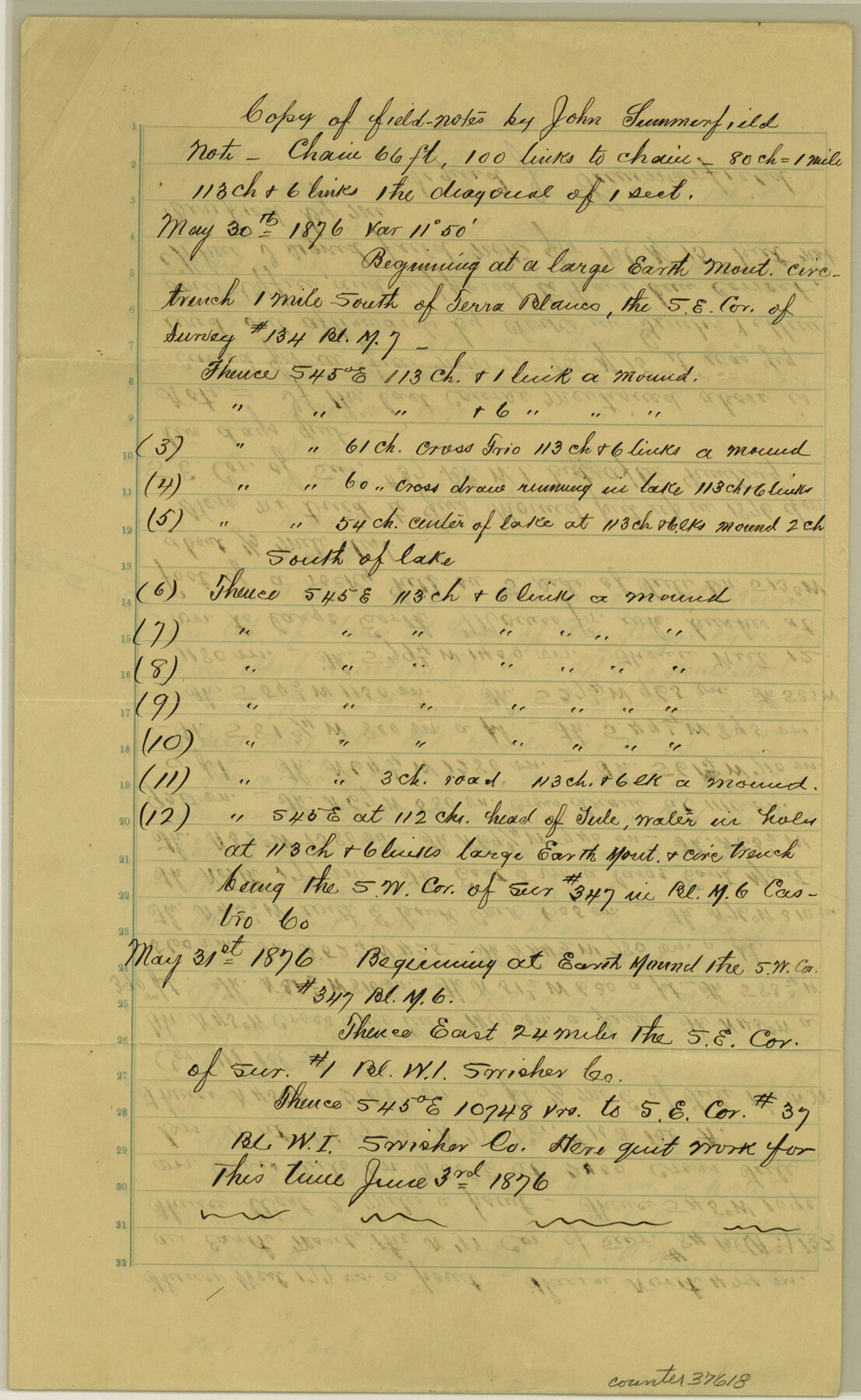
Swisher County Sketch File 5
[Copy of field notes of connections in Swisher and Briscoe Counties]
-
Map/Doc
37618
-
Collection
General Map Collection
-
Object Dates
1876 (Creation Date)
1879 (Creation Date)
-
People and Organizations
John Summerfield (Surveyor/Engineer)
-
Counties
Swisher Briscoe
-
Subjects
Surveying Sketch File
-
Height x Width
14.3 x 8.8 inches
36.3 x 22.4 cm
-
Medium
paper, manuscript
-
Features
Queteka Peak
Los Lingos Creek
Spring Branch
Tule Creek
McKenzie Trail
Part of: General Map Collection
Leon County Rolled Sketch 9

Print $40.00
- Digital $50.00
Leon County Rolled Sketch 9
1960
Size 50.1 x 35.2 inches
Map/Doc 9430
Flight Mission No. DAG-26K, Frame 58, Matagorda County

Print $20.00
- Digital $50.00
Flight Mission No. DAG-26K, Frame 58, Matagorda County
1953
Size 18.5 x 16.1 inches
Map/Doc 86578
Kendall County Working Sketch Graphic Index

Print $20.00
- Digital $50.00
Kendall County Working Sketch Graphic Index
1946
Size 40.3 x 34.8 inches
Map/Doc 76602
Oldham County Working Sketch 3

Print $20.00
- Digital $50.00
Oldham County Working Sketch 3
1946
Size 26.2 x 19.3 inches
Map/Doc 71325
Val Verde Co.

Print $20.00
- Digital $50.00
Val Verde Co.
1908
Size 42.4 x 38.7 inches
Map/Doc 16912
El Paso County Boundary File 27

Print $2.00
- Digital $50.00
El Paso County Boundary File 27
Size 7.3 x 5.6 inches
Map/Doc 53236
Flight Mission No. DQO-2K, Frame 134, Galveston County

Print $20.00
- Digital $50.00
Flight Mission No. DQO-2K, Frame 134, Galveston County
1952
Size 18.7 x 22.4 inches
Map/Doc 85031

[F. W. & D. C. Ry. Co. Alignment and Right of Way Map, Clay County]
![64732, [F. W. & D. C. Ry. Co. Alignment and Right of Way Map, Clay County], General Map Collection](https://historictexasmaps.com/wmedia_w700/maps/64732-GC.tif.jpg)
Print $20.00
- Digital $50.00
[F. W. & D. C. Ry. Co. Alignment and Right of Way Map, Clay County]
1927
Size 18.6 x 11.8 inches
Map/Doc 64732
Brazoria County Rolled Sketch CL

Print $20.00
- Digital $50.00
Brazoria County Rolled Sketch CL
1934
Size 22.0 x 32.8 inches
Map/Doc 8463
Hutchinson County Rolled Sketch 44-9

Print $20.00
- Digital $50.00
Hutchinson County Rolled Sketch 44-9
2002
Size 24.0 x 36.0 inches
Map/Doc 77545
La Salle County Sketch File 48

Print $6.00
- Digital $50.00
La Salle County Sketch File 48
1942
Size 11.2 x 8.8 inches
Map/Doc 29617
You may also like
Crockett County Sketch File 96

Print $4.00
- Digital $50.00
Crockett County Sketch File 96
1934
Size 11.4 x 8.9 inches
Map/Doc 19964
Refugio County Working Sketch 1

Print $20.00
- Digital $50.00
Refugio County Working Sketch 1
1917
Size 18.8 x 18.0 inches
Map/Doc 63510
Goliad County Sketch File 36

Print $20.00
- Digital $50.00
Goliad County Sketch File 36
1925
Size 17.1 x 14.1 inches
Map/Doc 11571
Travis County Sketch File 77

Print $26.00
- Digital $50.00
Travis County Sketch File 77
2004
Size 11.0 x 8.5 inches
Map/Doc 83254
Anderson County Boundary File 2

Print $8.00
- Digital $50.00
Anderson County Boundary File 2
Size 14.3 x 8.7 inches
Map/Doc 49730
Deaf Smith County

Print $20.00
- Digital $50.00
Deaf Smith County
1926
Size 32.9 x 41.3 inches
Map/Doc 77260
Kendall County Sketch File 20

Print $42.00
- Digital $50.00
Kendall County Sketch File 20
1916
Size 9.7 x 6.3 inches
Map/Doc 28713
Trinity County Sketch File 28

Print $22.00
- Digital $50.00
Trinity County Sketch File 28
Size 7.0 x 19.7 inches
Map/Doc 38564
Motley County Sketch File 5 (N)

Print $8.00
- Digital $50.00
Motley County Sketch File 5 (N)
Size 12.6 x 8.3 inches
Map/Doc 32000
Traced from Genl. Arista's map captured by the American Army under Genl. Taylor at Resaca de la Palma 9th May '46 and presented to James K. Polk, President U. States

Print $20.00
- Digital $50.00
Traced from Genl. Arista's map captured by the American Army under Genl. Taylor at Resaca de la Palma 9th May '46 and presented to James K. Polk, President U. States
1846
Size 18.1 x 27.3 inches
Map/Doc 73062
Hockley County

Print $20.00
- Digital $50.00
Hockley County
1914
Size 25.8 x 22.4 inches
Map/Doc 66866
Anderson County Sketch File 6a

Print $4.00
- Digital $50.00
Anderson County Sketch File 6a
1848
Size 12.6 x 7.5 inches
Map/Doc 12755