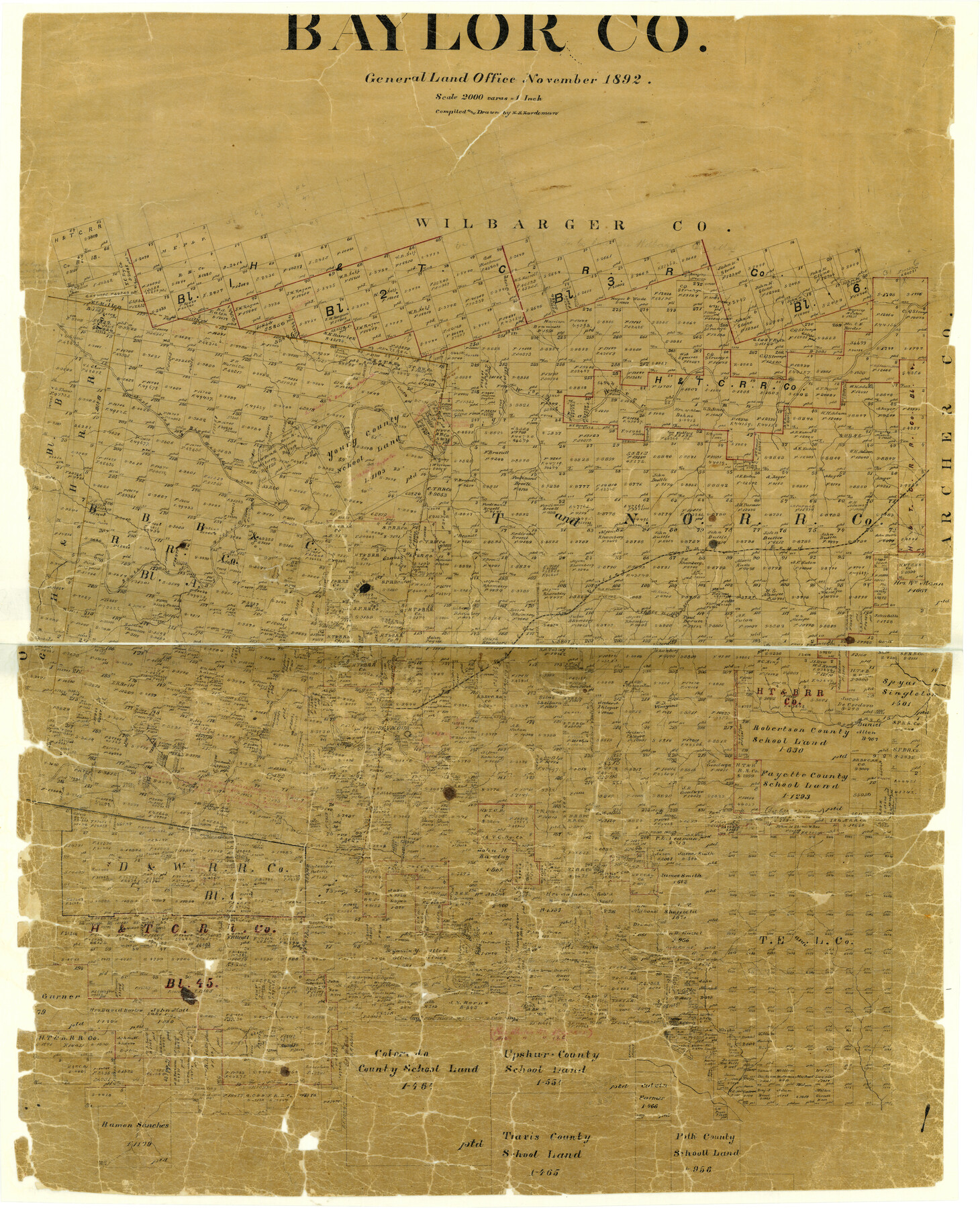
Baylor Co.
-
Map/Doc
3285
-
Collection
General Map Collection
-
Object Dates
11/1892 (Creation Date)
-
People and Organizations
Texas General Land Office (Publisher)
H.B. Hardeman (Compiler)
H.B. Hardeman (Draftsman)
-
Counties
Baylor
-
Subjects
County
-
Height x Width
41.8 x 36.0 inches
106.2 x 91.4 cm
-
Comments
Help Save Texas History - Adopt Me!
-
Features
Herberts Creek
North Fork of Big Wichita River
Big Wichita River
Brushy Creek
South Fork of Wichita River
WVRR
Little Wichita River
Goodwins Creek
Rock Creek
Seymour
Brazos River
Lake Creek
Gray Creek
Cole Creek
Deer Creek
Mexican Creek
Part of: General Map Collection
Texas Gulf Coast, from the Sabine River to the Rio Grande as Subdivided for Mineral Development; Aransas, Nueces, Kleberg, Kenedy, Willacy, and Cameron Counties

Print $40.00
- Digital $50.00
Texas Gulf Coast, from the Sabine River to the Rio Grande as Subdivided for Mineral Development; Aransas, Nueces, Kleberg, Kenedy, Willacy, and Cameron Counties
1976
Size 118.0 x 43.0 inches
Map/Doc 1940
Outer Continental Shelf Leasing Maps (Texas Offshore Operations)

Print $20.00
- Digital $50.00
Outer Continental Shelf Leasing Maps (Texas Offshore Operations)
Size 19.4 x 18.5 inches
Map/Doc 75849
Shelby County Working Sketch 17

Print $20.00
- Digital $50.00
Shelby County Working Sketch 17
1957
Size 20.4 x 31.0 inches
Map/Doc 63870
Travis County Sketch File 9

Print $4.00
- Digital $50.00
Travis County Sketch File 9
Size 12.6 x 8.2 inches
Map/Doc 38290
Matagorda Bay and Approaches

Print $20.00
- Digital $50.00
Matagorda Bay and Approaches
1992
Size 36.6 x 44.6 inches
Map/Doc 73390
Houston Ship Channel, Atkinson Island to Alexander Island

Print $40.00
- Digital $50.00
Houston Ship Channel, Atkinson Island to Alexander Island
1975
Size 36.2 x 50.4 inches
Map/Doc 69903
Culberson County Rolled Sketch 54

Print $40.00
- Digital $50.00
Culberson County Rolled Sketch 54
1968
Size 59.0 x 29.4 inches
Map/Doc 10300
Brazoria County Sketch File 18

Print $18.00
- Digital $50.00
Brazoria County Sketch File 18
Size 14.5 x 8.9 inches
Map/Doc 14989
Karnes County

Print $20.00
- Digital $50.00
Karnes County
1921
Size 44.3 x 39.6 inches
Map/Doc 95551
Kent County Sketch File 11

Print $22.00
- Digital $50.00
Kent County Sketch File 11
1915
Size 7.9 x 8.6 inches
Map/Doc 28838
Tyler County Sketch File 27

Print $6.00
- Digital $50.00
Tyler County Sketch File 27
1956
Size 14.5 x 8.8 inches
Map/Doc 38696

You may also like
Right of Way and Track Map, Houston & Texas Central R.R. operated by the T. and N. O. R.R., Fort Worth Branch

Print $40.00
- Digital $50.00
Right of Way and Track Map, Houston & Texas Central R.R. operated by the T. and N. O. R.R., Fort Worth Branch
1918
Size 30.9 x 56.9 inches
Map/Doc 64783
[St. L. S-W. Ry. of Texas Map of Lufkin Branch in Cherokee County Texas]
![64018, [St. L. S-W. Ry. of Texas Map of Lufkin Branch in Cherokee County Texas], General Map Collection](https://historictexasmaps.com/wmedia_w700/maps/64018.tif.jpg)
Print $40.00
- Digital $50.00
[St. L. S-W. Ry. of Texas Map of Lufkin Branch in Cherokee County Texas]
1912
Size 22.3 x 121.1 inches
Map/Doc 64018
Amistad International Reservoir on Rio Grande 78a

Print $20.00
- Digital $50.00
Amistad International Reservoir on Rio Grande 78a
1949
Size 28.5 x 40.1 inches
Map/Doc 75507
Map of the Recognised Line, M. El. P. & P. RR. from Texas & Arkansas State Line to Milam & Bexar Land District Line

Print $40.00
- Digital $50.00
Map of the Recognised Line, M. El. P. & P. RR. from Texas & Arkansas State Line to Milam & Bexar Land District Line
Size 15.3 x 89.4 inches
Map/Doc 64638
[Warren Additions 3 and 4 and vicinity]
![92464, [Warren Additions 3 and 4 and vicinity], Twichell Survey Records](https://historictexasmaps.com/wmedia_w700/maps/92464-1.tif.jpg)
Print $20.00
- Digital $50.00
[Warren Additions 3 and 4 and vicinity]
Size 23.9 x 19.5 inches
Map/Doc 92464
Map of the Lands Surveyed by the Memphis, El Paso & Pacific R.R. Company

Print $20.00
- Digital $50.00
Map of the Lands Surveyed by the Memphis, El Paso & Pacific R.R. Company
1860
Size 17.7 x 21.7 inches
Map/Doc 4851
Angelina County Sketch File 4

Print $4.00
- Digital $50.00
Angelina County Sketch File 4
1854
Size 8.3 x 9.0 inches
Map/Doc 12926
Mills County Boundary File 1a

Print $60.00
- Digital $50.00
Mills County Boundary File 1a
Size 9.7 x 31.6 inches
Map/Doc 57273
Hays County Sketch File 18

Print $4.00
- Digital $50.00
Hays County Sketch File 18
1878
Size 13.0 x 8.1 inches
Map/Doc 26235
SW/4 of County, B.S.& F. Bk. M-10, J.W.Woodburn Bk.B-1 & G.C.&S.F. Bk.BIGN

Print $20.00
- Digital $50.00
SW/4 of County, B.S.& F. Bk. M-10, J.W.Woodburn Bk.B-1 & G.C.&S.F. Bk.BIGN
Size 34.6 x 27.0 inches
Map/Doc 90266
Terrell County

Print $20.00
- Digital $50.00
Terrell County
1905
Size 41.6 x 30.9 inches
Map/Doc 63061
