Tyler County Sketch File 27
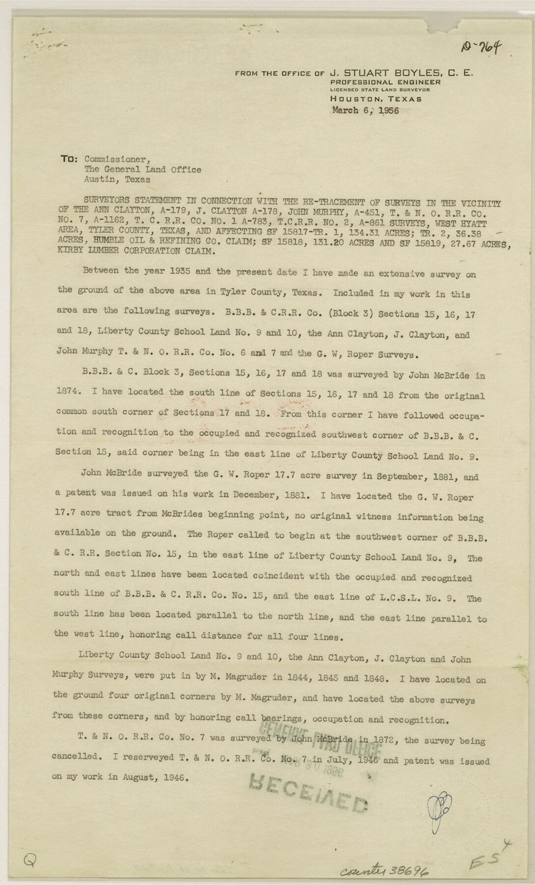
[Surveyor's statement in connection with the retracement of surveys affecting SF-15817, SF-15818, and SF-15819 in the south part of the county]
-
Map/Doc
38696
-
Collection
General Map Collection
-
Object Dates
3/6/1956 (Creation Date)
3/20/1956 (File Date)
-
People and Organizations
J.S. Boyles (Surveyor/Engineer)
-
Counties
Tyler
-
Subjects
Surveying Sketch File
-
Height x Width
14.5 x 8.8 inches
36.8 x 22.4 cm
-
Medium
paper, print
-
Comments
See Tyler County Rolled Sketch 6 (10029) for sketch.
Related maps
Tyler County Rolled Sketch 6

Print $40.00
- Digital $50.00
Tyler County Rolled Sketch 6
1956
Size 76.1 x 43.2 inches
Map/Doc 10029
Part of: General Map Collection
Dimmit County Sketch File 14

Print $20.00
- Digital $50.00
Dimmit County Sketch File 14
1884
Size 35.7 x 23.3 inches
Map/Doc 11342
Polk County Rolled Sketch TS

Print $40.00
- Digital $50.00
Polk County Rolled Sketch TS
1937
Size 37.9 x 58.9 inches
Map/Doc 9755
Titus County Sketch File 14

Print $4.00
- Digital $50.00
Titus County Sketch File 14
Size 9.7 x 8.3 inches
Map/Doc 38157
Gulf Coast of the United States, Key West to Rio Grande

Print $20.00
- Digital $50.00
Gulf Coast of the United States, Key West to Rio Grande
1863
Size 18.3 x 27.2 inches
Map/Doc 72667
Matagorda County Working Sketch 22

Print $20.00
- Digital $50.00
Matagorda County Working Sketch 22
1967
Size 30.0 x 38.8 inches
Map/Doc 70880
Amistad International Reservoir on Rio Grande 73

Print $20.00
- Digital $50.00
Amistad International Reservoir on Rio Grande 73
1949
Size 28.5 x 40.1 inches
Map/Doc 73362
Hill County Sketch File 10

Print $4.00
- Digital $50.00
Hill County Sketch File 10
1859
Size 7.1 x 8.2 inches
Map/Doc 26478
Live Oak County Working Sketch 16

Print $20.00
- Digital $50.00
Live Oak County Working Sketch 16
1954
Size 22.2 x 21.8 inches
Map/Doc 70601
Corrected Map of T&P Ry. surveys in counties Pecos-Presidio-El Paso

Print $20.00
- Digital $50.00
Corrected Map of T&P Ry. surveys in counties Pecos-Presidio-El Paso
1884
Size 27.9 x 39.0 inches
Map/Doc 2301
Flight Mission No. DAG-21K, Frame 133, Matagorda County

Print $20.00
- Digital $50.00
Flight Mission No. DAG-21K, Frame 133, Matagorda County
1952
Size 18.6 x 22.4 inches
Map/Doc 86459
Cameron County Aerial Photograph Index Sheet 5

Print $20.00
- Digital $50.00
Cameron County Aerial Photograph Index Sheet 5
1940
Size 20.4 x 24.3 inches
Map/Doc 83681
Milam County Sketch File 5

Print $4.00
- Digital $50.00
Milam County Sketch File 5
1901
Size 14.2 x 8.7 inches
Map/Doc 31632
You may also like

Marion County

Print $20.00
- Digital $50.00
Marion County
1943
Size 24.3 x 41.2 inches
Map/Doc 77365
Brazoria County Sketch File 28

Print $6.00
- Digital $50.00
Brazoria County Sketch File 28
1889
Size 8.8 x 14.2 inches
Map/Doc 15030
Brewster County Working Sketch 111

Print $40.00
- Digital $50.00
Brewster County Working Sketch 111
1982
Size 21.5 x 55.9 inches
Map/Doc 67711
Township 6 North Range 13 West, North Western District, Louisiana

Print $20.00
- Digital $50.00
Township 6 North Range 13 West, North Western District, Louisiana
1841
Size 19.7 x 24.8 inches
Map/Doc 65864
Cherokee County Working Sketch 21

Print $40.00
- Digital $50.00
Cherokee County Working Sketch 21
1969
Size 37.6 x 57.0 inches
Map/Doc 67976

Flight Mission No. BQR-5K, Frame 73, Brazoria County

Print $20.00
- Digital $50.00
Flight Mission No. BQR-5K, Frame 73, Brazoria County
1952
Size 19.1 x 22.6 inches
Map/Doc 84018
Young County Sketch File 10

Print $20.00
- Digital $50.00
Young County Sketch File 10
Size 14.1 x 17.7 inches
Map/Doc 12711
Padre Island National Seashore, Texas - Dependent Resurvey

Print $4.00
- Digital $50.00
Padre Island National Seashore, Texas - Dependent Resurvey
2001
Size 18.4 x 24.0 inches
Map/Doc 60551
Galveston County Sketch File 5a

Print $4.00
- Digital $50.00
Galveston County Sketch File 5a
1847
Size 12.6 x 8.2 inches
Map/Doc 23360
Williamson County Sketch File 23

Print $4.00
- Digital $50.00
Williamson County Sketch File 23
1877
Size 12.8 x 8.1 inches
Map/Doc 40353