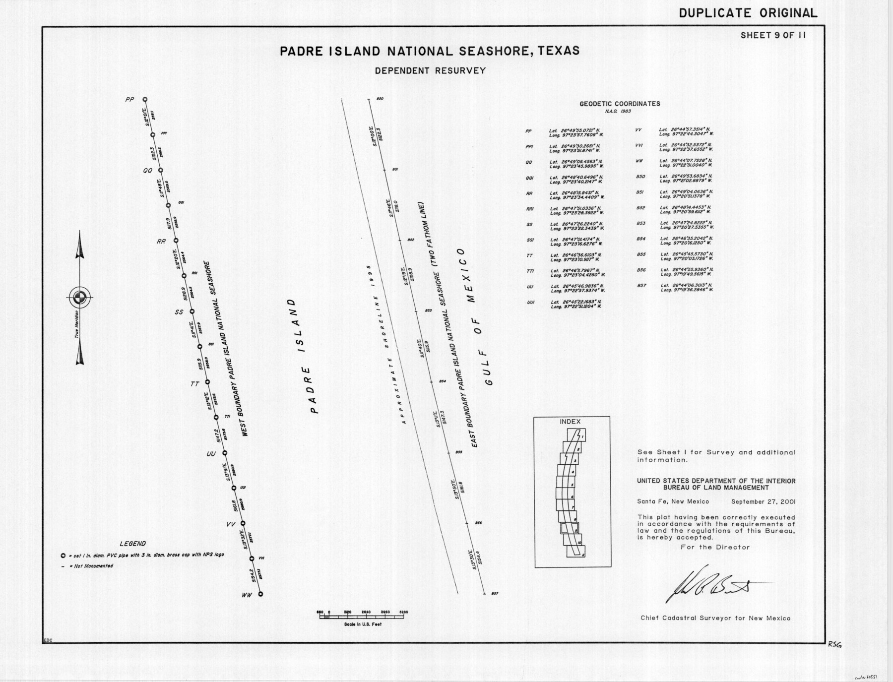
Padre Island National Seashore, Texas - Dependent Resurvey
-
Map/Doc
60551
-
Collection
General Map Collection
-
Object Dates
2001 (Creation Date)
-
Height x Width
18.4 x 24.0 inches
46.7 x 61.0 cm
Part of: General Map Collection
[Maps of surveys in Reeves & Culberson Cos]
![61129, [Maps of surveys in Reeves & Culberson Cos], General Map Collection](https://historictexasmaps.com/wmedia_w700/maps/61129.tif.jpg)
Print $20.00
- Digital $50.00
[Maps of surveys in Reeves & Culberson Cos]
1937
Size 30.7 x 25.0 inches
Map/Doc 61129
Flight Mission No. BRA-16M, Frame 98, Jefferson County

Print $20.00
- Digital $50.00
Flight Mission No. BRA-16M, Frame 98, Jefferson County
1953
Size 18.7 x 22.4 inches
Map/Doc 85710
[Index map of T. & P. Ry. Company’s 80-mile Trans-Pecos Reserve’s perpetuated corners - North Part]
![89622, [Index map of T. & P. Ry. Company’s 80-mile Trans-Pecos Reserve’s perpetuated corners - North Part], General Map Collection](https://historictexasmaps.com/wmedia_w700/maps/89622-1.tif.jpg)
Print $40.00
- Digital $50.00
[Index map of T. & P. Ry. Company’s 80-mile Trans-Pecos Reserve’s perpetuated corners - North Part]
Size 25.4 x 92.1 inches
Map/Doc 89622
Val Verde County Rolled Sketch 85

Print $20.00
- Digital $50.00
Val Verde County Rolled Sketch 85
2009
Size 25.4 x 38.0 inches
Map/Doc 89234
Flight Mission No. BRA-8M, Frame 145, Jefferson County

Print $20.00
- Digital $50.00
Flight Mission No. BRA-8M, Frame 145, Jefferson County
1953
Size 16.0 x 15.9 inches
Map/Doc 85637
Hartley County Working Sketch Graphic Index

Print $40.00
- Digital $50.00
Hartley County Working Sketch Graphic Index
1925
Size 41.0 x 50.0 inches
Map/Doc 76571
Duval County Sketch File 47

Print $6.00
- Digital $50.00
Duval County Sketch File 47
Size 11.5 x 8.8 inches
Map/Doc 21402
Sterling County Rolled Sketch 17

Print $40.00
- Digital $50.00
Sterling County Rolled Sketch 17
Size 61.0 x 48.4 inches
Map/Doc 9949
Kerr County Boundary File 2

Print $46.00
- Digital $50.00
Kerr County Boundary File 2
Size 15.6 x 26.5 inches
Map/Doc 55984
Jackson County Boundary File 4

Print $4.00
- Digital $50.00
Jackson County Boundary File 4
Size 10.2 x 7.9 inches
Map/Doc 55460

Martin County Working Sketch 7

Print $20.00
- Digital $50.00
Martin County Working Sketch 7
1971
Size 43.0 x 31.3 inches
Map/Doc 70825
You may also like
Map of Matagorda County

Print $20.00
- Digital $50.00
Map of Matagorda County
1865
Size 26.9 x 25.0 inches
Map/Doc 3842
Menard County Sketch File 24

Print $20.00
- Digital $50.00
Menard County Sketch File 24
1932
Size 17.0 x 26.5 inches
Map/Doc 12077
[Lgs. 180-183, 196-198, 105-112, 678-680, 699-701, 141-143]
![90155, [Lgs. 180-183, 196-198, 105-112, 678-680, 699-701, 141-143], Twichell Survey Records](https://historictexasmaps.com/wmedia_w700/maps/90155-1.tif.jpg)
Print $2.00
- Digital $50.00
[Lgs. 180-183, 196-198, 105-112, 678-680, 699-701, 141-143]
1913
Size 9.9 x 6.0 inches
Map/Doc 90155
Revised Sectional Map showing land surveys in counties of Loving and Reeves

Print $20.00
- Digital $50.00
Revised Sectional Map showing land surveys in counties of Loving and Reeves
Size 18.0 x 17.7 inches
Map/Doc 5053
Harris County Working Sketch 34

Print $40.00
- Digital $50.00
Harris County Working Sketch 34
1937
Size 37.5 x 52.1 inches
Map/Doc 65926
Dallas County Working Sketch 15

Print $20.00
- Digital $50.00
Dallas County Working Sketch 15
1980
Size 14.3 x 11.4 inches
Map/Doc 68581
Culberson County Working Sketch 10

Print $20.00
- Digital $50.00
Culberson County Working Sketch 10
1915
Size 28.9 x 31.0 inches
Map/Doc 68462

Sutton County Working Sketch 49

Print $20.00
- Digital $50.00
Sutton County Working Sketch 49
1955
Size 43.3 x 19.5 inches
Map/Doc 62392
Controlled Mosaic by Jack Amman Photogrammetric Engineers, Inc - Sheet 6

Print $20.00
- Digital $50.00
Controlled Mosaic by Jack Amman Photogrammetric Engineers, Inc - Sheet 6
1954
Size 20.0 x 24.0 inches
Map/Doc 83450
Culberson County Working Sketch 34

Print $20.00
- Digital $50.00
Culberson County Working Sketch 34
1962
Size 35.2 x 26.0 inches
Map/Doc 68487
Flight Mission No. CGI-3N, Frame 122, Cameron County

Print $20.00
- Digital $50.00
Flight Mission No. CGI-3N, Frame 122, Cameron County
1954
Size 18.6 x 22.2 inches
Map/Doc 84595