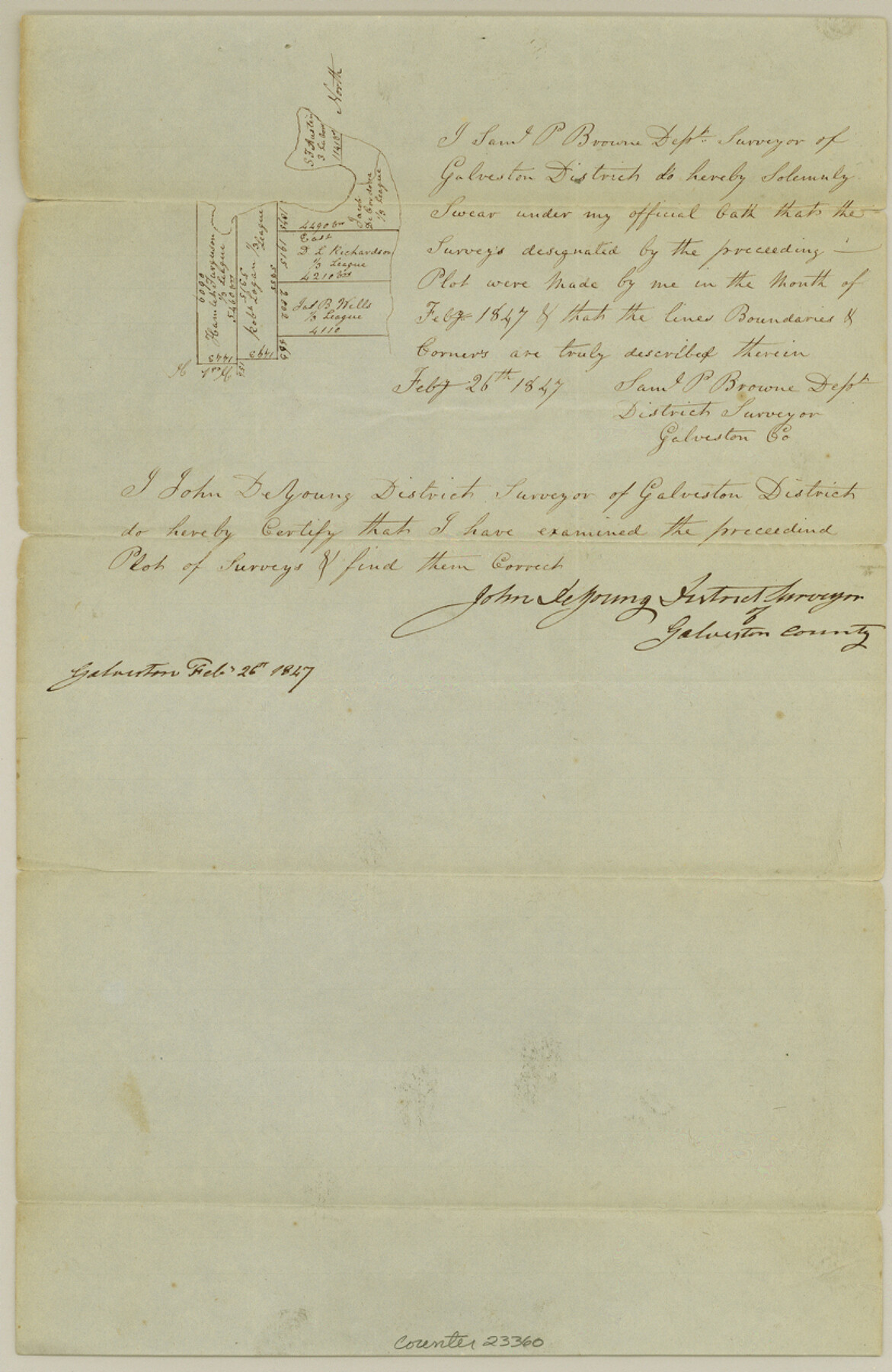
Galveston County Sketch File 5a
[Sketch and explanation of surveys around the Robert Logan tract]
-
Map/Doc
23360
-
Collection
General Map Collection
-
Object Dates
1847/2/26 (Creation Date)
1847 (Survey Date)
-
People and Organizations
Samuel P. Browne (Surveyor/Engineer)
-
Counties
Galveston
-
Subjects
Surveying Sketch File
-
Height x Width
12.6 x 8.2 inches
32.0 x 20.8 cm
-
Medium
paper, manuscript
Part of: General Map Collection
Flight Mission No. CON-2R, Frame 173, Stonewall County

Print $20.00
- Digital $50.00
Flight Mission No. CON-2R, Frame 173, Stonewall County
1957
Size 18.3 x 22.1 inches
Map/Doc 86991
Flight Mission No. CRK-7P, Frame 27, Refugio County

Print $20.00
- Digital $50.00
Flight Mission No. CRK-7P, Frame 27, Refugio County
1956
Size 18.3 x 22.1 inches
Map/Doc 86947
McMullen County Boundary File 7

Print $5.00
- Digital $50.00
McMullen County Boundary File 7
Size 7.2 x 17.0 inches
Map/Doc 57017
Flight Mission No. DQO-3K, Frame 16, Galveston County

Print $20.00
- Digital $50.00
Flight Mission No. DQO-3K, Frame 16, Galveston County
1952
Size 18.9 x 22.5 inches
Map/Doc 85057
Atascosa County Sketch File A

Print $40.00
- Digital $50.00
Atascosa County Sketch File A
Size 16.3 x 15.6 inches
Map/Doc 10869
Flight Mission No. CUG-3P, Frame 194, Kleberg County

Print $20.00
- Digital $50.00
Flight Mission No. CUG-3P, Frame 194, Kleberg County
1956
Size 18.4 x 22.2 inches
Map/Doc 86298
Borden County Sketch File 4

Print $24.00
- Digital $50.00
Borden County Sketch File 4
1903
Size 8.8 x 7.8 inches
Map/Doc 14707
Map of Hamilton County

Print $20.00
- Digital $50.00
Map of Hamilton County
1872
Size 15.0 x 21.9 inches
Map/Doc 4557
Glasscock County Working Sketch 14

Print $40.00
- Digital $50.00
Glasscock County Working Sketch 14
1984
Size 67.0 x 42.1 inches
Map/Doc 63187
Val Verde County Sketch File 25

Print $20.00
- Digital $50.00
Val Verde County Sketch File 25
Size 19.8 x 24.6 inches
Map/Doc 12572
Map of Cottle County

Print $20.00
- Digital $50.00
Map of Cottle County
1893
Size 23.1 x 19.4 inches
Map/Doc 3451
Gregg County Rolled Sketch 16

Print $20.00
- Digital $50.00
Gregg County Rolled Sketch 16
1942
Size 29.0 x 36.7 inches
Map/Doc 6038
You may also like
Burleson County Working Sketch 6

Print $20.00
- Digital $50.00
Burleson County Working Sketch 6
1980
Size 22.3 x 16.0 inches
Map/Doc 67725
Galveston Bay Entrance - Galveston and Texas City Harbors

Print $40.00
- Digital $50.00
Galveston Bay Entrance - Galveston and Texas City Harbors
1975
Size 37.4 x 53.5 inches
Map/Doc 69864
Hale County Sketch File 19

Print $4.00
- Digital $50.00
Hale County Sketch File 19
Size 8.4 x 8.8 inches
Map/Doc 24751
[Blocks A, B and C]
![89867, [Blocks A, B and C], Twichell Survey Records](https://historictexasmaps.com/wmedia_w700/maps/89867-1.tif.jpg)
Print $40.00
- Digital $50.00
[Blocks A, B and C]
Size 36.0 x 59.0 inches
Map/Doc 89867
General Highway Map. Detail of Cities and Towns in Dallas County, Texas [Dallas and vicinity]
![79434, General Highway Map. Detail of Cities and Towns in Dallas County, Texas [Dallas and vicinity], Texas State Library and Archives](https://historictexasmaps.com/wmedia_w700/maps/79434.tif.jpg)
Print $20.00
General Highway Map. Detail of Cities and Towns in Dallas County, Texas [Dallas and vicinity]
1961
Size 18.0 x 24.7 inches
Map/Doc 79434
Lampasas County Working Sketch 9

Print $40.00
- Digital $50.00
Lampasas County Working Sketch 9
1963
Size 32.9 x 56.3 inches
Map/Doc 70286
Refugio County Aerial Photograph Index Sheet 5

Print $20.00
- Digital $50.00
Refugio County Aerial Photograph Index Sheet 5
1957
Size 23.2 x 18.9 inches
Map/Doc 83743
Callahan County

Print $20.00
- Digital $50.00
Callahan County
1879
Size 22.0 x 17.9 inches
Map/Doc 3362
Right of Way and Track Map, International & Gt. Northern Ry. Operated by the International & Gt. Northern Ry. Co., Gulf Division

Print $40.00
- Digital $50.00
Right of Way and Track Map, International & Gt. Northern Ry. Operated by the International & Gt. Northern Ry. Co., Gulf Division
1917
Size 25.1 x 56.6 inches
Map/Doc 64252
San Patricio County Sketch File 54

Print $86.00
- Digital $50.00
San Patricio County Sketch File 54
1997
Size 11.0 x 8.5 inches
Map/Doc 41769
Map of Texas from the most recent authorities

Print $20.00
- Digital $50.00
Map of Texas from the most recent authorities
1845
Size 14.2 x 18.0 inches
Map/Doc 96628
Irion County Rolled Sketch 6

Print $20.00
- Digital $50.00
Irion County Rolled Sketch 6
Size 23.6 x 39.9 inches
Map/Doc 6320