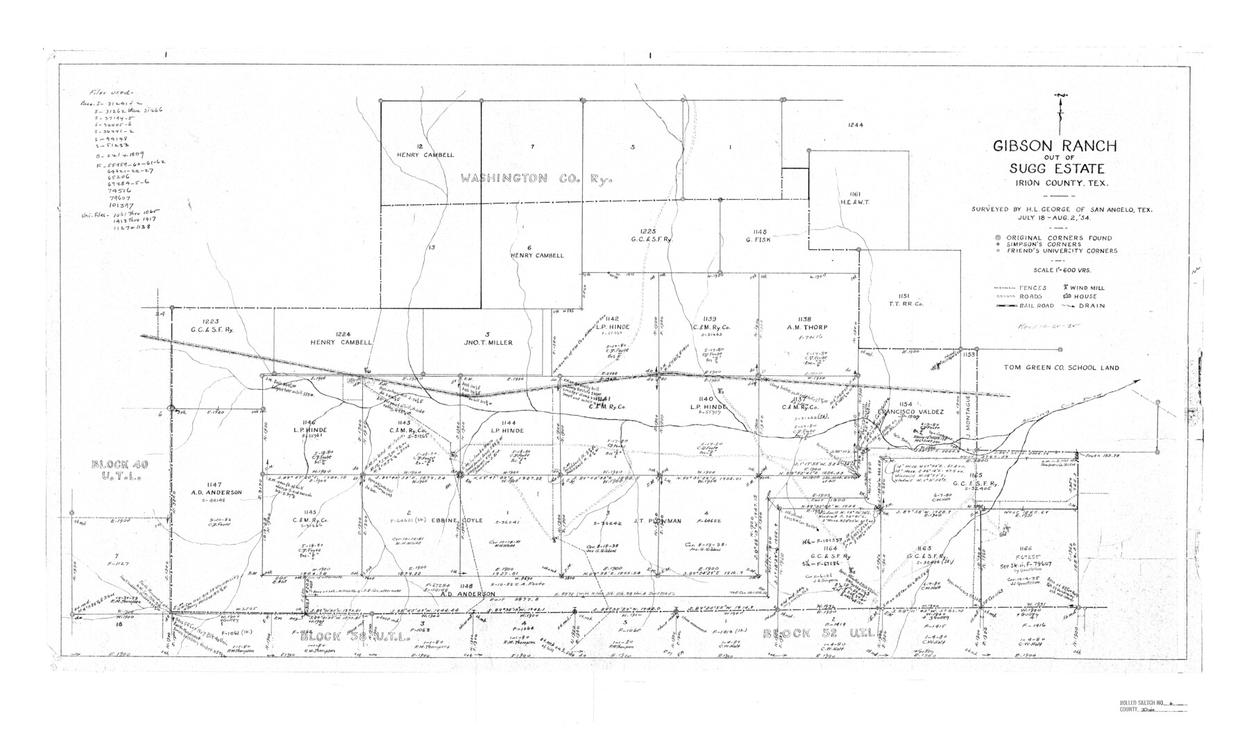
Irion County Rolled Sketch 6
Gibson Ranch out of Sugg Estate
-
Map/Doc
6320
-
Collection
General Map Collection
-
Object Dates
1934/8/2 (Survey Date)
1935/10/25 (File Date)
-
People and Organizations
H.L. George (Surveyor/Engineer)
-
Counties
Irion
-
Subjects
Surveying Rolled Sketch
-
Height x Width
23.6 x 39.9 inches
59.9 x 101.3 cm
-
Scale
1" = 600 varas
-
Comments
See Irion County Sketch File 18 (27494) for correspondence.
Related maps
Irion County Sketch File 18

Print $10.00
- Digital $50.00
Irion County Sketch File 18
Size 11.2 x 8.7 inches
Map/Doc 27494
Part of: General Map Collection
Map of Armstrong County

Print $20.00
- Digital $50.00
Map of Armstrong County
1886
Size 23.0 x 18.6 inches
Map/Doc 3244
Knox County Sketch File 22

Print $6.00
- Digital $50.00
Knox County Sketch File 22
1931
Size 11.2 x 8.8 inches
Map/Doc 29251
Andrews County Rolled Sketch 11A

Print $20.00
- Digital $50.00
Andrews County Rolled Sketch 11A
1933
Size 28.1 x 37.4 inches
Map/Doc 77162
Shelby County Sketch File 34

Print $3.00
- Digital $50.00
Shelby County Sketch File 34
1847
Size 10.1 x 15.7 inches
Map/Doc 36674
Ward County Working Sketch Graphic Index - sheet B

Print $40.00
- Digital $50.00
Ward County Working Sketch Graphic Index - sheet B
1932
Size 30.5 x 52.5 inches
Map/Doc 76732
Bell County Rolled Sketch 2

Print $20.00
- Digital $50.00
Bell County Rolled Sketch 2
1954
Size 27.0 x 28.0 inches
Map/Doc 5133
Fort Bend County Working Sketch 9

Print $20.00
- Digital $50.00
Fort Bend County Working Sketch 9
1932
Size 38.7 x 16.0 inches
Map/Doc 69215
Ochiltree County Working Sketch 5

Print $40.00
- Digital $50.00
Ochiltree County Working Sketch 5
1961
Size 110.0 x 37.3 inches
Map/Doc 71318
McCulloch County Boundary File 64

Print $36.00
- Digital $50.00
McCulloch County Boundary File 64
Size 9.2 x 8.9 inches
Map/Doc 56919
Parker County Working Sketch 17

Print $20.00
- Digital $50.00
Parker County Working Sketch 17
1996
Map/Doc 71467
Brewster County Rolled Sketch 127

Print $20.00
- Digital $50.00
Brewster County Rolled Sketch 127
1969
Size 39.0 x 43.8 inches
Map/Doc 8521
Nueces County Rolled Sketch 38

Print $458.00
- Digital $50.00
Nueces County Rolled Sketch 38
Size 10.1 x 16.4 inches
Map/Doc 47717
You may also like
Jasper County Boundary File 1

Print $50.00
- Digital $50.00
Jasper County Boundary File 1
Size 12.6 x 20.5 inches
Map/Doc 55462
Houston County Working Sketch 37

Print $20.00
- Digital $50.00
Houston County Working Sketch 37
2006
Size 33.0 x 40.0 inches
Map/Doc 83627
[San Antonio & Aransas Pass]
![64208, [San Antonio & Aransas Pass], General Map Collection](https://historictexasmaps.com/wmedia_w700/maps/64208.tif.jpg)
Print $40.00
- Digital $50.00
[San Antonio & Aransas Pass]
Size 17.0 x 50.7 inches
Map/Doc 64208
Sutton County Sketch File 1

Print $6.00
- Digital $50.00
Sutton County Sketch File 1
1885
Size 14.3 x 8.9 inches
Map/Doc 37348
Colorado County Working Sketch 15

Print $40.00
- Digital $50.00
Colorado County Working Sketch 15
1949
Size 31.4 x 63.3 inches
Map/Doc 68115
Flight Mission No. DQO-11K, Frame 25, Galveston County

Print $20.00
- Digital $50.00
Flight Mission No. DQO-11K, Frame 25, Galveston County
1952
Size 18.8 x 22.4 inches
Map/Doc 85222
Schleicher County Rolled Sketch 7

Print $20.00
- Digital $50.00
Schleicher County Rolled Sketch 7
Size 32.5 x 37.9 inches
Map/Doc 9904
Travis County Rolled Sketch 47

Print $40.00
- Digital $50.00
Travis County Rolled Sketch 47
1923
Size 57.3 x 26.5 inches
Map/Doc 10626
Flight Mission No. DQO-11K, Frame 27, Galveston County

Print $20.00
- Digital $50.00
Flight Mission No. DQO-11K, Frame 27, Galveston County
1952
Size 18.8 x 22.4 inches
Map/Doc 85224
Travis County Sketch File 51

Print $8.00
- Digital $50.00
Travis County Sketch File 51
1941
Size 14.3 x 8.9 inches
Map/Doc 38387
Liberty County Sketch File 52

Print $20.00
- Digital $50.00
Liberty County Sketch File 52
Size 17.5 x 13.5 inches
Map/Doc 11995
Flight Mission No. CRC-4R, Frame 176, Chambers County

Print $20.00
- Digital $50.00
Flight Mission No. CRC-4R, Frame 176, Chambers County
1956
Size 18.6 x 22.3 inches
Map/Doc 84927