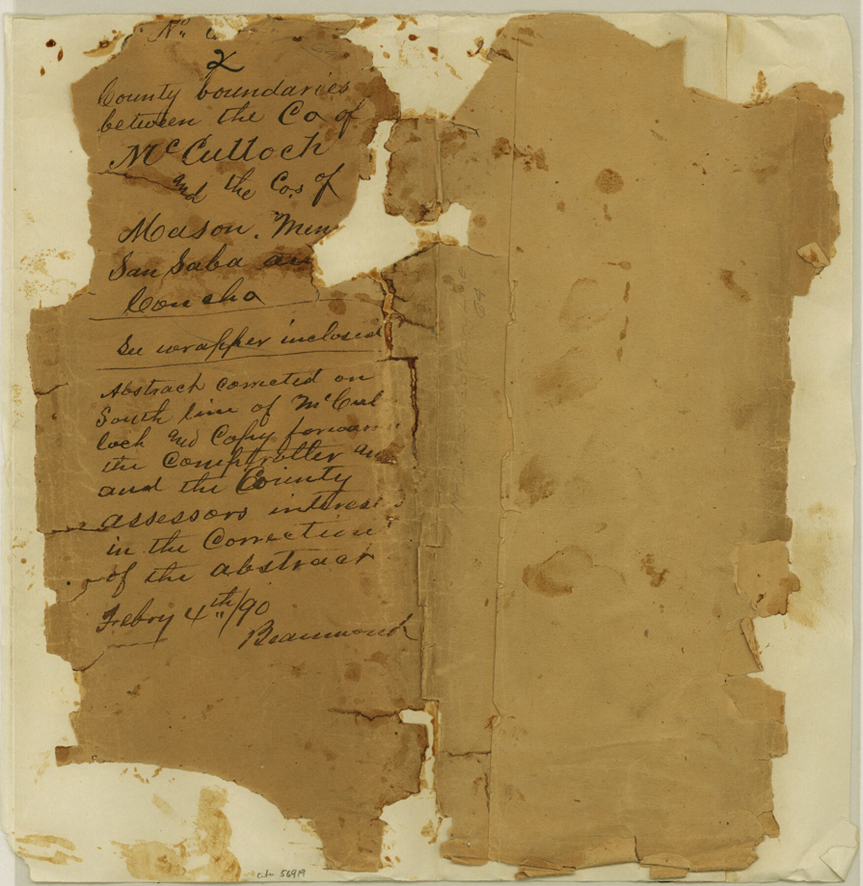
McCulloch County Boundary File 64
Field Notes of McCulloch Co. line as Established 1885 by Chas. Harcourt C. Surveyor of McCullock Co., Texas
-
Map/Doc
56919
-
Collection
General Map Collection
-
Counties
McCulloch
-
Subjects
County Boundaries
-
Height x Width
9.2 x 8.9 inches
23.4 x 22.6 cm
Part of: General Map Collection
Navigation Maps of Gulf Intracoastal Waterway, Port Arthur to Brownsville, Texas

Print $4.00
- Digital $50.00
Navigation Maps of Gulf Intracoastal Waterway, Port Arthur to Brownsville, Texas
1951
Size 16.7 x 21.5 inches
Map/Doc 65424
Texas Intracoastal Waterway - Matagorda Bay, Cedar Lakes to Oyster Lake

Print $20.00
- Digital $50.00
Texas Intracoastal Waterway - Matagorda Bay, Cedar Lakes to Oyster Lake
1960
Size 27.1 x 38.9 inches
Map/Doc 73370
Presidio County Boundary File 3a

Print $40.00
- Digital $50.00
Presidio County Boundary File 3a
Size 17.7 x 38.0 inches
Map/Doc 58074
Starr County Sketch File 40

Print $4.00
- Digital $50.00
Starr County Sketch File 40
1940
Size 14.2 x 8.8 inches
Map/Doc 36989

Padre Island National Seashore

Print $4.00
- Digital $50.00
Padre Island National Seashore
Size 16.1 x 22.3 inches
Map/Doc 60535
Hall County Sketch File C2

Print $6.00
- Digital $50.00
Hall County Sketch File C2
1905
Size 14.4 x 9.0 inches
Map/Doc 24789
Midland County Working Sketch 29

Print $40.00
- Digital $50.00
Midland County Working Sketch 29
1971
Size 49.4 x 35.6 inches
Map/Doc 71010
Kent County Sketch File A

Print $4.00
- Digital $50.00
Kent County Sketch File A
Size 8.2 x 9.0 inches
Map/Doc 28821
Crockett County Sketch File 78

Print $20.00
- Digital $50.00
Crockett County Sketch File 78
1931
Size 29.4 x 19.1 inches
Map/Doc 11235
Liberty County Working Sketch 91a

Print $40.00
- Digital $50.00
Liberty County Working Sketch 91a
1919
Size 48.6 x 42.1 inches
Map/Doc 65457
Nueces County Rolled Sketch 120

Print $100.00
Nueces County Rolled Sketch 120
1989
Size 11.2 x 10.7 inches
Map/Doc 9636
You may also like

Carta Esférica del Seno Mexicano y Canales Viexo y de Bama

Carta Esférica del Seno Mexicano y Canales Viexo y de Bama
1797
Size 26.7 x 47.1 inches
Map/Doc 94569
Shackelford County Sketch File 9

Print $20.00
- Digital $50.00
Shackelford County Sketch File 9
1918
Size 24.3 x 15.5 inches
Map/Doc 12315
Kerr County Sketch File 6b

Print $4.00
- Digital $50.00
Kerr County Sketch File 6b
1880
Size 8.5 x 13.6 inches
Map/Doc 28867

San Patricio County Rolled Sketch 43

Print $1233.00
- Digital $50.00
San Patricio County Rolled Sketch 43
Size 8.8 x 14.2 inches
Map/Doc 41814
Pecos County Texas

Print $20.00
- Digital $50.00
Pecos County Texas
Size 23.6 x 19.3 inches
Map/Doc 3950
Dallas, Texas. With the Projected River and Navigation Improvements. Viewed from Above the Sister City of Oak Cliff

Print $20.00
Dallas, Texas. With the Projected River and Navigation Improvements. Viewed from Above the Sister City of Oak Cliff
1892
Size 20.9 x 29.7 inches
Map/Doc 93474
Houston, Texas - Where 17 Railroads meet the Sea

Houston, Texas - Where 17 Railroads meet the Sea
1922
Size 8.5 x 10.4 inches
Map/Doc 97070
Burnet County Working Sketch 11

Print $20.00
- Digital $50.00
Burnet County Working Sketch 11
1975
Size 26.5 x 28.9 inches
Map/Doc 67854
[Southwest part of H. & G. N. Block 8]
![90372, [Southwest part of H. & G. N. Block 8], Twichell Survey Records](https://historictexasmaps.com/wmedia_w700/maps/90372-1.tif.jpg)
Print $20.00
- Digital $50.00
[Southwest part of H. & G. N. Block 8]
Size 24.6 x 9.3 inches
Map/Doc 90372
Wilbarger Co.

Print $20.00
- Digital $50.00
Wilbarger Co.
1949
Size 46.8 x 38.1 inches
Map/Doc 77458