Crockett County Sketch File 78
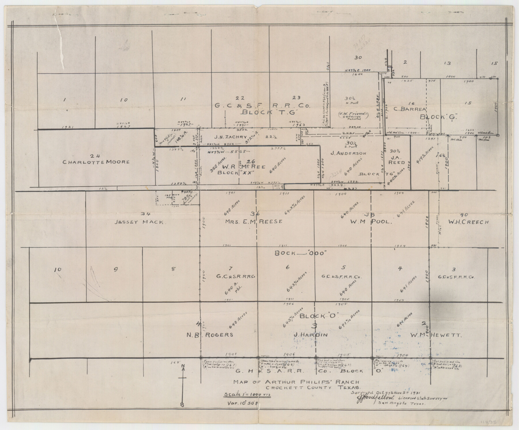
Map of Arthur Philips' Ranch
-
Map/Doc
11235
-
Collection
General Map Collection
-
Object Dates
1931/11/2 (Creation Date)
1931/11/2 (Survey Date)
-
People and Organizations
J.J. Goodfellow (Surveyor/Engineer)
-
Counties
Crockett
-
Subjects
Surveying Sketch File
-
Height x Width
29.4 x 19.1 inches
74.7 x 48.5 cm
-
Medium
multi-page, multi-format
-
Scale
1:1000
Part of: General Map Collection
Val Verde County Sketch File XXX8

Print $6.00
- Digital $50.00
Val Verde County Sketch File XXX8
Size 9.0 x 16.4 inches
Map/Doc 39106
Le Nouveau Mexique et la Floride: Tirèes de diverses cartes, et relations

Print $20.00
- Digital $50.00
Le Nouveau Mexique et la Floride: Tirèes de diverses cartes, et relations
1656
Size 17.2 x 22.8 inches
Map/Doc 95833
Palo Pinto County Rolled Sketch 5

Print $40.00
- Digital $50.00
Palo Pinto County Rolled Sketch 5
Size 54.4 x 36.0 inches
Map/Doc 76021

Travis County

Print $40.00
- Digital $50.00
Travis County
1880
Size 59.4 x 68.7 inches
Map/Doc 16903
Galveston County Working Sketch 4

Print $20.00
- Digital $50.00
Galveston County Working Sketch 4
1930
Size 19.7 x 17.2 inches
Map/Doc 69341
Sterling County Sketch File 6

Print $12.00
- Digital $50.00
Sterling County Sketch File 6
1912
Size 5.7 x 8.8 inches
Map/Doc 37115
Jasper County Sketch File 12

Print $4.00
- Digital $50.00
Jasper County Sketch File 12
Size 8.8 x 10.0 inches
Map/Doc 27792
Presidio County Sketch File 30

Print $10.00
- Digital $50.00
Presidio County Sketch File 30
1890
Size 10.3 x 8.1 inches
Map/Doc 34468
Henderson County Rolled Sketch 11

Print $20.00
- Digital $50.00
Henderson County Rolled Sketch 11
1915
Size 29.2 x 42.9 inches
Map/Doc 76149
Travis County Working Sketch 65

Print $20.00
- Digital $50.00
Travis County Working Sketch 65
2003
Size 28.1 x 38.3 inches
Map/Doc 78494

You may also like
Flight Mission No. BRE-2P, Frame 43, Nueces County

Print $20.00
- Digital $50.00
Flight Mission No. BRE-2P, Frame 43, Nueces County
1956
Size 18.8 x 22.7 inches
Map/Doc 86745
Kent County Working Sketch 16

Print $20.00
- Digital $50.00
Kent County Working Sketch 16
1972
Size 32.4 x 31.5 inches
Map/Doc 70023
Sketch in Hardeman Co.

Print $20.00
- Digital $50.00
Sketch in Hardeman Co.
1890
Size 17.8 x 17.6 inches
Map/Doc 558
Ward County Rolled Sketch 3

Print $40.00
- Digital $50.00
Ward County Rolled Sketch 3
Size 65.3 x 25.7 inches
Map/Doc 10101
Kendall County Rolled Sketch 4

Print $20.00
- Digital $50.00
Kendall County Rolled Sketch 4
1945
Size 29.9 x 27.0 inches
Map/Doc 6457
Harris County Working Sketch 96

Print $20.00
- Digital $50.00
Harris County Working Sketch 96
1978
Size 18.2 x 26.6 inches
Map/Doc 65988
Coke County Rolled Sketch 19

Print $20.00
- Digital $50.00
Coke County Rolled Sketch 19
1954
Size 18.5 x 25.8 inches
Map/Doc 5519
Montgomery County Working Sketch 76

Print $20.00
- Digital $50.00
Montgomery County Working Sketch 76
Size 16.5 x 18.3 inches
Map/Doc 78191
Concho County Working Sketch Graphic Index

Print $20.00
- Digital $50.00
Concho County Working Sketch Graphic Index
1947
Size 45.8 x 35.6 inches
Map/Doc 76503
Harris County Historic Topographic 30

Print $20.00
- Digital $50.00
Harris County Historic Topographic 30
1915
Size 29.2 x 22.7 inches
Map/Doc 65841
[Surveys in Austin's Colony along the west bank of the San Jacinto River]
![79, [Surveys in Austin's Colony along the west bank of the San Jacinto River], General Map Collection](https://historictexasmaps.com/wmedia_w700/maps/79-1.tif.jpg)
Print $20.00
- Digital $50.00
[Surveys in Austin's Colony along the west bank of the San Jacinto River]
1831
Size 25.0 x 22.0 inches
Map/Doc 79
United States - Gulf Coast Texas - Northern part of Laguna Madre

Print $20.00
- Digital $50.00
United States - Gulf Coast Texas - Northern part of Laguna Madre
1941
Size 26.9 x 18.3 inches
Map/Doc 72938