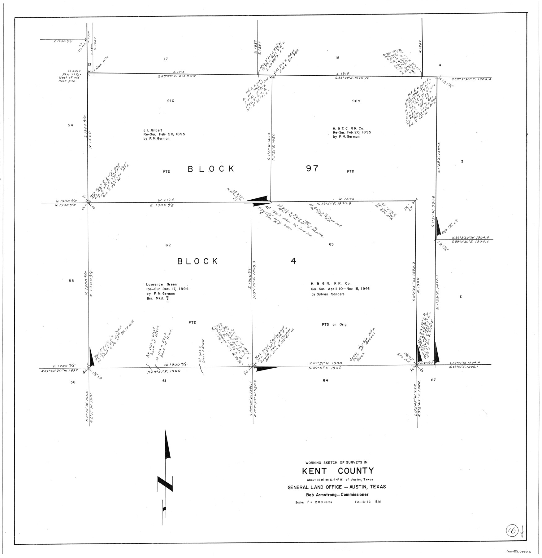
Kent County Working Sketch 16
-
Map/Doc
70023
-
Collection
General Map Collection
-
Object Dates
10/13/1972 (Creation Date)
-
People and Organizations
Elbert Menzel (Draftsman)
-
Counties
Kent
-
Subjects
Surveying Working Sketch
-
Height x Width
32.4 x 31.5 inches
82.3 x 80.0 cm
-
Scale
1" = 200 varas
Part of: General Map Collection
Cottle County Sketch File 4

Print $16.00
- Digital $50.00
Cottle County Sketch File 4
Size 8.2 x 4.2 inches
Map/Doc 19466

Current Miscellaneous File 102

Print $611.00
- Digital $50.00
Current Miscellaneous File 102
Size 11.5 x 7.1 inches
Map/Doc 74379
Webb County Working Sketch 33

Print $20.00
- Digital $50.00
Webb County Working Sketch 33
1938
Size 27.4 x 35.9 inches
Map/Doc 72398
Hays County Working Sketch 10

Print $20.00
- Digital $50.00
Hays County Working Sketch 10
1949
Size 23.4 x 25.8 inches
Map/Doc 66084
Stonewall County Sketch File 12A

Print $20.00
- Digital $50.00
Stonewall County Sketch File 12A
Size 25.6 x 17.4 inches
Map/Doc 12364
A map of Lewis and Clark's track across the western portion of North America from the Mississippi to the Pacific Ocean, by Order of the executive of the United States in 1804, 5, & 6

Print $20.00
- Digital $50.00
A map of Lewis and Clark's track across the western portion of North America from the Mississippi to the Pacific Ocean, by Order of the executive of the United States in 1804, 5, & 6
1814
Size 13.3 x 27.9 inches
Map/Doc 97412
Webb County Rolled Sketch EF5

Print $20.00
- Digital $50.00
Webb County Rolled Sketch EF5
1931
Size 41.4 x 32.0 inches
Map/Doc 8227
Foard County Sketch File 8

Print $6.00
- Digital $50.00
Foard County Sketch File 8
Size 10.5 x 11.8 inches
Map/Doc 22810
Flight Mission No. DQN-2K, Frame 74, Calhoun County

Print $20.00
- Digital $50.00
Flight Mission No. DQN-2K, Frame 74, Calhoun County
1953
Size 18.6 x 22.2 inches
Map/Doc 84266
Coleman County Rolled Sketch 6

Print $20.00
- Digital $50.00
Coleman County Rolled Sketch 6
Size 20.9 x 14.4 inches
Map/Doc 5529
Burnet County Working Sketch 4

Print $20.00
- Digital $50.00
Burnet County Working Sketch 4
1956
Size 18.3 x 33.1 inches
Map/Doc 67847
You may also like
Taylor County Rolled Sketch 24

Print $20.00
- Digital $50.00
Taylor County Rolled Sketch 24
Size 19.6 x 22.7 inches
Map/Doc 7916
Zavala County Sketch File 34

Print $4.00
- Digital $50.00
Zavala County Sketch File 34
1887
Size 13.0 x 8.5 inches
Map/Doc 41395
Coleman County Sketch File 35a

Print $2.00
- Digital $50.00
Coleman County Sketch File 35a
1884
Size 9.9 x 8.9 inches
Map/Doc 18741
Wise County Working Sketch 17

Print $20.00
- Digital $50.00
Wise County Working Sketch 17
1972
Size 29.9 x 25.0 inches
Map/Doc 72631
Map of Red River County

Print $20.00
- Digital $50.00
Map of Red River County
1856
Size 22.2 x 18.4 inches
Map/Doc 3981
Brazoria County Sketch File 9

Print $6.00
- Digital $50.00
Brazoria County Sketch File 9
Size 14.0 x 9.0 inches
Map/Doc 14936
Hunt County Sketch File 28

Print $4.00
- Digital $50.00
Hunt County Sketch File 28
1860
Size 8.5 x 8.2 inches
Map/Doc 27128
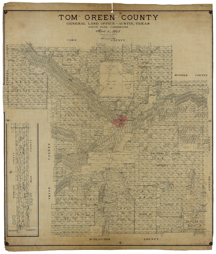
Tom Green County
Print $40.00
- Digital $50.00
Tom Green County
1942
Size 55.4 x 47.6 inches
Map/Doc 63073
[Blocks 341, G-5, G-12, TCRRCo.]
![2069, [Blocks 341, G-5, G-12, TCRRCo.], General Map Collection](https://historictexasmaps.com/wmedia_w700/maps/2069-1.tif.jpg)
Print $20.00
- Digital $50.00
[Blocks 341, G-5, G-12, TCRRCo.]
1954
Size 23.7 x 22.7 inches
Map/Doc 2069
Jeff Davis County Working Sketch 13

Print $20.00
- Digital $50.00
Jeff Davis County Working Sketch 13
1949
Size 24.5 x 32.7 inches
Map/Doc 66508
Aransas County Sketch File 23

Print $6.00
- Digital $50.00
Aransas County Sketch File 23
1927
Size 14.5 x 8.9 inches
Map/Doc 13174
Lavaca County Sketch File 22

Print $28.00
- Digital $50.00
Lavaca County Sketch File 22
1959
Size 14.2 x 8.7 inches
Map/Doc 29654