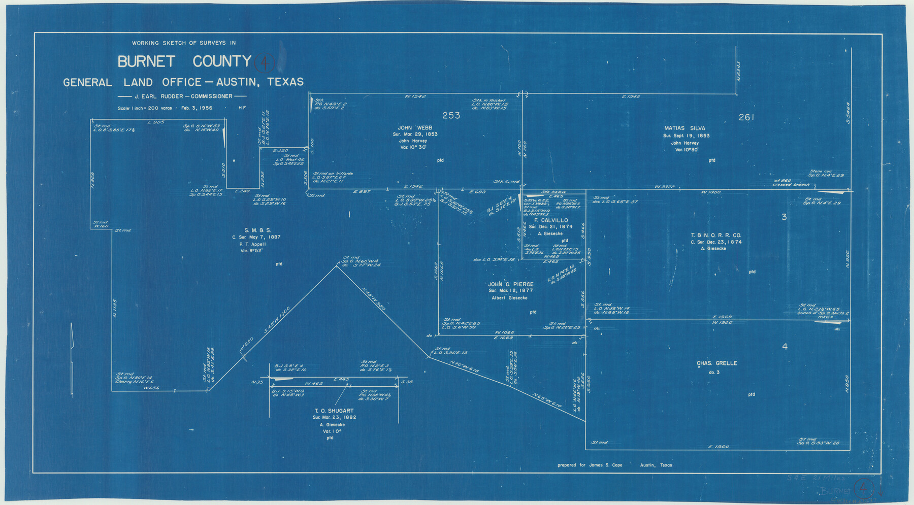
Burnet County Working Sketch 4
-
Map/Doc
67847
-
Collection
General Map Collection
-
Object Dates
2/3/1956 (Creation Date)
-
People and Organizations
Herman Forbes (Draftsman)
-
Counties
Burnet
-
Subjects
Surveying Working Sketch
-
Height x Width
18.3 x 33.1 inches
46.5 x 84.1 cm
-
Scale
1" = 200 varas
Part of: General Map Collection
Winkler County Working Sketch 10

Print $40.00
- Digital $50.00
Winkler County Working Sketch 10
1960
Size 30.3 x 61.0 inches
Map/Doc 72604

Hutchinson County Working Sketch 36

Print $20.00
- Digital $50.00
Hutchinson County Working Sketch 36
1978
Size 27.2 x 22.4 inches
Map/Doc 66396
Kimble County Working Sketch 56

Print $20.00
- Digital $50.00
Kimble County Working Sketch 56
1957
Size 34.6 x 41.9 inches
Map/Doc 70124
Haskell County Sketch File A

Print $4.00
- Digital $50.00
Haskell County Sketch File A
Size 7.8 x 11.9 inches
Map/Doc 26117
Irion County Rolled Sketch 19

Print $20.00
- Digital $50.00
Irion County Rolled Sketch 19
Size 19.3 x 27.5 inches
Map/Doc 6328
Lee County Rolled Sketch 1

Print $40.00
- Digital $50.00
Lee County Rolled Sketch 1
1939
Size 71.1 x 45.2 inches
Map/Doc 9562
Stonewall County Rolled Sketch 32

Print $20.00
- Digital $50.00
Stonewall County Rolled Sketch 32
1951
Size 19.4 x 33.6 inches
Map/Doc 7876
Kerr County Sketch File 24

Print $20.00
- Digital $50.00
Kerr County Sketch File 24
1967
Size 15.7 x 21.6 inches
Map/Doc 11923
Eastland County Working Sketch 11

Print $20.00
- Digital $50.00
Eastland County Working Sketch 11
1919
Size 20.2 x 16.7 inches
Map/Doc 68792
Stephens County Boundary File 3

Print $25.00
- Digital $50.00
Stephens County Boundary File 3
Size 14.2 x 8.8 inches
Map/Doc 58882
Oldham County Boundary File 1b

Print $48.00
- Digital $50.00
Oldham County Boundary File 1b
Size 14.0 x 8.5 inches
Map/Doc 57747
You may also like
Flight Mission No. CLL-3N, Frame 39, Willacy County

Print $20.00
- Digital $50.00
Flight Mission No. CLL-3N, Frame 39, Willacy County
1954
Size 18.3 x 22.0 inches
Map/Doc 87097
[Nathaniel H. Cochran Survey and Vicinity]
![91496, [Nathaniel H. Cochran Survey and Vicinity], Twichell Survey Records](https://historictexasmaps.com/wmedia_w700/maps/91496-1.tif.jpg)
Print $20.00
- Digital $50.00
[Nathaniel H. Cochran Survey and Vicinity]
1922
Size 22.5 x 21.9 inches
Map/Doc 91496
Montgomery County Rolled Sketch 13

Print $40.00
- Digital $50.00
Montgomery County Rolled Sketch 13
1932
Size 37.9 x 57.3 inches
Map/Doc 9526
Maps of Gulf Intracoastal Waterway, Texas - Sabine River to the Rio Grande and connecting waterways including ship channels

Print $20.00
- Digital $50.00
Maps of Gulf Intracoastal Waterway, Texas - Sabine River to the Rio Grande and connecting waterways including ship channels
1966
Size 14.6 x 22.5 inches
Map/Doc 61935
Hood County Working Sketch 16

Print $40.00
- Digital $50.00
Hood County Working Sketch 16
1987
Size 45.2 x 71.4 inches
Map/Doc 66210
Jeff Davis County Rolled Sketch 45

Print $40.00
- Digital $50.00
Jeff Davis County Rolled Sketch 45
2005
Size 91.3 x 44.0 inches
Map/Doc 87207
Bosque County, Texas

Print $20.00
- Digital $50.00
Bosque County, Texas
1879
Size 25.1 x 29.9 inches
Map/Doc 420
Webb County Sketch File 55

Print $20.00
- Digital $50.00
Webb County Sketch File 55
1940
Size 20.6 x 12.6 inches
Map/Doc 12650
Located Line of the Panhandle & Gulf Ry. through State Lands

Print $40.00
- Digital $50.00
Located Line of the Panhandle & Gulf Ry. through State Lands
1904
Size 12.4 x 78.0 inches
Map/Doc 64104
Flight Mission No. DQN-2K, Frame 138, Calhoun County

Print $20.00
- Digital $50.00
Flight Mission No. DQN-2K, Frame 138, Calhoun County
1953
Size 16.1 x 16.0 inches
Map/Doc 84307
Pecos County Working Sketch 59

Print $20.00
- Digital $50.00
Pecos County Working Sketch 59
1950
Size 26.5 x 34.1 inches
Map/Doc 71531
Hudspeth County Rolled Sketch 49

Print $40.00
- Digital $50.00
Hudspeth County Rolled Sketch 49
Size 42.8 x 53.8 inches
Map/Doc 9219