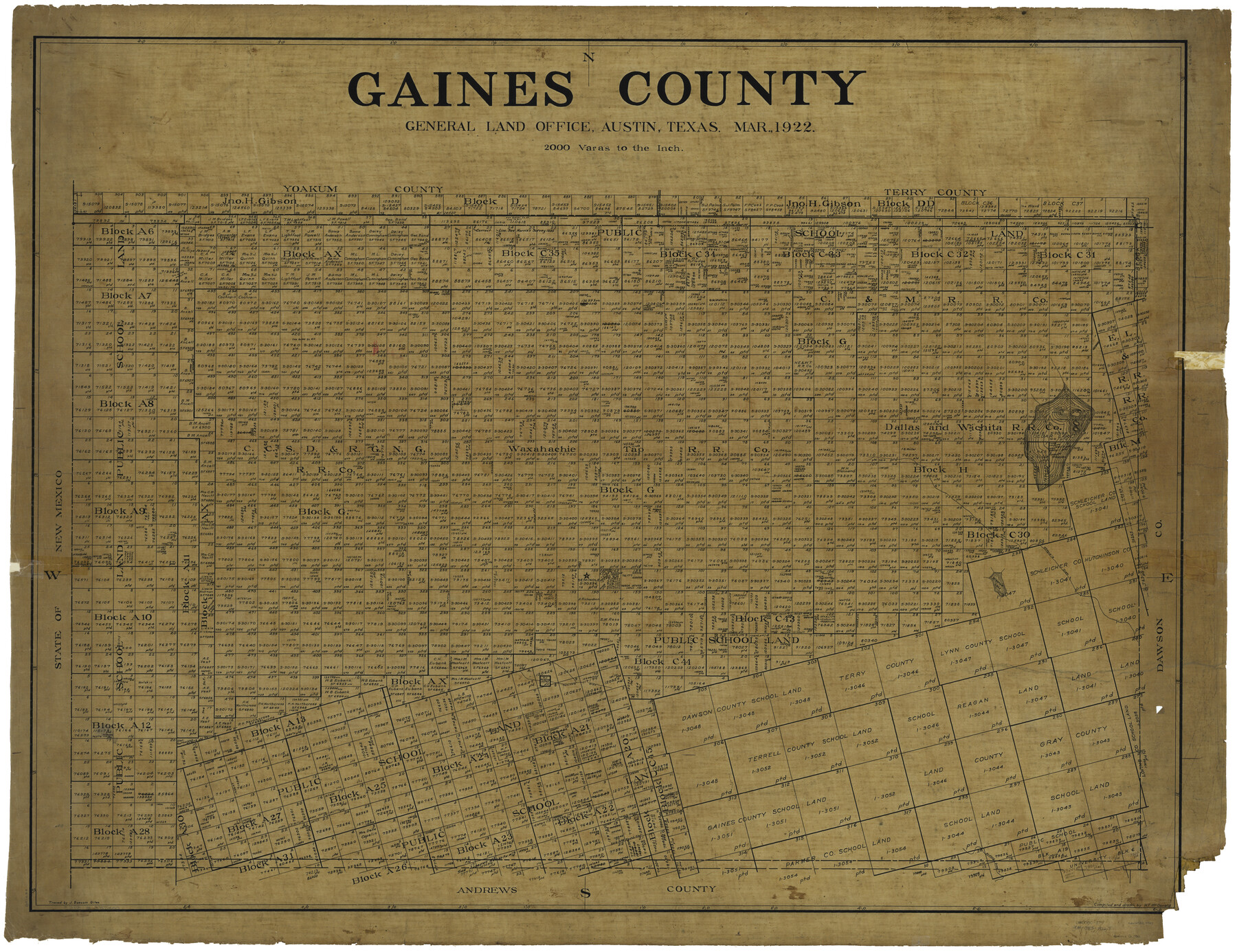
Gaines County
-
Map/Doc
4953
-
Collection
General Map Collection
-
Object Dates
3/1922 (Creation Date)
-
People and Organizations
Texas General Land Office (Publisher)
H.F. McDonald (Draftsman)
H.F. McDonald (Compiler)
-
Counties
Gaines
-
Subjects
County
-
Height x Width
42.4 x 55.1 inches
107.7 x 140.0 cm
-
Comments
Traced by J. Bascom Giles.
Part of: General Map Collection
Goliad County Working Sketch 19

Print $20.00
- Digital $50.00
Goliad County Working Sketch 19
1954
Size 31.5 x 31.8 inches
Map/Doc 63209
History of the Geography of Texas

Print $40.00
- Digital $50.00
History of the Geography of Texas
1897
Size 70.7 x 52.9 inches
Map/Doc 3095
Intracoastal Waterway, Houma, LA to Corpus Christi, TX

Print $5.00
- Digital $50.00
Intracoastal Waterway, Houma, LA to Corpus Christi, TX
Size 22.0 x 30.0 inches
Map/Doc 61912
Presidio County Sketch File U

Print $10.00
- Digital $50.00
Presidio County Sketch File U
1914
Size 10.2 x 8.2 inches
Map/Doc 34544
Flight Mission No. DQN-1K, Frame 145, Calhoun County

Print $20.00
- Digital $50.00
Flight Mission No. DQN-1K, Frame 145, Calhoun County
1953
Size 18.6 x 22.3 inches
Map/Doc 84208
Harris County NRC Article 33.136 Sketch 12

Print $30.00
- Digital $50.00
Harris County NRC Article 33.136 Sketch 12
2007
Size 24.0 x 17.5 inches
Map/Doc 94627
Anderson County Sketch File 6

Print $4.00
- Digital $50.00
Anderson County Sketch File 6
Size 12.5 x 8.2 inches
Map/Doc 12753
Railroad and County Map of Texas

Print $20.00
- Digital $50.00
Railroad and County Map of Texas
1926
Size 42.9 x 45.2 inches
Map/Doc 65799
Flight Mission No. BRE-1P, Frame 6, Nueces County

Print $20.00
- Digital $50.00
Flight Mission No. BRE-1P, Frame 6, Nueces County
1956
Size 18.2 x 22.1 inches
Map/Doc 86614
Pecos County Rolled Sketch 60

Print $20.00
- Digital $50.00
Pecos County Rolled Sketch 60
1926
Size 18.3 x 24.2 inches
Map/Doc 7232
Uvalde County Working Sketch 34

Print $20.00
- Digital $50.00
Uvalde County Working Sketch 34
1963
Size 31.6 x 42.8 inches
Map/Doc 72104
Upton County Sketch File 4

Print $40.00
- Digital $50.00
Upton County Sketch File 4
1886
Size 19.5 x 9.0 inches
Map/Doc 12510
You may also like
Oldham County

Print $20.00
- Digital $50.00
Oldham County
1888
Size 19.6 x 16.5 inches
Map/Doc 93018
Liberty County Sketch File 41

Print $2.00
- Digital $50.00
Liberty County Sketch File 41
1872
Size 12.5 x 8.5 inches
Map/Doc 29997
Randall County Rolled Sketch 2

Print $20.00
- Digital $50.00
Randall County Rolled Sketch 2
1941
Size 31.9 x 23.9 inches
Map/Doc 7422
[Sketch for Mineral Application 24072, San Jacinto River]
![65599, [Sketch for Mineral Application 24072, San Jacinto River], General Map Collection](https://historictexasmaps.com/wmedia_w700/maps/65599.tif.jpg)
Print $20.00
- Digital $50.00
[Sketch for Mineral Application 24072, San Jacinto River]
1929
Size 23.5 x 18.0 inches
Map/Doc 65599
Cooke County Sketch File 21

Print $4.00
- Digital $50.00
Cooke County Sketch File 21
Size 9.0 x 6.7 inches
Map/Doc 19265
Map of Bexar County

Print $20.00
- Digital $50.00
Map of Bexar County
1896
Size 45.2 x 40.2 inches
Map/Doc 4885
Zapata County Sketch File 8

Print $40.00
- Digital $50.00
Zapata County Sketch File 8
1917
Size 59.5 x 26.5 inches
Map/Doc 10438
Smith County Rolled Sketch 6E1

Print $20.00
- Digital $50.00
Smith County Rolled Sketch 6E1
1966
Size 27.4 x 22.7 inches
Map/Doc 10612
Webb County Sketch File 13b

Print $3.00
- Digital $50.00
Webb County Sketch File 13b
1893
Size 14.0 x 9.8 inches
Map/Doc 39803
Flight Mission No. BRA-3M, Frame 197, Jefferson County

Print $20.00
- Digital $50.00
Flight Mission No. BRA-3M, Frame 197, Jefferson County
1953
Size 18.6 x 22.4 inches
Map/Doc 85412
Sabine Pass and mouth of the River Sabine

Print $20.00
- Digital $50.00
Sabine Pass and mouth of the River Sabine
1840
Size 27.0 x 18.3 inches
Map/Doc 72726
[Coleman County Sections 359, 360, and 361]
![92552, [Coleman County Sections 359, 360, and 361], Twichell Survey Records](https://historictexasmaps.com/wmedia_w700/maps/92552-1.tif.jpg)
Print $20.00
- Digital $50.00
[Coleman County Sections 359, 360, and 361]
1946
Size 17.6 x 22.6 inches
Map/Doc 92552