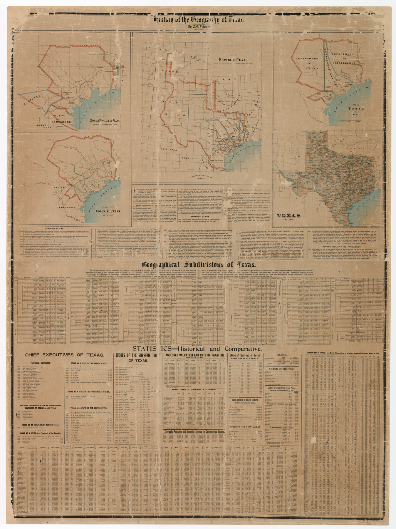
History of the Geography of Texas
K-4-34
-
Map/Doc
3095
-
Collection
General Map Collection
-
Object Dates
1897 (Creation Date)
-
People and Organizations
The Caxton Company (Author)
Z.T. Fulmore (Draftsman)
-
Subjects
State of Texas
-
Height x Width
70.7 x 52.9 inches
179.6 x 134.4 cm
-
Comments
Has tables and lists of facts plus small maps of Texas showing historical political divisions. See maps 93410-93414 for individual maps cropped from this larger item.
See Tracing the Sabine River: The History of Texas' Eastern Boundary for a StoryMap exploring this chapter in Texas' border history.
Conservation funded in 2003 with donation from Texas Monthly.
Related maps
Colonial Texas. 1822 to 1834.

Print $20.00
- Digital $50.00
Colonial Texas. 1822 to 1834.
1897
Size 12.8 x 16.3 inches
Map/Doc 93410
Republic of Texas and boundaries as claimed by Texas from Decr. 19th, 1836 to Novr. 26th, 1850

Print $20.00
- Digital $50.00
Republic of Texas and boundaries as claimed by Texas from Decr. 19th, 1836 to Novr. 26th, 1850
1897
Size 20.7 x 19.3 inches
Map/Doc 93411
Spanish Province of Texas compiled from map on file among archives at Saltillo

Print $20.00
- Digital $50.00
Spanish Province of Texas compiled from map on file among archives at Saltillo
1897
Size 13.6 x 16.0 inches
Map/Doc 93412
Texas since 1850

Print $20.00
- Digital $50.00
Texas since 1850
1897
Size 13.3 x 15.5 inches
Map/Doc 93413
Texas in 1835

Print $20.00
- Digital $50.00
Texas in 1835
1897
Size 13.4 x 15.3 inches
Map/Doc 93414
Part of: General Map Collection
Hudspeth County Rolled Sketch 38

Print $20.00
- Digital $50.00
Hudspeth County Rolled Sketch 38
1939
Size 18.0 x 37.5 inches
Map/Doc 6251
Swisher County

Print $20.00
- Digital $50.00
Swisher County
1910
Size 45.3 x 39.1 inches
Map/Doc 63054
Wilson County Sketch File 8

Print $8.00
- Digital $50.00
Wilson County Sketch File 8
1879
Size 10.4 x 8.2 inches
Map/Doc 40413
Flight Mission No. BRA-7M, Frame 139, Jefferson County

Print $20.00
- Digital $50.00
Flight Mission No. BRA-7M, Frame 139, Jefferson County
1953
Size 18.7 x 22.4 inches
Map/Doc 85533
Zavala County

Print $40.00
- Digital $50.00
Zavala County
1977
Size 43.6 x 49.3 inches
Map/Doc 95684
Kent County Working Sketch 20

Print $40.00
- Digital $50.00
Kent County Working Sketch 20
1980
Size 50.7 x 44.1 inches
Map/Doc 70027
[Right of Way & Track Map, The Texas & Pacific Ry. Co. Main Line]
![64666, [Right of Way & Track Map, The Texas & Pacific Ry. Co. Main Line], General Map Collection](https://historictexasmaps.com/wmedia_w700/maps/64666.tif.jpg)
Print $20.00
- Digital $50.00
[Right of Way & Track Map, The Texas & Pacific Ry. Co. Main Line]
Size 11.0 x 18.5 inches
Map/Doc 64666

Brewster County Sketch File N-28

Print $40.00
- Digital $50.00
Brewster County Sketch File N-28
Size 23.4 x 24.3 inches
Map/Doc 10973
Lampasas County Working Sketch 24

Print $20.00
- Digital $50.00
Lampasas County Working Sketch 24
Size 14.3 x 13.3 inches
Map/Doc 61796
Map Showing Location of Dallas & Greenville Railroad through Rockwall County, Texas

Print $3.00
- Digital $50.00
Map Showing Location of Dallas & Greenville Railroad through Rockwall County, Texas
Size 7.9 x 17.5 inches
Map/Doc 64485
Flight Mission No. CRC-2R, Frame 119, Chambers County

Print $20.00
- Digital $50.00
Flight Mission No. CRC-2R, Frame 119, Chambers County
1956
Size 18.6 x 22.4 inches
Map/Doc 84743
You may also like
Map of Galveston County, Texas

Print $20.00
- Digital $50.00
Map of Galveston County, Texas
1879
Size 18.3 x 26.6 inches
Map/Doc 546
Flight Mission No. DQN-5K, Frame 56, Calhoun County

Print $20.00
- Digital $50.00
Flight Mission No. DQN-5K, Frame 56, Calhoun County
1953
Size 15.7 x 15.5 inches
Map/Doc 84399
Brewster County Rolled Sketch 78

Print $20.00
- Digital $50.00
Brewster County Rolled Sketch 78
1945
Size 19.8 x 28.0 inches
Map/Doc 5243
Nueces County Rolled Sketch 129 A-C

Print $6.00
- Digital $50.00
Nueces County Rolled Sketch 129 A-C
1998
Size 11.2 x 8.8 inches
Map/Doc 41616
McMullen County Rolled Sketch 11

Print $20.00
- Digital $50.00
McMullen County Rolled Sketch 11
Size 32.2 x 22.3 inches
Map/Doc 6728
Donley County Sketch File B4

Print $20.00
- Digital $50.00
Donley County Sketch File B4
1918
Size 33.3 x 21.8 inches
Map/Doc 11374
Pecos County Working Sketch 34

Print $20.00
- Digital $50.00
Pecos County Working Sketch 34
1939
Size 32.7 x 27.6 inches
Map/Doc 71506
Baylor County Working Sketch Graphic Index

Print $20.00
- Digital $50.00
Baylor County Working Sketch Graphic Index
1961
Size 41.1 x 33.6 inches
Map/Doc 76463

Trinity County Sketch File 26

Print $8.00
- Digital $50.00
Trinity County Sketch File 26
1885
Size 13.1 x 8.4 inches
Map/Doc 38558
Presidio County Working Sketch 106

Print $40.00
- Digital $50.00
Presidio County Working Sketch 106
1980
Size 25.4 x 74.7 inches
Map/Doc 71783
Galveston County Sketch File 8a

Print $6.00
- Digital $50.00
Galveston County Sketch File 8a
1861
Size 12.1 x 11.8 inches
Map/Doc 23367