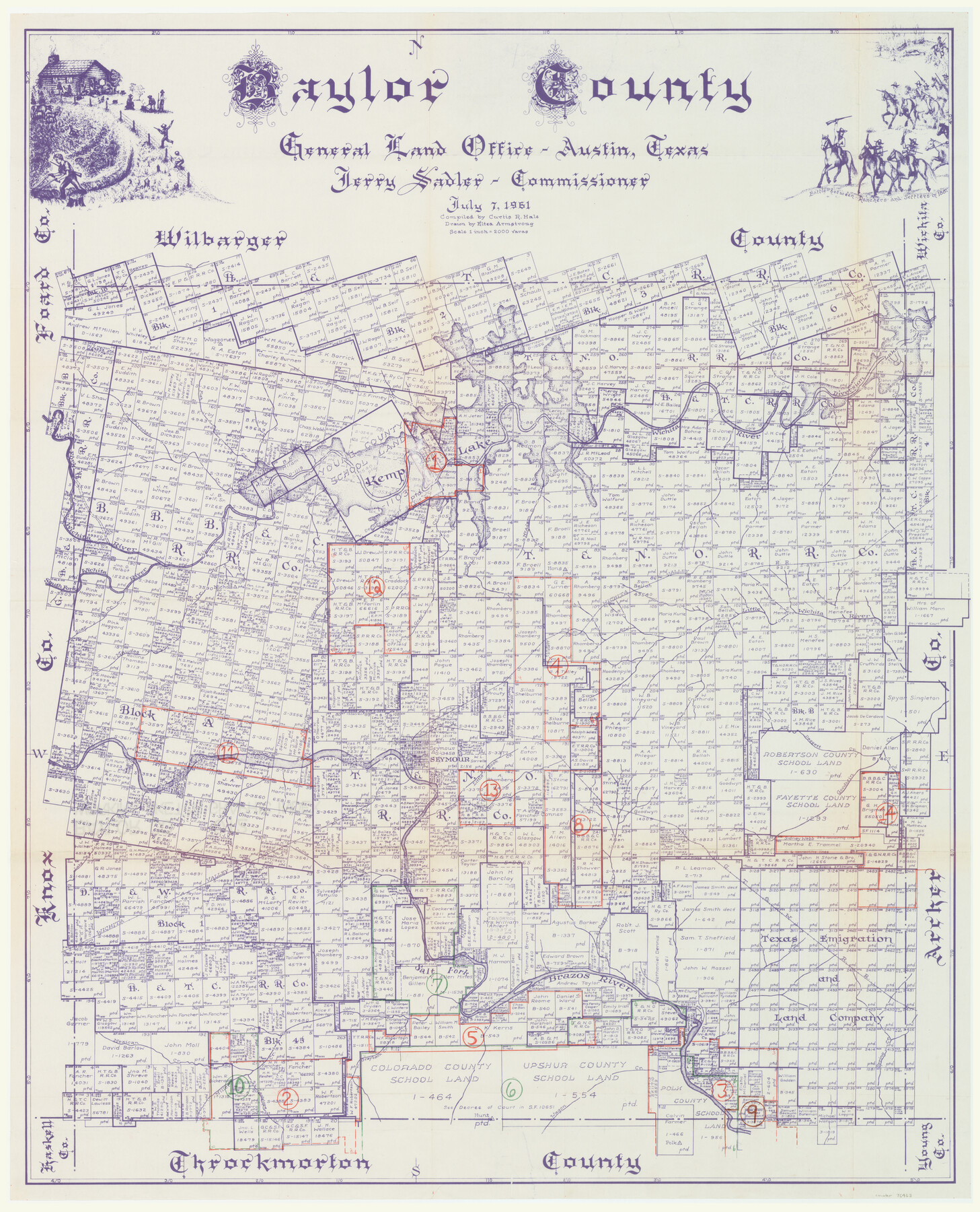
Baylor County Working Sketch Graphic Index
-
Map/Doc
76463
-
Collection
General Map Collection
-
Object Dates
7/7/1961 (Creation Date)
-
People and Organizations
Curtis R. Hale (Compiler)
Eltea Armstrong (Draftsman)
-
Counties
Baylor
-
Subjects
County Surveying Working Sketch
-
Height x Width
41.1 x 33.6 inches
104.4 x 85.3 cm
-
Scale
1" = 2000 varas
Part of: General Map Collection
Blanco County Rolled Sketch 8

Print $20.00
- Digital $50.00
Blanco County Rolled Sketch 8
Size 19.1 x 27.7 inches
Map/Doc 5145
Sulphur River, Talco Sheet

Print $20.00
- Digital $50.00
Sulphur River, Talco Sheet
1917
Size 12.5 x 25.5 inches
Map/Doc 78336
Right of Way and Track Map, Texas & New Orleans R.R. Co. operated by the T. & N. O. R.R. Co., Dallas-Sabine Branch

Print $40.00
- Digital $50.00
Right of Way and Track Map, Texas & New Orleans R.R. Co. operated by the T. & N. O. R.R. Co., Dallas-Sabine Branch
1918
Size 24.6 x 56.4 inches
Map/Doc 64632
Louisiana and Texas Intracoastal Waterway Proposed Extension to Rio Grande Valley

Print $20.00
- Digital $50.00
Louisiana and Texas Intracoastal Waterway Proposed Extension to Rio Grande Valley
1941
Size 28.4 x 41.3 inches
Map/Doc 61890
State Prison Lands Transferred to A&M College, Forest Division, Cherokee County

Print $4.00
- Digital $50.00
State Prison Lands Transferred to A&M College, Forest Division, Cherokee County
1932
Size 11.1 x 20.1 inches
Map/Doc 65086
Map of the Interior of Louisiana with a part of New Mexico

Print $20.00
- Digital $50.00
Map of the Interior of Louisiana with a part of New Mexico
1813
Size 11.9 x 15.7 inches
Map/Doc 94460
Maps of Gulf Intracoastal Waterway, Texas - Sabine River to the Rio Grande and connecting waterways including ship channels

Print $20.00
- Digital $50.00
Maps of Gulf Intracoastal Waterway, Texas - Sabine River to the Rio Grande and connecting waterways including ship channels
1966
Size 14.6 x 22.2 inches
Map/Doc 61970
Flight Mission No. CUG-1P, Frame 105, Kleberg County

Print $20.00
- Digital $50.00
Flight Mission No. CUG-1P, Frame 105, Kleberg County
1956
Size 18.5 x 22.3 inches
Map/Doc 86155

Somervell County Sketch File 5

Print $95.00
- Digital $50.00
Somervell County Sketch File 5
1871
Size 8.8 x 7.7 inches
Map/Doc 36802
Flight Mission No. DCL-7C, Frame 45, Kenedy County

Print $20.00
- Digital $50.00
Flight Mission No. DCL-7C, Frame 45, Kenedy County
1943
Size 15.4 x 15.3 inches
Map/Doc 86033
Goliad County Sketch File A

Print $20.00
- Digital $50.00
Goliad County Sketch File A
1897
Size 30.6 x 32.9 inches
Map/Doc 10465
You may also like
Flight Mission No. BRA-16M, Frame 146, Jefferson County

Print $20.00
- Digital $50.00
Flight Mission No. BRA-16M, Frame 146, Jefferson County
1953
Size 18.4 x 22.3 inches
Map/Doc 85752
Bissell's railway junction point map of Texas / especially designed and adapted for the computation of shortline distances in the application of freight rates promulgated by the Railroad Commission of Texas.

Print $20.00
Bissell's railway junction point map of Texas / especially designed and adapted for the computation of shortline distances in the application of freight rates promulgated by the Railroad Commission of Texas.
1891
Size 31.5 x 26.8 inches
Map/Doc 93600
Fractional Township No. 7 South Range No. 19 East of the Indian Meridian, Indian Territory

Print $20.00
- Digital $50.00
Fractional Township No. 7 South Range No. 19 East of the Indian Meridian, Indian Territory
1897
Size 19.2 x 24.3 inches
Map/Doc 75235
Galveston County Sketch File 32

Print $20.00
- Digital $50.00
Galveston County Sketch File 32
1916
Size 15.2 x 34.3 inches
Map/Doc 11535
Bexar County Sketch File 2

Print $4.00
- Digital $50.00
Bexar County Sketch File 2
1849
Size 9.1 x 8.3 inches
Map/Doc 14471
Hardeman County Sketch File 7

Print $10.00
- Digital $50.00
Hardeman County Sketch File 7
Size 8.9 x 14.1 inches
Map/Doc 24997
Edwards County Sketch File 14

Print $24.00
- Digital $50.00
Edwards County Sketch File 14
1891
Size 12.9 x 8.7 inches
Map/Doc 21703
Harris County Working Sketch 120

Print $20.00
- Digital $50.00
Harris County Working Sketch 120
1985
Size 29.3 x 14.6 inches
Map/Doc 66012
Val Verde County Working Sketch 44

Print $40.00
- Digital $50.00
Val Verde County Working Sketch 44
1945
Size 49.7 x 39.5 inches
Map/Doc 72179
Winkler County

Print $20.00
- Digital $50.00
Winkler County
1932
Size 39.4 x 38.7 inches
Map/Doc 73328
Concho County Working Sketch 14

Print $20.00
- Digital $50.00
Concho County Working Sketch 14
1955
Size 24.7 x 21.0 inches
Map/Doc 68196
Harrison County Working Sketch 14

Print $20.00
- Digital $50.00
Harrison County Working Sketch 14
1961
Size 35.6 x 32.0 inches
Map/Doc 66034