Edwards County Sketch File 14
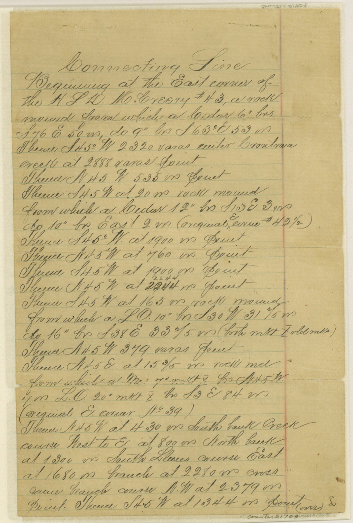
[Field notes of a connecting line from east corner H. L. D. McCreery to east corner of survey 14]
-
Map/Doc
21703
-
Collection
General Map Collection
-
Object Dates
1891/2/18 (Creation Date)
1891/9/4 (File Date)
1891/2/20 (Survey Date)
-
People and Organizations
Otto Groos (Surveyor/Engineer)
D.O. Siminds (Chainman)
Clark Gains (Chainman)
-
Counties
Edwards
-
Subjects
Surveying Sketch File
-
Height x Width
12.9 x 8.7 inches
32.8 x 22.1 cm
-
Medium
paper, manuscript
-
Features
Crontra Creek
South Llano River
Llano River
Green Lake
Part of: General Map Collection
Pecos County Boundary File 1a

Print $12.00
- Digital $50.00
Pecos County Boundary File 1a
Size 12.6 x 8.3 inches
Map/Doc 57855
Navarro County Working Sketch 18

Print $20.00
- Digital $50.00
Navarro County Working Sketch 18
2009
Size 31.9 x 38.0 inches
Map/Doc 89044
Archer County Sketch File 21

Print $40.00
- Digital $50.00
Archer County Sketch File 21
Size 30.3 x 19.8 inches
Map/Doc 10830
Sutton County Sketch File 19

Print $8.00
- Digital $50.00
Sutton County Sketch File 19
1914
Size 11.4 x 8.8 inches
Map/Doc 37447
Township 2 South Range 12 West, South Western District, Louisiana

Print $20.00
- Digital $50.00
Township 2 South Range 12 West, South Western District, Louisiana
1884
Size 19.7 x 24.7 inches
Map/Doc 65882
Coke County Working Sketch 6

Print $20.00
- Digital $50.00
Coke County Working Sketch 6
1914
Size 19.1 x 15.7 inches
Map/Doc 68043
Shackelford County Working Sketch 8

Print $20.00
- Digital $50.00
Shackelford County Working Sketch 8
1973
Size 31.9 x 28.7 inches
Map/Doc 63848
Caddo Lake Subdivision, Copied from Sketch in MF 000964

Print $20.00
- Digital $50.00
Caddo Lake Subdivision, Copied from Sketch in MF 000964
1918
Size 32.5 x 28.0 inches
Map/Doc 1929
Laguna Madre, T-9210

Print $20.00
- Digital $50.00
Laguna Madre, T-9210
Size 34.6 x 31.9 inches
Map/Doc 73601
Blanco County Working Sketch 40

Print $20.00
- Digital $50.00
Blanco County Working Sketch 40
1986
Size 28.3 x 24.5 inches
Map/Doc 67400
Brewster County Working Sketch 78

Print $20.00
- Digital $50.00
Brewster County Working Sketch 78
1970
Size 31.6 x 44.3 inches
Map/Doc 67678
Gaines County Rolled Sketch 9

Print $20.00
- Digital $50.00
Gaines County Rolled Sketch 9
Size 20.9 x 29.8 inches
Map/Doc 5929
You may also like
Hays County Sketch File 5

Print $4.00
- Digital $50.00
Hays County Sketch File 5
1847
Size 12.7 x 8.3 inches
Map/Doc 26206
Rusk County Sketch File 45

Print $8.00
Rusk County Sketch File 45
1959
Size 11.3 x 8.8 inches
Map/Doc 35591
Webb County Sketch File 9-1

Print $20.00
- Digital $50.00
Webb County Sketch File 9-1
1879
Size 15.8 x 15.7 inches
Map/Doc 12622
Real County Rolled Sketch 18

Print $20.00
- Digital $50.00
Real County Rolled Sketch 18
Size 21.2 x 27.7 inches
Map/Doc 7465
Blanco County Sketch File 25

Print $40.00
- Digital $50.00
Blanco County Sketch File 25
1888
Size 17.1 x 14.2 inches
Map/Doc 14616
Hopkins County Sketch File 10a

Print $4.00
- Digital $50.00
Hopkins County Sketch File 10a
1856
Size 12.2 x 7.8 inches
Map/Doc 26702
Jefferson Co.

Print $20.00
- Digital $50.00
Jefferson Co.
1978
Size 47.0 x 41.1 inches
Map/Doc 77329
Foard County Rolled Sketch 13

Print $20.00
- Digital $50.00
Foard County Rolled Sketch 13
1958
Size 25.2 x 31.4 inches
Map/Doc 5887
Flight Mission No. DQN-2K, Frame 95, Calhoun County

Print $20.00
- Digital $50.00
Flight Mission No. DQN-2K, Frame 95, Calhoun County
1953
Size 18.6 x 22.3 inches
Map/Doc 84285
Map of Hill County

Print $40.00
- Digital $50.00
Map of Hill County
1884
Size 80.1 x 68.0 inches
Map/Doc 82049
Wharton County Rolled Sketch 3

Print $20.00
- Digital $50.00
Wharton County Rolled Sketch 3
Size 28.9 x 31.4 inches
Map/Doc 8228
Uvalde County Boundary File 1a

Print $12.00
- Digital $50.00
Uvalde County Boundary File 1a
Size 14.5 x 8.9 inches
Map/Doc 59551