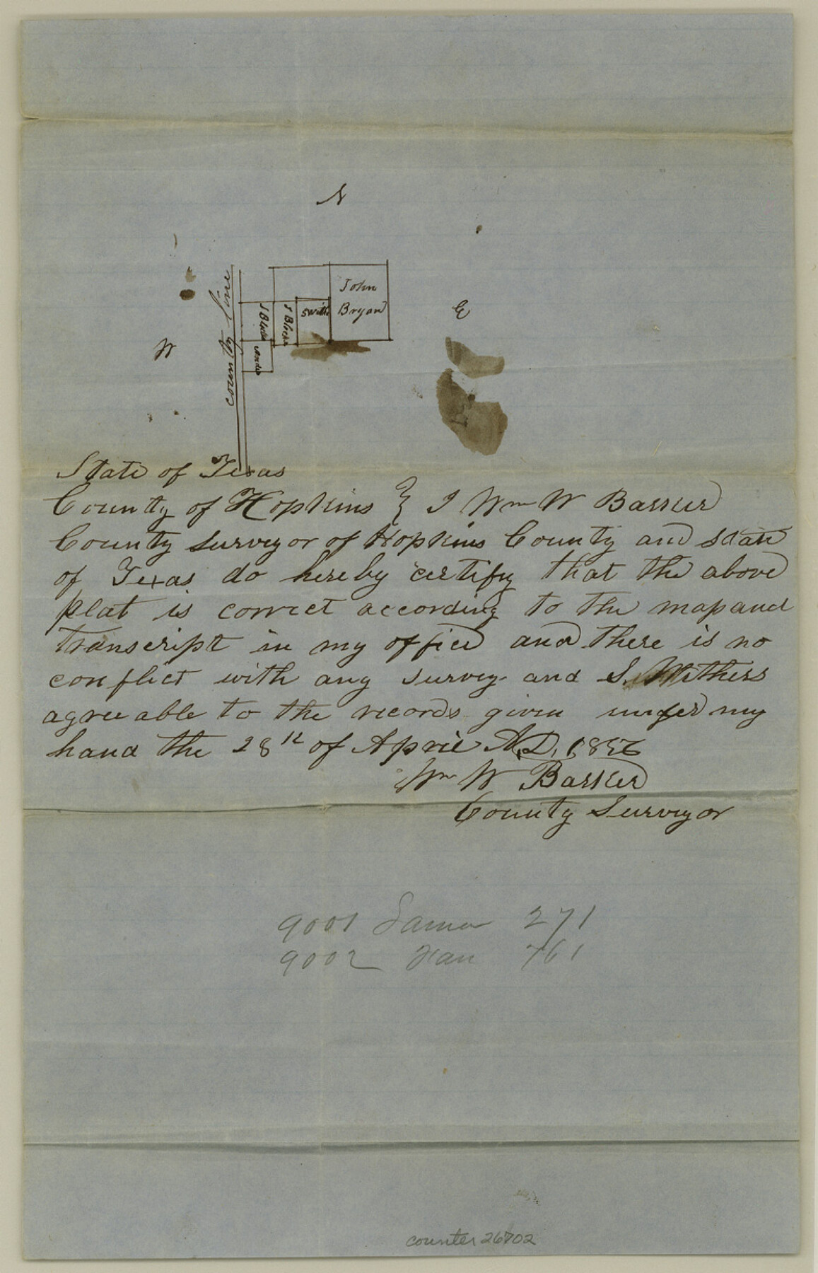
Hopkins County Sketch File 10a
[Sketch southwest of Sulphur Springs]
-
Map/Doc
26702
-
Collection
General Map Collection
-
Object Dates
4/26/1856 (Creation Date)
-
People and Organizations
William W. Barker (Surveyor/Engineer)
-
Counties
Hopkins
-
Subjects
Surveying Sketch File
-
Height x Width
12.2 x 7.8 inches
31.0 x 19.8 cm
-
Medium
paper, manuscript
Part of: General Map Collection
Navarro County Working Sketch 13

Print $20.00
- Digital $50.00
Navarro County Working Sketch 13
1980
Size 15.6 x 16.1 inches
Map/Doc 71243
Real County Rolled Sketch 18

Print $20.00
- Digital $50.00
Real County Rolled Sketch 18
Size 22.0 x 27.9 inches
Map/Doc 7460

Galveston County Sketch File 2

Print $2.00
- Digital $50.00
Galveston County Sketch File 2
1845
Size 8.3 x 11.1 inches
Map/Doc 23349
Pecos County Sketch File 28a

Print $14.00
- Digital $50.00
Pecos County Sketch File 28a
1911
Size 14.5 x 8.9 inches
Map/Doc 33683
Glasscock County Working Sketch 1

Print $20.00
- Digital $50.00
Glasscock County Working Sketch 1
Size 26.6 x 43.0 inches
Map/Doc 63174
Travis County Sketch File 53

Print $6.00
- Digital $50.00
Travis County Sketch File 53
1945
Size 14.2 x 9.0 inches
Map/Doc 38395
Coleman County Sketch File A1

Print $6.00
- Digital $50.00
Coleman County Sketch File A1
Size 5.4 x 7.7 inches
Map/Doc 18664
Gregg County Sketch File 12

Print $20.00
- Digital $50.00
Gregg County Sketch File 12
Size 17.3 x 24.1 inches
Map/Doc 11589
[Aransas Bay]
![72970, [Aransas Bay], General Map Collection](https://historictexasmaps.com/wmedia_w700/maps/72970.tif.jpg)
Print $20.00
- Digital $50.00
[Aransas Bay]
1846
Size 24.3 x 18.3 inches
Map/Doc 72970
A New Map of the United States of America

Print $20.00
- Digital $50.00
A New Map of the United States of America
1850
Size 17.7 x 27.8 inches
Map/Doc 89219
Crane County Working Sketch 11

Print $20.00
- Digital $50.00
Crane County Working Sketch 11
1941
Size 18.8 x 18.4 inches
Map/Doc 68288
You may also like
Fort Bend County State Real Property Sketch 18

Print $40.00
- Digital $50.00
Fort Bend County State Real Property Sketch 18
2006
Size 17.7 x 24.0 inches
Map/Doc 88615
Briscoe County Sketch File 1

Print $5.00
- Digital $50.00
Briscoe County Sketch File 1
1880
Size 9.1 x 14.8 inches
Map/Doc 16413
Liberty County Working Sketch 44

Print $20.00
- Digital $50.00
Liberty County Working Sketch 44
1953
Size 21.3 x 30.2 inches
Map/Doc 70503
Flight Mission No. BRA-6T, Frame 117, Jefferson County

Print $20.00
- Digital $50.00
Flight Mission No. BRA-6T, Frame 117, Jefferson County
1957
Size 18.6 x 18.4 inches
Map/Doc 85786
El Paso County Sketch File 12

Print $22.00
- Digital $50.00
El Paso County Sketch File 12
1887
Size 8.1 x 5.9 inches
Map/Doc 22004
Flight Mission No. DQN-7K, Frame 13, Calhoun County

Print $20.00
- Digital $50.00
Flight Mission No. DQN-7K, Frame 13, Calhoun County
1953
Size 18.4 x 22.1 inches
Map/Doc 84464
Calhoun County Rolled Sketch 36

Print $40.00
- Digital $50.00
Calhoun County Rolled Sketch 36
2003
Size 33.3 x 49.0 inches
Map/Doc 78655
Travis County Rolled Sketch 13

Print $20.00
- Digital $50.00
Travis County Rolled Sketch 13
Size 28.0 x 20.4 inches
Map/Doc 8016
Grimes County Working Sketch 4

Print $20.00
- Digital $50.00
Grimes County Working Sketch 4
1948
Size 20.0 x 24.5 inches
Map/Doc 63295
Andrews County Rolled Sketch 26

Print $40.00
- Digital $50.00
Andrews County Rolled Sketch 26
1948
Size 78.3 x 13.2 inches
Map/Doc 8398
Flight Mission No. DCL-5C, Frame 26, Kenedy County

Print $20.00
- Digital $50.00
Flight Mission No. DCL-5C, Frame 26, Kenedy County
1943
Size 18.5 x 22.3 inches
Map/Doc 85838
Current Miscellaneous File 102

Print $611.00
- Digital $50.00
Current Miscellaneous File 102
Size 11.5 x 7.1 inches
Map/Doc 74379